জিব্রাল্টার: সংশোধিত সংস্করণের মধ্যে পার্থক্য
বিষয়বস্তু বিয়োগ হয়েছে বিষয়বস্তু যোগ হয়েছে
সম্পাদনা সারাংশ নেই ট্যাগ: মোবাইল সম্পাদনা মোবাইল ওয়েব সম্পাদনা |
সম্পাদনা সারাংশ নেই ট্যাগ: মোবাইল সম্পাদনা মোবাইল ওয়েব সম্পাদনা |
||
| ১ নং লাইন: | ১ নং লাইন: | ||
{{Infobox country |
|||
| conventional_long_name = জিব্রাল্টার |
|||
| common_name = Gibraltar |
|||
| image_flag = Flag of Gibraltar.svg |
|||
| image_coat = Coat of arms of Gibraltar1.svg |
|||
| symbol_width = 75px |
|||
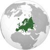
| image_map = EU-Gibraltar.svg |
|||
| map_caption = {{map caption |location_color=dark green|country={{nobold|Gibraltar}}|region=Europe |region_color=dark grey |subregion=the [[European Union]] |subregion_color=green}} |
|||
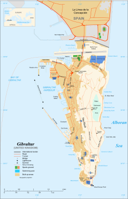
| image_map2 = Gibraltar map-en-edit2.svg |
|||
| map2_width = 250px |
|||
| map_caption2 = মানচিত্র |
|||
| national_motto = {{native phrase|la|"Montis Insignia Calpe"|italics=off}}<br/>{{small|"Badge of the Rock of Gibraltar"<ref>{{cite web |url =https://www.gibraltar.gov.gi/national-symbols|title =National Symbols |publisher =Gibraltar.gov.gi|accessdate = 21 June 2013}}</ref>}} |
|||
| national_anthem = "[[গড সেইভ দ্য কুইন]]" {{small|(দাপ্তরিক)}} <center>[[File:United States Navy Band - God Save the Queen.ogg]]</center><br/>"[[Gibraltar Anthem]]" {{small|(local)}}<ref>{{cite web |url=https://www.cia.gov/library/publications/the-world-factbook/geos/gi.html |title=Gibraltar: National anthem |work=[[CIA World Factbook]] |publisher=[[Central Intelligence Agency]] |accessdate=25 September 2011 |quote=National anthem: name: "Gibraltar Anthem" ... note: adopted 1994; serves as a local anthem; because Gibraltar is a territory of the United Kingdom, "God Save the Queen" remains official (see United Kingdom)}}</ref> |
|||
| status = {{nowrap|[[British Overseas Territories|British Overseas Territory]]}} |
|||
| official_languages = [[English language|English]] |
|||
| languages_type = মৌখিক ভাষা |
|||
| languages = {{hlist |[[English language|ইংরেজি]] |[[Spanish language|স্প্যানিশ]] |[[Llanito]]}} |
|||
| capital = Gibraltar |
|||
| coordinates = {{Coord|36|8|N|5|21|W|type:city}} |
|||
| largest_settlement_type = district<br/>{{nobold|(by population)}} |
|||
| largest_settlement = [[Westside, Gibraltar|Westside]] |
|||
| ethnic_groups = {{unbulleted list |[[Gibraltarian people|Gibraltarian]]<sup>a</sup> |other British |[[Maghrebis]] |[[South Asian ethnic groups|South Asians]]}} |
|||
| demonym = {{nowrap|[[Gibraltarian people|Gibraltarian]]<br/>Llanito {{small|([[colloquial]])}}}} |
|||
| government_type = [[Representative democracy|Representative democratic]] [[Parliamentary system|parliamentary]] [[Dependent territory|dependency]] under [[constitutional monarchy]] |
|||
| leader_title1 = [[Monarchy of the United Kingdom|Monarch]] |
|||
| leader_name1 = [[Elizabeth II]] |
|||
| leader_title2 = [[Governor of Gibraltar|Governor]] |
|||
| leader_name2 = {{nowrap|[[Ed Davis (Royal Marines officer)|Ed Davis]]}} |
|||
| leader_title3 = [[Chief Minister of Gibraltar|Chief Minister]] |
|||
| leader_name3 = [[Fabian Picardo]] |
|||
| leader_title4 = [[Mayor of Gibraltar|Mayor]] |
|||
| leader_name4 = [[Kaiane Aldorino]] |
|||
| legislature = [[Gibraltar Parliament|Parliament]] |
|||
| area_rank = <!-- Area rank should match [[List of countries and dependencies by area]];(should not be any here as it is listed with a dash) --> |
|||
| area_magnitude = 1 E6 |
|||
| area_km2 = 6.7 |
|||
| area_sq_mi = 2.6 <!--Do not remove per [[WP:MOSNUM]]--> |
|||
| percent_water = 0 |
|||
| population_estimate = 32,194<ref name="gibraltar.gov.gi">{{cite web|url=https://www.gibraltar.gov.gi/new/sites/default/files/HMGoG_Documents/Full%20Census%20Report%202012%20FINAL.pdf|format=PDF|title=Census of Gibraltar|date=2012|website=Gibraltar.gov.gi|accessdate=2017-08-03}}</ref> |
|||
| population_estimate_rank = 222nd |
|||
| population_estimate_year = 2015 |
|||
| population_census = |
|||
| population_census_year = 2012 |
|||
| population_density_km2 = 4,328 |
|||
| population_density_sq_mi = 11,320 <!--Do not remove per [[WP:MOSNUM]]--> |
|||
| population_density_rank = 5th |
|||
| GDP_PPP = £1.64 billion |
|||
| GDP_PPP_rank = |
|||
| GDP_PPP_year = 2013 |
|||
| GDP_PPP_per_capita = £50,941 |
|||
| GDP_PPP_per_capita_rank = n/a |
|||
| sovereignty_type = [[History of Gibraltar|Formation]] |
|||
| established_event1 = [[Capture of Gibraltar|Captured]] |
|||
| established_date1 = 4 August 1704<ref name="New Style">Gibraltar was captured on 24 July 1704 [[Old Style]] or 4 August 1704 [[New Style]].</ref> |
|||
| established_event2 = [[Treaty of Utrecht|Ceded]] |
|||
| established_date2 = 11 April 1713<ref>The treaty was signed on 31 March 1713 [[Old Style]] or 11 April 1713 [[New Style]] ([[:s:Peace and Friendship Treaty of Utrecht between France and Great Britain|Peace and Friendship Treaty of Utrecht between France and Great Britain]]).</ref> |
|||
| established_event3 = [[Gibraltar National Day|National Day]] |
|||
| established_date3 = 10 September 1967 |
|||
| established_event4 = Joined the [[European Economic Community|EEC]] |
|||
| established_date4 = 1 January 1973<sup>b</sup> |
|||
| Gini_year = |
|||
| Gini_change = <!--increase/decrease/steady--> |
|||
| Gini = <!--number only--> |
|||
| Gini_ref = |
|||
| Gini_rank = |
|||
| HDI_year = 2015 |
|||
| HDI_change = <!--increase/decrease/steady--> |
|||
| HDI = 0.861 <!--number only--> |
|||
| HDI_ref = <ref>[https://books.google.com/books?id=hGAiCwAAQBAJ&pg=PA62#v=onepage&q&f=false Quality of Life, Balance of Powers, and Nuclear Weapons (2015)] Avakov, Aleksandr Vladimirovich. Algora Publishing, 1 Apr 2015.</ref> |
|||
| HDI_rank = 40th |
|||
| currency = [[Gibraltar pound]] ([[Pound sign|£]])<sup>c</sup> |
|||
| currency_code = GIP |
|||
| country_code = {{hlist |[[List of Internet TLDs|.gi]] |[[ISO 3166-1 alpha-2|GI]] |[[ISO 3166-1 alpha-3|GIB]] |[[ISO 3166-1 numeric|292]] |[[List of FIFA country codes|GBZ]]}} |
|||
| time_zone = [[Central European Time|CET]] |
|||
| utc_offset = +1 |
|||
| time_zone_DST = [[Central European Summer Time|CEST]] |
|||
| utc_offset_DST = +2 |
|||
| date_format = দদ/মম/বব |
|||
| drives_on = ডান<sup>d</sup> |
|||
| calling_code = [[+350]]<sup>e</sup> |
|||
| patron_saint = {{unbulleted list |[[Bernard of Clairvaux]] |[[Our Lady of Europe]]}} |
|||
| cctld = [[.gi]]<sup>f</sup> |
|||
| footnote_a = Of mixed [[Genoa|Genoese]], [[Maltese people|Maltese]], [[Portuguese people|Portuguese]] and [[Spanish people|Spanish]] descent. |
|||
}} |
|||
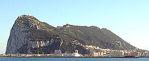
[[চিত্র:Rock of Gibraltar northwest.jpg|thumb|300px|right|উপসাগর থেকে তোলা জিব্রাল্টারের পশ্চিম পার্শ্বের আলোকচিত্র]] |
[[চিত্র:Rock of Gibraltar northwest.jpg|thumb|300px|right|উপসাগর থেকে তোলা জিব্রাল্টারের পশ্চিম পার্শ্বের আলোকচিত্র]] |
||
'''জিব্রাল্টার''' [[যুক্তরাজ্য|যুক্তরাজ্যের]] অধীনস্থ একটি এলাকা যা [[স্পেন|স্পেনের]] দক্ষিণে, আটলান্টিক মহাসাগর থেকে ভূমধ্যসাগরের প্রবেশপথে অবস্থিত। |
'''জিব্রাল্টার''' [[যুক্তরাজ্য|যুক্তরাজ্যের]] অধীনস্থ একটি এলাকা যা [[স্পেন|স্পেনের]] দক্ষিণে, আটলান্টিক মহাসাগর থেকে ভূমধ্যসাগরের প্রবেশপথে অবস্থিত। |
||
| ৫ নং লাইন: | ৮৯ নং লাইন: | ||
{{ইউরোপ}} |
{{ইউরোপ}} |
||
==তথ্যসূত্র== |
==তথ্যসূত্র== |
||
{{সূত্র তালিকা}} |
{{সূত্র তালিকা}} |
||
১০:৪৮, ১৬ মে ২০১৮ তারিখে সংশোধিত সংস্করণ
জিব্রাল্টার | |
|---|---|
 Gibraltar-এর অবস্থান (dark green) – Europe-এ (green & dark grey) | |
 মানচিত্র | |
| অবস্থা | British Overseas Territory |
| রাজধানী | Gibraltar ৩৬°৮′ উত্তর ৫°২১′ পশ্চিম / ৩৬.১৩৩° উত্তর ৫.৩৫০° পশ্চিম |
| বৃহত্তম district (by population) | Westside |
| সরকারি ভাষা | English |
| মৌখিক ভাষা | |
| নৃগোষ্ঠী |
|
| জাতীয়তাসূচক বিশেষণ | Gibraltarian Llanito (colloquial) |
| সরকার | Representative democratic parliamentary dependency under constitutional monarchy |
• Monarch | Elizabeth II |
• Governor | Ed Davis |
| Fabian Picardo | |
• Mayor | Kaiane Aldorino |
| আইন-সভা | Parliament |
| Formation | |
• Captured | 4 August 1704[৩] |
• Ceded | 11 April 1713[৪] |
| 10 September 1967 | |
• Joined the EEC | 1 January 1973b |
| আয়তন | |
• মোট | ৬.৭ কিমি২ (২.৬ মা২) |
• পানি (%) | 0 |
| জনসংখ্যা | |
• 2015 আনুমানিক | 32,194[৫] (222nd) |
• ঘনত্ব | ৪,৩২৮/কিমি২ (১১,২০৯.৫/বর্গমাইল) (5th) |
| জিডিপি (পিপিপি) | 2013 আনুমানিক |
• মোট | £1.64 billion |
• মাথাপিছু | £50,941 (n/a) |
| মানব উন্নয়ন সূচক (2015) | 0.861[৬] অতি উচ্চ · 40th |
| মুদ্রা | Gibraltar pound (£)c (GIP) |
| সময় অঞ্চল | ইউটিসি+1 (CET) |
• গ্রীষ্মকালীন (ডিএসটি) | ইউটিসি+2 (CEST) |
| তারিখ বিন্যাস | দদ/মম/বব |
| গাড়ী চালনার দিক | ডানd |
| কলিং কোড | +350e |
| ইন্টারনেট টিএলডি | .gif |
| |

জিব্রাল্টার যুক্তরাজ্যের অধীনস্থ একটি এলাকা যা স্পেনের দক্ষিণে, আটলান্টিক মহাসাগর থেকে ভূমধ্যসাগরের প্রবেশপথে অবস্থিত।
জিব্রাল্টার নামটি আরবি নাম "জাবাল আল তারিক" (جبل طارق "তারিকের পাথর/শিলা/পাহাড়")-এর স্পেনীয় অপভ্রষ্ট রূপ। ৭১১ সালে উমাইয়াহ খলিফাদের বার্বার গোত্রীয় সেনানেতা তারিক ইবন জিয়াদ স্পেন বিজয়ের উদ্দেশ্যে উত্তর আফ্রিকা থেকে জিব্রাল্টার প্রণালী পার হয়ে এখানে প্রথম পদার্পণ করেন। স্পেনীয় থেকে ইউরোপের অন্যান্য ভাষাতে এবং সেই সূত্রে বিশ্বের অন্য সব ভাষাট "জিব্রাল্টার" শব্দটি এসেছে। এমনকি আধুনিক আরবিতেও এটিকে জিব্রাল্টার-ই বলা হয়।[৭]
তথ্যসূত্র
- ↑ "National Symbols"। Gibraltar.gov.gi। সংগ্রহের তারিখ ২১ জুন ২০১৩।
- ↑ "Gibraltar: National anthem"। CIA World Factbook। Central Intelligence Agency। সংগ্রহের তারিখ ২৫ সেপ্টেম্বর ২০১১।
National anthem: name: "Gibraltar Anthem" ... note: adopted 1994; serves as a local anthem; because Gibraltar is a territory of the United Kingdom, "God Save the Queen" remains official (see United Kingdom)
- ↑ Gibraltar was captured on 24 July 1704 Old Style or 4 August 1704 New Style.
- ↑ The treaty was signed on 31 March 1713 Old Style or 11 April 1713 New Style (Peace and Friendship Treaty of Utrecht between France and Great Britain).
- ↑ "Census of Gibraltar" (PDF)। Gibraltar.gov.gi। ২০১২। সংগ্রহের তারিখ ২০১৭-০৮-০৩।
- ↑ Quality of Life, Balance of Powers, and Nuclear Weapons (2015) Avakov, Aleksandr Vladimirovich. Algora Publishing, 1 Apr 2015.
- ↑ Hills, George (১৯৭৪)। Rock of Contention: A history of Gibraltar। London: Robert Hale & Company। পৃষ্ঠা 13। আইএসবিএন 0-7091-4352-4।


