প্রবেশদ্বার:ভূমিকম্প/নির্বাচিত নিবন্ধ
Usage[সম্পাদনা]
The "Selected Article" box on the Portal page is randomly generated with the Random Portal Component template. To add an article to be randomly selected, you must:
- Find the next available subpage number from the list of articles below
- Make a new subpage of this page with that number (Portal:Earthquakes/Selected article/<# here>)
- Write a summary of the article using the layout design at Portal:Earthquakes/Selected article/Layout
- Link to the new subpage at the bottom of the list below, like the other subpages
- Update the "max=" attribute on the {{Random portal component}} in the "Selected Article" box on the main page to the number of the subpage you created
Guidelines[সম্পাদনা]
- You must write a summary using only cited information from the article.
- Do not include refs in the summary.
- The selected image must reflect the earthquake best, be it a map or an image of the quake's destructive properties.
- The selected image must be 250px in size.
Selected articles list[সম্পাদনা]
প্রবেশদ্বার:ভূমিকম্প/নির্বাচিত নিবন্ধ/১[সম্পাদনা]
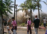
২০০৪ ভারত মহাসাগরে ভূমিকম্প ইন্দোনেশিয়ার সুমাত্রা উপকূলে ৫৮:৫৩ ইউটিসি, ২৬ ডিসেম্বর ঘটে। ভূমিকম্পটি উপকেন্দের সাথে ঘটে।এর প্রভাব পরিমাপ করা হয় ৯.১ থেকে ৯.৩ এর মাত্রায় যা IX এর সর্বোচ্চ মার্কেলি তীব্রতা ছিল।ভারতীয় প্লেট বার্মা প্লেট দ্বারা যখন বিভাজিত হয় তখন ভারতীয় মহাসাগরের সীমান্ত বর্তি বহির্দেশের সমভূমির মধ্য দিয়ে বিধ্বস্ত সুনামির একটি ধারাবাহিকতা সৃষ্টি করে যার ফলে সমুদ্রতলে মেগাথ্রাস্ট ভূমিকম্প ঘটে। এর ফলে ১৪টি দেশের ২,৩০,০০০ থেকে ২,৮০,০০০ জন মানুষ মারা যায় এবং উপকূলিয় অঞ্চল ৩০ মিটার (১০০ ফু) ঢেউয়ে প্লাবীত হয়। এটি লিপিবদ্ধ করা ইতিহাসে সবচেয়ে মারাত্মক প্রাকৃতিক বিপর্যয়ের মধ্যে একটি। ইন্দোনেশিয়াকে কঠিনভাবে ক্ষতিগ্রস্ত দেশ হিসেবে চিহ্নত করা হয়,এর পর শ্রীলংকা, ভারত ও থাইল্যান্ড কে পর্যায় ক্রমে ধরা হয়।
এটি সিজমোগ্রাফে ধারণকৃত তৃতীয় বৃহত্তম ভূমিকম্প। ভূমিকম্পটি ৮.৩ থেকে ১০ মিনিট স্থায়ি ছিল যা সবচেয়ে দীর্ঘতম সময়ের ভূমিকম্প। এটি সমগ্র গ্রহটি কে ১ সেন্টিমিটার (০.৪ ইঞ্চি) পর্যন্ত স্পন্দিত করে এবং আলাস্কার পাশাপাশি অন্যান্য ভূমিকম্পের স্থান সক্রিয় করে তুলে। এর উপকেন্দ্রটি সিমেওলুই এবং মূল ভূখণ্ড ইন্দোনেশিয়ার মধ্যবর্তিতে ছিল।
প্রবেশদ্বার:ভূমিকম্প/নির্বাচিত নিবন্ধ/২[সম্পাদনা]
The geology of the Lassen volcanic area presents a record of sedimentation and volcanic activity in the area in and around Lassen Volcanic National Park in Northern California, U.S.. The park is located in the southernmost part of the Cascade Mountain Range in the Pacific Northwest region of the United States. Oceanic tectonic plates have plunged below the North American Plate in this part of North America for hundreds of millions of years. Heat from these subducting plates have fed scores of volcanoes in California, Oregon, Washington and British Columbia over at least the past 30 million years (see Geology of the Pacific Northwest) and is also responsible for activities in the Lassen volcanic area.
Between 3 and 4 million years ago, volcanic-derived mud flows called lahars streamed down several major mountains that included nearby but now extinct Mount Yana and Mount Maidu to become the Tuscan Formation. Basaltic and later andesitic to dacitic flows of lava covered increasingly larger areas of this formation to eventually form the lava plateau that the park sits on. About 600,000 years ago, Mount Tehama started to rise as a stratovolcano in the southwestern corner of the park, eventually reaching an estimated 11,000 feet (3,350 m) in height. Following a series of eruptions approximately 350,000 years ago, its cone collapsed into itself to form a two-mile (3 km) wide caldera.
প্রবেশদ্বার:ভূমিকম্প/নির্বাচিত নিবন্ধ/৩[সম্পাদনা]
The 1992 Nicaragua earthquake occurred off the coast of Nicaragua on September 2, 1992. Some damage was also reported in Costa Rica. At least 116 people were killed and several more were injured. The quake was located in an active zone of stress and deformation. It created tsunamis disproportionately large for its surface-wave magnitude, or Ms. The first shock of the earthquake occurred at 0:16 GMT and was followed by several strong aftershocks. The quake was most widely felt in the Chinandega and León departments of Nicaragua, though it was also felt elsewhere in Nicaragua at Crucero, Managua and San Marcos and at San José in Costa Rica. It is recorded to be the strongest seismic event ever to hit Nicaragua since the earthquake of 1972.
প্রবেশদ্বার:ভূমিকম্প/নির্বাচিত নিবন্ধ/৪[সম্পাদনা]
The 2008 Sichuan earthquake (চীনা: 四川大地震; ফিনিন: Sìchuān dà dìzhèn), or "Great Sichuan Earthquake", which measured at 8.0 Ms and 8.3 Mw according to China Earthquake Administration (CEA), and 7.9 Mw according to USGS, occurred at 14:28:01.42 CST (06:28:01.42 UTC) on 12 May 2008 in Sichuan province of China. It was also known as the Wenchuan earthquake (চীনা: 汶川大地震; ফিনিন: Wènchuān dà dìzhèn), after the earthquake's epicenter in Wenchuan County, Sichuan province. The epicenter was ৮০ কিলোমিটার (৫০ মা) west-northwest of Chengdu, the capital of Sichuan, with a depth of ১৯ কিলোমিটার (১২ মা). The earthquake was felt as far away as Beijing (১,৫০০ কিলোমিটার (৯৩২ মা) away) and Shanghai (১,৭০০ কিলোমিটার (১,০৫৬ মা) away), where office buildings swayed with the tremor. The earthquake was also felt in nearby countries.
Official figures (as of July 6, 2008 12:00 CST) state that 69,197 are confirmed dead, including 68,636 in Sichuan province, and 374,176 injured, with 18,340 listed as missing. The earthquake left about 4.8 million people homeless, though the number could be as high as 11 million. It is the deadliest and strongest earthquake to hit China since the 1976 Tangshan earthquake, which killed at least 240,000 people. Approximately 15 million people lived in the affected area.
প্রবেশদ্বার:ভূমিকম্প/নির্বাচিত নিবন্ধ/৫[সম্পাদনা]
The July 2006 Java earthquake was a magnitude 7.7 earthquake off the southwestern coast of Java, Indonesia. It occurred on July 17, 2006, at 08:24 UTC (15:24 local time).
The U.S. Geological Survey placed the epicentre of the quake at ৯°১৭′৪২″ দক্ষিণ ১০৭°২০′৪৯″ পূর্ব / ৯.২৯৫° দক্ষিণ ১০৭.৩৪৭° পূর্ব, and its hypocentre at a depth of 48.6 km below the seabed. This is 225 km (140 miles) NE of Christmas Island, 240 km (150 miles) SSW of Tasikmalaya, Indonesia, and 358 km (222 miles) S of Jakarta, the capital and largest city of Indonesia.
According to the U.S. Geological Survey:
"The earthquake occurred as a result of thrust-faulting on the boundary between the Australia plate and the Sunda plate. On this part of their mutual boundary, the Australia plate moves north-northeast with respect to the Sunda plate at about 59 mm/year. The Australia plate thrusts beneath the Sunda plate at the Java trench, south of Java, and is subducted to progressively greater depths beneath Java and north of Java. The earthquake occurred on the shallow part of the plate boundary, about 50 km north of the Java trench."
প্রবেশদ্বার:ভূমিকম্প/নির্বাচিত নিবন্ধ/৬[সম্পাদনা]
The 2002 Bou'in-Zahra earthquake occurred on June 22, 2002 at 02:58 UTC (7:28 a.m. Iran Standard Time) in northwestern Iran, which is crossed by several major fault lines. The earthquake's epicenter was near the small village of Bou'in-Zahra in the Qazvin Province, an area known for destructive earthquakes. Measuring 6.5 on the Richter scale and 6.3 on the Moment magnitude scale, the quake killed at least 261 people and injured 1,300 more while they were still in their homes. According to the International Institute of Earthquake Engineering and Seismology (IIEES), the earthquake was felt as far away as the capital city of Tehran, approximately ১৮০ মাইল (২৯০ কিমি) east of the epicenter. Over 20 aftershocks followed the earthquake.
Although the Iranian government claimed that relief work was mostly complete, residents of Changureh complained that the promised tents, food, and medicine had not reached them, albeit them waiting in near-freezing temperatures for weeks. Residents of the village of Avaj resorted to throwing stones at the car of a government minister.
প্রবেশদ্বার:ভূমিকম্প/নির্বাচিত নিবন্ধ/৭[সম্পাদনা]
The geology of the Grand Canyon area exposes one of the most complete sequences of rock anywhere, representing a period of nearly 2 billion years of the Earth's history in that part of North America. The major sedimentary rock layers exposed in the Grand Canyon and in the Grand Canyon National Park area range in age from 200 million to nearly 2 billion years old. Most were deposited in warm, shallow seas and near ancient, long-gone sea shores. Both marine and terrestrial sediments are represented, including fossilized sand dunes from an extinct desert.
Uplift of the region started about 75 million years ago in the Laramide orogeny, a mountain-building event that is largely responsible for creating the Rocky Mountains to the east. Accelerated uplift started 17 million years ago when the Colorado Plateaus (on which the area is located) were being formed. In total these layers were uplifted an estimated 10,000 feet (3000 m) which enabled the ancestral Colorado River to cut its channel into the four plateaus that constitute this area.
The canyon, created by the Colorado River is 277 miles (446 km) long, ranges in width from 4 to 18 miles (6.4 to 29 km) and attains a depth of more than a mile (1.6 km). Nearly two billion years of the Earth's history have been exposed as the Colorado River and its tributaries cut their channels through layer after layer of rock while the Colorado Plateau was uplifted.
Wetter climates brought upon by ice ages starting 2 million years ago greatly increased excavation of the Grand Canyon, which was nearly as deep as it is now by 1.2 million years ago. Also about 2 million years ago volcanic activity started to deposit ash and lava over the area. At least 13 large lava flows dammed the Colorado River, forming huge lakes that were up to 2000 feet (600 m) deep and 100 miles (160 km) long. The nearly 40 identified rock layers and 14 major unconformities (gaps in the geologic record) of the Grand Canyon form one of the most studied sequences of rock in the world.
প্রবেশদ্বার:ভূমিকম্প/নির্বাচিত নিবন্ধ/৮[সম্পাদনা]
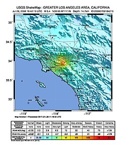
The 2008 Chino Hills earthquake occurred at 11:42:15 am PDT (18:42:15 UTC) on July 29, 2008, in Southern California. The epicenter of the magnitude 5.4 earthquake was in Chino Hills, approximately ২৮ মাইল (৪৫ কিমি) east-southeast of downtown Los Angeles.
Though no lives were lost during the earthquake, it caused considerable damage in numerous structures throughout the area and caused some amusement park facilities to shut down their rides. The earthquake led to increased discussion regarding the possibility of a stronger earthquake in the future.
প্রবেশদ্বার:ভূমিকম্প/নির্বাচিত নিবন্ধ/৯[সম্পাদনা]
Lake Toba (Indonesian: Danau Toba) is a lake and supervolcano, 100 km long and 30 km wide, and 505 m. (1,666 ft.) at its deepest point, in the middle of the northern part of the Indonesian island of Sumatra with a surface elevation of about 900 m (3,000 feet), stretching from ২°৫৩′ উত্তর ৯৮°৩১′ পূর্ব / ২.৮৮° উত্তর ৯৮.৫২° পূর্ব to ২°২১′ উত্তর ৯৯°০৬′ পূর্ব / ২.৩৫° উত্তর ৯৯.১° পূর্ব. It is the largest volcanic lake in the world. In addition, it is the site of the 75,000-year-old supervolcanic eruption, the largest in the last 25 million years; where it staged a massive climate-changing event that scientists believe might have wiped out much of humanity. The massive eruption is believed to have a VEI intensity of 8.


