ডালাস: সংশোধিত সংস্করণের মধ্যে পার্থক্য
বিষয়বস্তু বিয়োগ হয়েছে বিষয়বস্তু যোগ হয়েছে
Luckas-bot (আলোচনা | অবদান) অ r2.7.1) (রোবট যোগ করছে: be:Горад Далас |
সম্পাদনা সারাংশ নেই |
||
| ১ নং লাইন: | ১ নং লাইন: | ||
'''ডালাস''' [[মার্কিন যুক্তরাষ্ট্র|মার্কিন যুক্তরাষ্ট্রের]] [[টেক্সাস]] অঙ্গরাজ্যের একটি বৃহৎ শহর। |
'''ডালাস''' [[মার্কিন যুক্তরাষ্ট্র|মার্কিন যুক্তরাষ্ট্রের]] [[টেক্সাস]] অঙ্গরাজ্যের একটি বৃহৎ শহর। |
||
{{About|the city in the U.S. state of Texas}} |
|||
{{Infobox settlement |
|||
|name = ডালাস, টেক্সাস |
|||
|official_name = |
|||
|settlement_type = [[City (Washington)|শহর]] |
|||
|nickname = "বিগ ডি" |
|||
|image_skyline = TE-Collage Dallas.png |
|||
|imagesize = |
|||
|image_caption = Clockwise from top: [[ডাউনটাউন ডালাস]] from the [[Trinity River (Texas)|Trinity River]] Greenbelt Park, the [[Morton H. Meyerson Symphony Center|Meyerson Symphony Center]], the [[Southern Methodist University (SMU)]] campus, and [[Bank of America Plaza (Dallas)|Bank of America Plaza]] |
|||
|image_flag = Flag of Dallas.svg |
|||
|image_seal = Seal of Dallas.svg |
|||
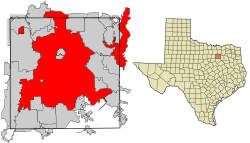
|image_map = Dallas County Texas Incorporated Areas Dallas highlighted.svg |
|||
|mapsize = 250px |
|||
|map_caption = Location in [[Dallas County, Texas|Dallas County]] and the state of Texas |
|||
|image_map1 = |
|||
|mapsize1 = |
|||
|map_caption1 = |
|||
|pushpin_map = |
|||
|pushpin_map_caption = Location in the United States| |
|||
|coordinates_region = US-TX |
|||
|subdivision_type = Country |
|||
|subdivision_name = United States |
|||
|subdivision_type1 = State |
|||
|subdivision_name1 = Texas |
|||
|parts_type = [[List of counties in Texas|Counties]] |
|||
|parts_style = para |
|||
|parts = <!-- parts text, or header for parts list --> |
|||
|p1 = [[Dallas County, Texas|Dallas]] |
|||
|p2 = [[Collin County, Texas|Collin]] |
|||
|p3 = [[Denton County, Texas|Denton]] |
|||
|p4 = [[Rockwall County, Texas|Rockwall]] |
|||
|p5 = [[Kaufman County, Texas|Kaufman]] |
|||
|government_type = [[Council–manager government|Council-Manager]] |
|||
|governing_body = Dallas City Council |
|||
|leader_title = Mayor |
|||
|leader_name = [[Mike Rawlings]] |
|||
|unit_pref = US |
|||
|area_magnitude = 1 E9 |
|||
|area_total_sq_mi = 385.0 |
|||
|area_total_km2 = 997.1 |
|||
|area_land_sq_mi = 342.5 |
|||
|area_land_km2 = 887.2 |
|||
|area_water_sq_mi = 42.5 |
|||
|area_water_km2 = 110.0 |
|||
|population_as_of = 2010 United States Census |
|||
|urban_land_sq_mi = 1407.2 |
|||
|urban_population = 150 |
|||
|population_footnotes =<ref name=CENSUS>{{cite web |author=U.S. Census Bureau, Population Division | title = Population Estimates, Accepted Challenges to Vintage 2007 Estimates | url = http://www.news-journal.com/news/article_d1b2e9d2-3ad4-11e0-b390-001cc4c002e0.html | date = February 17, 2010 | accessdate =February 17, 2010}}{{dead link|date=June 2011}}</ref> |
|||
|population_total = 1,197,816 <small>([[List of United States cities by population|9th U.S.]])</small> |
|||
|population_note = |
|||
|population_density_km2 = 1427.38 |
|||
|population_density_sq_mi = 3697.44 |
|||
|population_urban = |
|||
|population_metro = 6,477,315 <small>([[List of United States metropolitan areas|4th U.S.]])</small> |
|||
|population_blank1_title = [[Demonym]] |
|||
|population_blank1 = Dallasites|population_blank1_title = [[Demonym]] |
|||
|population_blank1 = Dallasite |
|||
|timezone = [[Central Time Zone (North America)|Central]] |
|||
|utc_offset = -6 |
|||
|timezone_DST = [[Central Time Zone (North America)|Central]] |
|||
|utc_offset_DST = -5 |
|||
|postal_code_type = |
|||
|postal_code = |
|||
|area_code = [[Area code 214|214]], [[Area code 469|469]], [[Area code 972|972]] |
|||
|area_code_type = [[North American Numbering Plan|Area code]] |
|||
|elevation_ft = 430 <!--USGS--> |
|||
|elevation_m = 131 <!--USGS--> |
|||
|latd = 32 |latm = 46 |lats = 58 |latNS = N |
|||
|longd = 96 |longm = 48 |longs = 14 |longEW = W|coordinates_display=y |
|||
|website = http://www.dallascityhall.com |
|||
|established_title = [[Municipal corporation|Incorporated]] |
|||
|established_date = February 2, 1856 |
|||
|blank_name = [[Federal Information Processing Standard|FIPS code]] |
|||
|blank_info = 48-19000{{GR|2}} |
|||
|blank1_name = [[Geographic Names Information System|GNIS]] feature ID |
|||
|blank1_info = 1380944{{GR|3}} |
|||
|blank2_name = [[ZIP code prefixes|ZIP code prefix]] |
|||
|blank2_info = 752,753 |
|||
---- |
|||
|blank3_name = Primary Airport |
|||
|blank3_info = [[Dallas/Fort Worth International Airport]]- DFW (Major/International) |
|||
|blank4_name = Secondary Airport |
|||
|blank4_info = [[Dallas Love Field]]- DAL (Major) |
|||
|website = [http://www.dallascityhall.com/ dallascityhall.com] |
|||
|footnotes = |
|||
}} |
|||
{{যুক্তরাষ্ট্রের ৫০টি জনবহুল শহর}} |
{{যুক্তরাষ্ট্রের ৫০টি জনবহুল শহর}} |
||
২৩:৫৬, ২৬ অক্টোবর ২০১১ তারিখে সংশোধিত সংস্করণ
ডালাস মার্কিন যুক্তরাষ্ট্রের টেক্সাস অঙ্গরাজ্যের একটি বৃহৎ শহর।
- ↑ U.S. Census Bureau, Population Division (ফেব্রুয়ারি ১৭, ২০১০)। "Population Estimates, Accepted Challenges to Vintage 2007 Estimates"। সংগ্রহের তারিখ ফেব্রুয়ারি ১৭, ২০১০।[অকার্যকর সংযোগ]
- ↑ "American FactFinder"। United States Census Bureau। সংগ্রহের তারিখ ২০০৮-০১-৩১।
- ↑ "US Board on Geographic Names"। United States Geological Survey। ২০০৭-১০-২৫। সংগ্রহের তারিখ ২০০৮-০১-৩১।


