
চিত্র:Fladen Light.PNG
এর চেয়ে বেশি রেজোলিউশন লভ্য নয়।
Fladen_Light.PNG (২৭০ × ৩১২ পিক্সেল, ফাইলের আকার: ১১২ কিলোবাইট, এমআইএমই ধরন: image/png)
| এই ফাইলটি উইকিমিডিয়া কমন্স থেকে নেওয়া। সেখানের বর্ণনা পাতার বিস্তারিত নিম্নে দেখানো হলো। (সম্পাদনা)
|
সারাংশ
| বিবরণ |
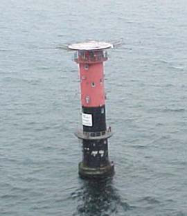
English: Fladen light, (57°13'N., 11°50'E.), equipped with a racon, is shown from a prominent floodlit tower, 26m high, standing on the NE side of Fladen, a sand bank with a least depth of 5.9 meters in teh Kattegat |
| তারিখ | |
| উৎস | http://www.nga.mil/portal/site/maritime/?epi_menuItemID=eb128c56b8e903e25b2a7fbd3227a759&epi_menuID=35ad5b8aabcefa1a0fc133443927a759&epi_baseMenuID=e106a3b5e50edce1fec24fd73927a759 Sailing Directions Enroute, Vol. 193, page 95 |
| লেখক | NGA |
লাইসেন্স প্রদান
This image is a work of the United States National Geospatial-Intelligence Agency or one of its predecessor agencies. As a work of the U.S. federal government, the image is in the public domain.
|
 |
ফাইলের ইতিহাস
যেকোনো তারিখ/সময়ে ক্লিক করে দেখুন ফাইলটি তখন কী অবস্থায় ছিল।
| তারিখ/সময় | সংক্ষেপচিত্র | মাত্রা | ব্যবহারকারী | মন্তব্য | |
|---|---|---|---|---|---|
| বর্তমান | ০৬:২৭, ১৩ আগস্ট ২০০৯ | | ২৭০ × ৩১২ (১১২ কিলোবাইট) | Ratzer | {{Information |Description={{en|1=Fladen light, (57°13'N., 11°50'E.), equipped with a racon, is shown from a prominent floodlit tower, 26m high, standing on the NE side of Fladen, a sand bank with a least depth of 5.9 meters in teh Kattegat}} |Source=ht |
সংযোগসমূহ
নিচের পৃষ্ঠা(গুলো) থেকে এই ছবিতে সংযোগ আছে:
ফাইলের বৈশ্বিক ব্যবহার
নিচের অন্যান্য উইকিগুলো এই ফাইলটি ব্যবহার করে:
- ar.wikipedia.org-এ ব্যবহার
- ca.wikipedia.org-এ ব্যবহার
- de.wikipedia.org-এ ব্যবহার
- en.wikipedia.org-এ ব্যবহার
- hr.wikipedia.org-এ ব্যবহার
- la.wikipedia.org-এ ব্যবহার
- sl.wikipedia.org-এ ব্যবহার
- sv.wikipedia.org-এ ব্যবহার
- www.wikidata.org-এ ব্যবহার