
চিত্র:Map of Izu Islands.png

এই প্রাকদর্শনের আকার: ৫৩৫ × ৬০০ পিক্সেল। অন্যান্য আকারসমূহ: ২১৪ × ২৪০ পিক্সেল | ৪২৮ × ৪৮০ পিক্সেল | ৬৮৫ × ৭৬৮ পিক্সেল | ১,২৫৭ × ১,৪০৯ পিক্সেল।
পূর্ণ রেজোলিউশন (১,২৫৭ × ১,৪০৯ পিক্সেল, ফাইলের আকার: ৬৯১ কিলোবাইট, এমআইএমই ধরন: image/png)
| এই ফাইলটি উইকিমিডিয়া কমন্স থেকে নেওয়া। সেখানের বর্ণনা পাতার বিস্তারিত নিম্নে দেখানো হলো। (সম্পাদনা)
|
সারাংশ
| বিবরণ |
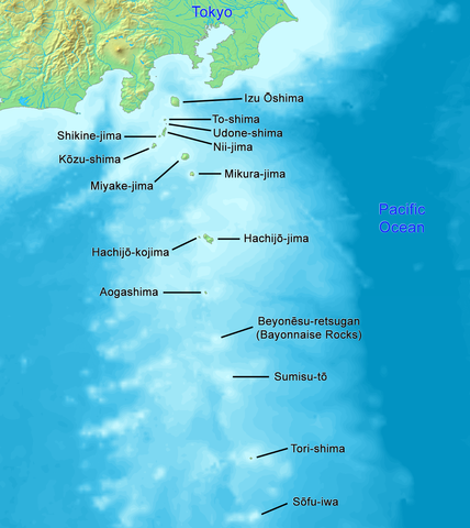
English: High quality map of the Izu Islands. This is the English (Romaji) version with Japanese names. Created with DEMIS World Map Server.
日本語: 日本語:高品質の地図、伊豆諸島。 |
| তারিখ | |
| উৎস | নিজের কাজ |
| লেখক | Artanisen |
| অন্যান্য সংস্করণ |
|

লাইসেন্স প্রদান
This image is in the public domain because it came from the site https://www.demis.nl/products/web-map-server/examples/ and was released by the copyright holder. Permission is granted to copy, distribute and/or modify this map since it is based on free of copyright images from: www.demis.nl. See also approval email on de.wp and its clarification.
|
| This work has been released into the public domain by its copyright holder, www.demis.nl. This applies worldwide. কিছু দেশে এটি আইনত সিদ্ধ নাও হতে পারে, যদি তাই হয়: www.demis.nl যে-কাউকে যেকোনো উদ্দেশ্যে, বিনাশর্তে এই কাজটি ব্যবহারের অনুমতি প্রদান করেন, যদি না সেই শর্তগুলো আইনত প্রয়োজনীয় হয়।
|

|
This map image could be re-created using vector graphics as an SVG file. This has several advantages; see Commons:Media for cleanup for more information. If an SVG form of this image is available, please upload it and afterwards replace this template with
{{vector version available|new image name}}.
It is recommended to name the SVG file “Map of Izu Islands.svg”—then the template Vector version available (or Vva) does not need the new image name parameter. |
ফাইলের ইতিহাস
যেকোনো তারিখ/সময়ে ক্লিক করে দেখুন ফাইলটি তখন কী অবস্থায় ছিল।
| তারিখ/সময় | সংক্ষেপচিত্র | মাত্রা | ব্যবহারকারী | মন্তব্য | |
|---|---|---|---|---|---|
| বর্তমান | ০১:০৪, ২৪ ডিসেম্বর ২০২১ | | ১,২৫৭ × ১,৪০৯ (৬৯১ কিলোবাইট) | Artanisen | Reverted to version as of 10:15, 2 October 2019 (UTC) reverted to names in English only, because there is a separate Japanese map |
| ০৭:২২, ২১ অক্টোবর ২০১৯ |  | ১,২৫৭ × ১,৪০৯ (৭৭১ কিলোবাইট) | Artanisen | Added Japanese kanji of the island names and thinner black lines. | |
| ১০:১৫, ২ অক্টোবর ২০১৯ |  | ১,২৫৭ × ১,৪০৯ (৬৯১ কিলোবাইট) | Artanisen | English: High quality map of the Izu Islands. Created with DEMIS World Map Server. 日本語:高品質の地図、伊豆諸島。 | |
| ১৪:৫১, ৫ অক্টোবর ২০০৬ |  | ৩০০ × ৪০০ (৩২ কিলোবাইট) | Tdk~commonswiki | Map of Izu Islands. Created with DEMIS World Map Server.{{demis-pd}} |
সংযোগসমূহ
নিচের পৃষ্ঠা(গুলো) থেকে এই ছবিতে সংযোগ আছে:
ফাইলের বৈশ্বিক ব্যবহার
নিচের অন্যান্য উইকিগুলো এই ফাইলটি ব্যবহার করে:
- ar.wikipedia.org-এ ব্যবহার
- az.wikipedia.org-এ ব্যবহার
- ca.wikipedia.org-এ ব্যবহার
- ceb.wikipedia.org-এ ব্যবহার
- ckb.wikipedia.org-এ ব্যবহার
- cs.wikipedia.org-এ ব্যবহার
- da.wikipedia.org-এ ব্যবহার
- el.wikipedia.org-এ ব্যবহার
- en.wikipedia.org-এ ব্যবহার
- Geography of Japan
- Tokyo
- List of islands of Japan
- Devil's Sea
- Izu Islands
- Nii-jima
- Kōzu-shima
- Portal:Japan
- Shikine-jima
- Izu Ōshima
- Mikura-jima
- Lot's Wife (crag)
- Aogashima
- Tori-shima (Izu Islands)
- Hachijō-kojima
- Smith Island (Japan)
- Inamba-jima
- Udone-shima
- Ōnohara Islands
- Bayonnaise Rocks
- Hachijō language
- Jinai-tō
- List of governors of the Nanpō Islands
- Seven Islands of Izu
- en.wikibooks.org-এ ব্যবহার
- en.wikivoyage.org-এ ব্যবহার
- eo.wikipedia.org-এ ব্যবহার
- es.wikipedia.org-এ ব্যবহার
এই ফাইলের অন্যান্য বৈশ্বিক ব্যবহার দেখুন।