
চিত্র:Lincoln Home Site, Site Plan, Eighth Street, Springfield, Sangamon County, IL HABS ILL,84-SPRIF,2- (sheet 1 of 1).tif

এই TIF ফাইলের জন্য এই JPG প্রাকদর্শনের আকার: ৮০০ × ৫৩১ পিক্সেল। অন্যান্য আকারসমূহ: ৩২০ × ২১৩ পিক্সেল | ৬৪০ × ৪২৫ পিক্সেল | ১,০২৪ × ৬৮০ পিক্সেল | ১,২৮০ × ৮৫০ পিক্সেল | ২,৫৬০ × ১,৭০১ পিক্সেল | ১৪,৫০০ × ৯,৬৩২ পিক্সেল।
পূর্ণ রেজোলিউশন (১৪,৫০০ × ৯,৬৩২ পিক্সেল, ফাইলের আকার: ১.২২ মেগাবাইট, এমআইএমই ধরন: image/tiff)
| এই ফাইলটি উইকিমিডিয়া কমন্স থেকে নেওয়া। সেখানের বর্ণনা পাতার বিস্তারিত নিম্নে দেখানো হলো। (সম্পাদনা)
|
সারাংশ
| সতর্কীকরণ | মূল ফাইলে বড় সংখ্যার পিক্সেল আছে এবং এটি সঠিকভাবে লোড নাও হতে পারে বা আপনার ব্রাউজার নিশ্চল করে দিতে। |
|---|
| HABS ILL,84-SPRIF,2- (sheet 1 of 1) - Lincoln Home Site, Site Plan, Eighth Street, Springfield, Sangamon County, IL | ||||
|---|---|---|---|---|
| শিরোনাম |
HABS ILL,84-SPRIF,2- (sheet 1 of 1) - Lincoln Home Site, Site Plan, Eighth Street, Springfield, Sangamon County, IL |
|||
| দেখানো জায়গা | Illinois; Sangamon County; Springfield | |||
| তারিখ | Documentation compiled after 1933 | |||
| আকার | 24 x 36 in. (D size) | |||
| বর্তমান অবস্থান |
Library of Congress Prints and Photographs Division Washington, D.C. 20540 USA http://hdl.loc.gov/loc.pnp/pp.print |
|||
| সংযোজন সংখ্যা |
HABS ILL,84-SPRIF,2- (sheet 1 of 1) |
|||
| স্বীকৃতি রেখা |
|
|||
| টীকা |
|
|||
| তথ্যসূত্র |
|
|||
| উৎস | https://www.loc.gov/pictures/item/il0382.sheet.00001a | |||
| অনুমতি (এ ফাইলের পুনঃব্যবহার) |
|
|||
| অন্যান্য সংস্করণ |
.png) |
|||

| বস্তুর অবস্থান | | এটি এবং অন্যান্য ছবি তাদের অবস্থানের উপর: ওপেনস্ট্রিটম্যাপ |
|---|
ফাইলের ইতিহাস
যেকোনো তারিখ/সময়ে ক্লিক করে দেখুন ফাইলটি তখন কী অবস্থায় ছিল।
| তারিখ/সময় | সংক্ষেপচিত্র | মাত্রা | ব্যবহারকারী | মন্তব্য | |
|---|---|---|---|---|---|
| বর্তমান | ২২:৩৮, ১৬ জুলাই ২০১৪ | 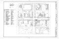 | ১৪,৫০০ × ৯,৬৩২ (১.২২ মেগাবাইট) | Fæ | GWToolset: Creating mediafile for Fæ. HABS 11 July 2014 (1001:1200) |
সংযোগসমূহ
নিচের পৃষ্ঠা(গুলো) থেকে এই ছবিতে সংযোগ আছে:
ফাইলের বৈশ্বিক ব্যবহার
নিচের অন্যান্য উইকিগুলো এই ফাইলটি ব্যবহার করে:
- en.wikipedia.org-এ ব্যবহার
- ha.wikipedia.org-এ ব্যবহার