
চিত্র:Gulf of Tonkin location.gif
এর চেয়ে বেশি রেজোলিউশন লভ্য নয়।
Gulf_of_Tonkin_location.gif (৫০০ × ৫০০ পিক্সেল, ফাইলের আকার: ৯০ কিলোবাইট, এমআইএমই ধরন: image/gif)
| এই ফাইলটি উইকিমিডিয়া কমন্স থেকে নেওয়া। সেখানের বর্ণনা পাতার বিস্তারিত নিম্নে দেখানো হলো। (সম্পাদনা)
|

|
This locator map image could be re-created using vector graphics as an SVG file. This has several advantages; see Commons:Media for cleanup for more information. If an SVG form of this image is available, please upload it and afterwards replace this template with
{{vector version available|new image name}}.
It is recommended to name the SVG file “Gulf of Tonkin location.svg”—then the template Vector version available (or Vva) does not need the new image name parameter. |
| বিবরণ |
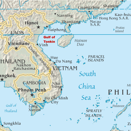
English: Map showing the location of the Gulf of Tonkin in the South China Sea |
||
| তারিখ | ৩১ অক্টোবর ২০০৫ (মূল আপলোডের তারিখ) | ||
| উৎস | My original artwork based on a public domain map from the CIA World Factbook. | ||
| লেখক | মূল আপলোডকারী ছিলেন ইংরেজি উইকিপিডিয়া-এর DanMS | ||
| অনুমতি (এ ফাইলের পুনঃব্যবহার) |
|
মূল আপলোড লগ
মূল বিবরণ পাতাটি এখানে ছিল। নিম্নলিখিত সকল ব্যবহারকারীর নাম en.wikipedia-এ উল্লেখ করা ছিল।
- 2005-11-02 16:39 DanMS 500×500× (92188 bytes) Map showing the location of the Gulf of Tonkin in the South China Sea. My original artwork based on a public domain map from the CIA World Factbook. This is a modification of my earlier file by the same name. {{pd-user|DanMS}}
- 2005-10-31 21:55 DanMS 500×500× (89358 bytes) Map showing the location of the Gulf of Tonkin in the South China Sea. My original artwork based on a public domain map from the CIA World Factbook. {{pd-user|DanMS}}
ফাইলের ইতিহাস
যেকোনো তারিখ/সময়ে ক্লিক করে দেখুন ফাইলটি তখন কী অবস্থায় ছিল।
| তারিখ/সময় | সংক্ষেপচিত্র | মাত্রা | ব্যবহারকারী | মন্তব্য | |
|---|---|---|---|---|---|
| বর্তমান | ১১:২৯, ১৫ মে ২০১০ | | ৫০০ × ৫০০ (৯০ কিলোবাইট) | Urdangaray | {{Information |Description={{en|Map showing the location of the Gulf of Tonkin in the South China Sea. My original artwork based on a public domain map from the CIA World Factbook.}} |Source=Transferred from [http://en.wikipedia.org en.wikipedia] |Date={{ |
সংযোগসমূহ
নিচের পৃষ্ঠা(গুলো) থেকে এই ছবিতে সংযোগ আছে:
ফাইলের বৈশ্বিক ব্যবহার
নিচের অন্যান্য উইকিগুলো এই ফাইলটি ব্যবহার করে:
- af.wikipedia.org-এ ব্যবহার
- ar.wikipedia.org-এ ব্যবহার
- bg.wikipedia.org-এ ব্যবহার
- bs.wikipedia.org-এ ব্যবহার
- cs.wikipedia.org-এ ব্যবহার
- cy.wikipedia.org-এ ব্যবহার
- de.wikipedia.org-এ ব্যবহার
- en.wikipedia.org-এ ব্যবহার
- es.wikipedia.org-এ ব্যবহার
- fa.wikipedia.org-এ ব্যবহার
- fi.wikipedia.org-এ ব্যবহার
- fr.wikipedia.org-এ ব্যবহার
- fy.wikipedia.org-এ ব্যবহার
- he.wikipedia.org-এ ব্যবহার
- hi.wikipedia.org-এ ব্যবহার
- hu.wikipedia.org-এ ব্যবহার
- id.wikipedia.org-এ ব্যবহার
- ilo.wikipedia.org-এ ব্যবহার
- it.wikipedia.org-এ ব্যবহার
- ja.wikipedia.org-এ ব্যবহার
- km.wikipedia.org-এ ব্যবহার
- ky.wikipedia.org-এ ব্যবহার
- mk.wikipedia.org-এ ব্যবহার
- nds-nl.wikipedia.org-এ ব্যবহার
- nl.wikipedia.org-এ ব্যবহার
- nn.wikipedia.org-এ ব্যবহার
- pl.wikipedia.org-এ ব্যবহার
- sh.wikipedia.org-এ ব্যবহার
- sl.wikipedia.org-এ ব্যবহার
- sr.wikipedia.org-এ ব্যবহার
- th.wikipedia.org-এ ব্যবহার
- ur.wikipedia.org-এ ব্যবহার
- vi.wikipedia.org-এ ব্যবহার
- war.wikipedia.org-এ ব্যবহার
- zh.wikipedia.org-এ ব্যবহার