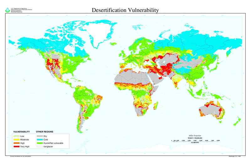
চিত্র:Desertification map.png

এই প্রাকদর্শনের আকার: ৮০০ × ৫১৮ পিক্সেল। অন্যান্য আকারসমূহ: ৩২০ × ২০৭ পিক্সেল | ৬৪০ × ৪১৪ পিক্সেল | ১,০২৪ × ৬৬৩ পিক্সেল | ১,২৮০ × ৮২৮ পিক্সেল | ২,৫৬০ × ১,৬৫৬ পিক্সেল | ৬,৮০০ × ৪,৪০০ পিক্সেল।
পূর্ণ রেজোলিউশন (৬,৮০০ × ৪,৪০০ পিক্সেল, ফাইলের আকার: ১.০৪ মেগাবাইট, এমআইএমই ধরন: image/png)
ফাইলের ইতিহাস
যেকোনো তারিখ/সময়ে ক্লিক করে দেখুন ফাইলটি তখন কী অবস্থায় ছিল।
| তারিখ/সময় | সংক্ষেপচিত্র | মাত্রা | ব্যবহারকারী | মন্তব্য | |
|---|---|---|---|---|---|
| বর্তমান | ১১:০১, ২৭ মার্চ ২০২২ |  | ৬,৮০০ × ৪,৪০০ (১.০৪ মেগাবাইট) | No.cilepogača | Reverted to version as of 00:12, 8 November 2006 (UTC) |
| ০৫:১১, ৮ নভেম্বর ২০০৬ |  | ১,৭০০ × ১,১০০ (৫৫৮ কিলোবাইট) | Paleorthid | {{Information |Description=Global Desertification Vulnerability Map |Source=http://soils.usda.gov/use/worldsoils/mapindex/desert-map.zip |Date=1998 |Author=USDA employee |Permission=This image is a work of a United States Department of Agriculture employe | |
| ০০:১২, ৮ নভেম্বর ২০০৬ |  | ৬,৮০০ × ৪,৪০০ (১.০৪ মেগাবাইট) | Paleorthid | {{Information |Description=Global Desertification Vulnerability Map |Source=http://soils.usda.gov/use/worldsoils/mapindex/desert-map.zip |Date=1998 |Author=USDA employee |Permission=This image is a work of a United States Department of Agriculture employe |
সংযোগসমূহ
নিচের পৃষ্ঠা(গুলো) থেকে এই ছবিতে সংযোগ আছে:
ফাইলের বৈশ্বিক ব্যবহার
নিচের অন্যান্য উইকিগুলো এই ফাইলটি ব্যবহার করে:
- ar.wikipedia.org-এ ব্যবহার
- az.wikipedia.org-এ ব্যবহার
- bg.wikipedia.org-এ ব্যবহার
- bo.wikipedia.org-এ ব্যবহার
- ca.wikinews.org-এ ব্যবহার
- ckb.wikipedia.org-এ ব্যবহার
- cs.wikipedia.org-এ ব্যবহার
- da.wikipedia.org-এ ব্যবহার
- de.wikipedia.org-এ ব্যবহার
- de.wiktionary.org-এ ব্যবহার
- el.wikipedia.org-এ ব্যবহার
- en.wikipedia.org-এ ব্যবহার
- eo.wikipedia.org-এ ব্যবহার
- es.wikipedia.org-এ ব্যবহার
- eu.wikipedia.org-এ ব্যবহার
- fa.wikipedia.org-এ ব্যবহার
- fi.wikipedia.org-এ ব্যবহার
- fr.wikipedia.org-এ ব্যবহার
- fr.wikinews.org-এ ব্যবহার
- ga.wikipedia.org-এ ব্যবহার
- he.wikipedia.org-এ ব্যবহার
- hu.wikipedia.org-এ ব্যবহার
- hy.wikipedia.org-এ ব্যবহার
- id.wikipedia.org-এ ব্যবহার
- is.wikipedia.org-এ ব্যবহার
- it.wikipedia.org-এ ব্যবহার
- ja.wikipedia.org-এ ব্যবহার
- ko.wikipedia.org-এ ব্যবহার
এই ফাইলের অন্যান্য বৈশ্বিক ব্যবহার দেখুন।

