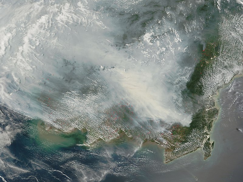
চিত্র:Borneo fires October 2006.jpg

এই প্রাকদর্শনের আকার: ৮০০ × ৬০০ পিক্সেল। অন্যান্য আকারসমূহ: ৩২০ × ২৪০ পিক্সেল | ৬৪০ × ৪৮০ পিক্সেল | ১,০২৪ × ৭৬৮ পিক্সেল | ১,২৮০ × ৯৬০ পিক্সেল | ২,৫৬০ × ১,৯২০ পিক্সেল | ৪,০০০ × ৩,০০০ পিক্সেল।
পূর্ণ রেজোলিউশন (৪,০০০ × ৩,০০০ পিক্সেল, ফাইলের আকার: ১.৯৪ মেগাবাইট, এমআইএমই ধরন: image/jpeg)
ফাইলের ইতিহাস
যেকোনো তারিখ/সময়ে ক্লিক করে দেখুন ফাইলটি তখন কী অবস্থায় ছিল।
| তারিখ/সময় | সংক্ষেপচিত্র | মাত্রা | ব্যবহারকারী | মন্তব্য | |
|---|---|---|---|---|---|
| বর্তমান | ০৯:৩০, ৯ অক্টোবর ২০০৬ |  | ৪,০০০ × ৩,০০০ (১.৯৪ মেগাবাইট) | NSLE-Chacor | {{Information |Description= Fires on Borneo Thick smoke hung over the island of Borneo when the Moderate Resolution Imaging Spectroradiometer (MODIS) on NASA’s Terra satellite passed overhead on October 5, 2006. The sensor detected scores of fires (loc |
সংযোগসমূহ
নিচের পৃষ্ঠা(গুলো) থেকে এই ছবিতে সংযোগ আছে:
ফাইলের বৈশ্বিক ব্যবহার
নিচের অন্যান্য উইকিগুলো এই ফাইলটি ব্যবহার করে:
- ar.wikipedia.org-এ ব্যবহার
- as.wikipedia.org-এ ব্যবহার
- ba.wikipedia.org-এ ব্যবহার
- de.wikipedia.org-এ ব্যবহার
- en.wikipedia.org-এ ব্যবহার
- ASEAN
- Illegal logging
- ASEAN Agreement on Transboundary Haze Pollution
- Peat swamp forest
- Borneo peat swamp forests
- 2006 Southeast Asian haze
- Mega Rice Project
- Deforestation in Indonesia
- User:Montyhasan/sandbox
- User:Mentoroso/sandbox2
- User:Lyons34/sandbox
- User:Monruw/sandbox
- Wikipedia:In the news/Posted/October 2006
- en.wikinews.org-এ ব্যবহার
- es.wikipedia.org-এ ব্যবহার
- fa.wikipedia.org-এ ব্যবহার
- ha.wikipedia.org-এ ব্যবহার
- hr.wikipedia.org-এ ব্যবহার
- id.wikipedia.org-এ ব্যবহার
- ig.wikipedia.org-এ ব্যবহার
- it.wikipedia.org-এ ব্যবহার
- mn.wikipedia.org-এ ব্যবহার
- ms.wikipedia.org-এ ব্যবহার
- ru.wikipedia.org-এ ব্যবহার
- sh.wikipedia.org-এ ব্যবহার
- sr.wikipedia.org-এ ব্যবহার
- th.wikipedia.org-এ ব্যবহার
- uk.wikipedia.org-এ ব্যবহার
- ur.wikipedia.org-এ ব্যবহার
- uz.wikipedia.org-এ ব্যবহার
- vi.wikipedia.org-এ ব্যবহার
এই ফাইলের অন্যান্য বৈশ্বিক ব্যবহার দেখুন।


