
চিত্র:Jugo-slavia, 1919.png

পূর্ণ রেজোলিউশন (৩,২৮৬ × ৩,৪২৪ পিক্সেল, ফাইলের আকার: ৩.০২ মেগাবাইট, এমআইএমই ধরন: image/png)
| এই ফাইলটি উইকিমিডিয়া কমন্স থেকে নেওয়া। সেখানের বর্ণনা পাতার বিস্তারিত নিম্নে দেখানো হলো। (সম্পাদনা)
|
সারাংশ
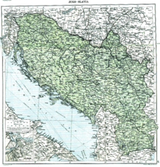
Map of Yugoslavia (Kingdom of Serbs, Croats and Slovenes) in 1919, in the aftermath of World War I, after the dissolution of Austria-Hungary and the incorporation of Montenegro and before the treaties of Neuilly-sur-Seine, Trianon and Rapallo. Published in 1920 by the London Geographical Institute (note that this map does not reflect any internationally established borders or armistice lines - it only reflects the opinion of the researchers from the London Geographical Institute about how the final borders will look after the Paris Peace Conference)
This uploaded map is a photoshopped version of the original image located at hipkiss.org. According to the site, there are no copyrights to this map.
লাইসেন্স প্রদান
This image (or other media file) is in the public domain because its copyright has expired and its author is anonymous.
This applies to the European Union and those countries with a copyright term of 70 years after the work was made available to the public and the author never disclosed their identity. Important: Always mention where the image comes from, as far as possible, and make sure the author never claimed authorship. Note: In Germany and possibly other countries, certain anonymous works published before July 1, 1995 are copyrighted until 70 years after the death of the author. See Übergangsrecht. Please use this template only if the author never claimed authorship or their authorship never became public in any other way. If the work is anonymous or pseudonymous (e.g., published only under a corporate or organization's name), use this template for images published more than 70 years ago.
For a work made available to the public in the United Kingdom, please use Template:PD-UK-unknown instead.
|
এই কাজটি মার্কিন যুক্তরাষ্ট্রে পাবলিক ডোমেইনে রয়েছে কারণ এটি ১ জানুয়ারি, ১৯২৯ সালের আগে প্রকাশিত (অথবা মার্কিন কপিরাইট অফিসে নিবন্ধিত) হয়েছিল।
কমন্সে রাখার অনুমতিতে পাবলিক ডোমেইনের কাজ অবশ্যই কাজের উৎস দেশ ও মার্কিন যুক্তরাষ্ট্র উভয় দেশে কপিরাইট মুক্ত হতে হয়। যদি কাজটি যুক্তরাষ্ট্রের না হয়, তবে উৎস দেশের কপিরাইট অবস্থা নির্দেশের জন্য ফাইলে অবশ্যই একটি অতিরিক্ত কপিরাইট ট্যাগ থাকতে হবে।
|
মূল আপলোড লগ
- 2008-07-03 23:29 Jklamo 3286×3424× (3168788 bytes) more photoshopped
- 2008-04-10 19:36 MaGioZal 3348×3500× (7196870 bytes) Map of [[Yugoslavia]] ([[Kingdom of Serbs, Croats and Slovenes]]) in [[1919]], showing the provisional borders in the [[aftermath of World War II]], after the dissolution of [[Austria-Hungary]] and the incorporation of [[Kingdom of Montenegro|Montenegro]]
ফাইলের ইতিহাস
যেকোনো তারিখ/সময়ে ক্লিক করে দেখুন ফাইলটি তখন কী অবস্থায় ছিল।
| তারিখ/সময় | সংক্ষেপচিত্র | মাত্রা | ব্যবহারকারী | মন্তব্য | |
|---|---|---|---|---|---|
| বর্তমান | ০০:১২, ১৫ জানুয়ারি ২০১২ | | ৩,২৮৬ × ৩,৪২৪ (৩.০২ মেগাবাইট) | OgreBot | (BOT): Reverting to most recent version before archival |
| ০০:১২, ১৫ জানুয়ারি ২০১২ |  | ৩,৩৪৮ × ৩,৫০০ (৬.৮৬ মেগাবাইট) | OgreBot | (BOT): Uploading old version of file from en.wikipedia; originally uploaded on 2008-04-10 19:36:04 by MaGioZal | |
| ০৮:২২, ২৭ মে ২০১১ |  | ৩,২৮৬ × ৩,৪২৪ (৩.০২ মেগাবাইট) | Tat1642 | ==Description== Map of Yugoslavia (Kingdom of Serbs, Croats and Slovenes) in 1919, in the aftermath of World War I, after the dissolution of Austria-Hungary and the incorporation of Montenegro and before the t |
সংযোগসমূহ
নিচের পৃষ্ঠা(গুলো) থেকে এই ছবিতে সংযোগ আছে:
ফাইলের বৈশ্বিক ব্যবহার
নিচের অন্যান্য উইকিগুলো এই ফাইলটি ব্যবহার করে:
- ca.wikipedia.org-এ ব্যবহার
- cs.wikipedia.org-এ ব্যবহার
- en.wikipedia.org-এ ব্যবহার
- et.wikipedia.org-এ ব্যবহার
- it.wikipedia.org-এ ব্যবহার
- ru.wikipedia.org-এ ব্যবহার
- sk.wikipedia.org-এ ব্যবহার
- th.wikipedia.org-এ ব্যবহার
- vi.wikipedia.org-এ ব্যবহার