
চিত্র:Rzeczpospolita.png

এই প্রাকদর্শনের আকার: ৭৬৫ × ৬০০ পিক্সেল। অন্যান্য আকারসমূহ: ৩০৬ × ২৪০ পিক্সেল | ৬১২ × ৪৮০ পিক্সেল | ৯৮০ × ৭৬৮ পিক্সেল | ১,২৮০ × ১,০০৪ পিক্সেল | ২,০০০ × ১,৫৬৮ পিক্সেল।
পূর্ণ রেজোলিউশন (২,০০০ × ১,৫৬৮ পিক্সেল, ফাইলের আকার: ৩৩২ কিলোবাইট, এমআইএমই ধরন: image/png)
| এই ফাইলটি উইকিমিডিয়া কমন্স থেকে নেওয়া। সেখানের বর্ণনা পাতার বিস্তারিত নিম্নে দেখানো হলো। (সম্পাদনা)
|
সারাংশ
| বিবরণ |
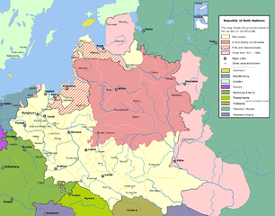
English: Commonwealth of Both Nations at the peak of its strength. The areas marked with light pink were lost to:
|
| তারিখ | |
| উৎস | নিজের কাজ |
| লেখক | Halibutt |
| অনুমতি (এ ফাইলের পুনঃব্যবহার) |
GFDL, see below |
| অন্যান্য সংস্করণ |
|

|
This historical map image could be re-created using vector graphics as an SVG file. This has several advantages; see Commons:Media for cleanup for more information. If an SVG form of this image is available, please upload it and afterwards replace this template with
{{vector version available|new image name}}.
It is recommended to name the SVG file “Rzeczpospolita.svg”—then the template Vector version available (or Vva) does not need the new image name parameter. |
লাইসেন্স প্রদান
Since the legal status of the above comment has been questioned, I hereby grant anyone the right to treat it as either a standard copyright notice, invariant section, legal statement, legal advice, friendly suggestion or a mere comment, depending on his or hers own choice. |
|

History of Poland
The following is a list of maps created by Halibutt and uploaded to commons, as well as their present and projected derivatives.
| Parent Image | Image | Description | |||||||||||
|---|---|---|---|---|---|---|---|---|---|---|---|---|---|
| Maps by Halibutt | |||||||||||||
| Image:Rzeczpospolita.png | Image:Rzeczpospolita.png | The Republic in 17th and 18th century | |||||||||||
| Image:Rzeczpospolita 1600.png | The Republic after the Treaty of Dywilino | ||||||||||||
| Image:Rzeczpospolita voivodships.png | Voivodships of The Republic | ||||||||||||
| Image:Rzeczpospolita_Potop.png | The Republic during The Deluge and Chmielnicki Uprising, with major battles of the era marked | ||||||||||||
| Magnates and their lands and domains | |||||||||||||
| 1st • 2nd • 3rd | Partitions of Poland | ||||||||||||
| War of the constitution | |||||||||||||
| Image:Rzeczpospolita.xcf | SOURCE FILE - GIMP format | ||||||||||||
| Image:Poland 1939.png | Image:Poland 1939.png | Poland in 1939 | |||||||||||
| Image:Dywizje wrzesien 1.png | Order of Battle on September 1st, during the Polish Defence War of 1939 | ||||||||||||
| Image:Poland 1939.xcf | SOURCE FILE - GIMP format | ||||||||||||
| Image:Polska kontur bialy.png | Image:Polska kontur bialy.png | Contour map of Poland AD 1999, for use with various locator maps | |||||||||||
| Image:Rzeczpospolita 1923.png | Image:Rzeczpospolita 1923.png | Map of Poland 1918-1939, currently under development | |||||||||||
| Image:PBW March 1919.png | Polish-Bolshevik War - fronts in March of 1919 | ||||||||||||
| Image:PBW December 1919.png | Polish-Bolshevik War - fronts in December of 1919 | ||||||||||||
| Image:PBW June 1920.png | Polish-Bolshevik War - fronts in July of 1920 | ||||||||||||
| Image:PBW August 1920.png | Polish-Bolshevik War - fronts in August of 1920 | ||||||||||||
| Polish Defence War of 1939 | |||||||||||||
| Polish areas annexed by Germany, Lithuania, Slovakia and the Soviet Union | |||||||||||||
| German concentration camps in Poland | |||||||||||||
| Curzon line | |||||||||||||
| Major battles of the Polish-Bolshevik War | |||||||||||||
| names • no names | Polish/Czechoslovak/Lithuanian/German/Ukrainian claims in 1920's | ||||||||||||
| Image:Rzeczpospolita Central Lithuania.png | Central Lithuania | ||||||||||||
| Image:Rzeczpospolita Lithuania claims.png | Central Lithuania as compared with other Lithuanian claims | ||||||||||||
| Image:Rzeczpospolita 1789-1920.png | Post-1922 borders compared with the territory of Poland before the partitions | ||||||||||||
| Warsaw Uprising and the Operation Tempest | |||||||||||||
| Poland partitioned between the Soviets and the Germans | |||||||||||||
| Image:Rzeczpospolita 1939 Polish divisions.png | Polish divisions on September 1, 1939 | ||||||||||||
| Home Army inspectorates | |||||||||||||
| Image:Rzeczpospolita 1922.xcf | SOURCE FILE - GIMP format | ||||||||||||
| Image:Rzeczpospolita 1937.svg | Vector version!!!! | layered version available on request | |||||||||||

|
This image (or all images in this category) uses inside labels or attached captions in a specific script or language and should be converted to a language neutral form. This would allow its use in all Wikimedia projects and, more importantly, all Wikimedia languages.
|
ফাইলের ইতিহাস
যেকোনো তারিখ/সময়ে ক্লিক করে দেখুন ফাইলটি তখন কী অবস্থায় ছিল।
| তারিখ/সময় | সংক্ষেপচিত্র | মাত্রা | ব্যবহারকারী | মন্তব্য | |
|---|---|---|---|---|---|
| বর্তমান | ১৪:৩৭, ৬ মে ২০১৬ | | ২,০০০ × ১,৫৬৮ (৩৩২ কিলোবাইট) | Julieta39 | Cosmetic changes: see sources in the discussion page of today. |
| ১০:৪০, ৮ ডিসেম্বর ২০০৯ |  | ২,০০০ × ১,৫৬৮ (২২১ কিলোবাইট) | Tryphon | Removed watermark. | |
| ১৯:৩৪, ১৩ ডিসেম্বর ২০০৪ |  | ২,০০০ × ১,৫৬৮ (৩০৪ কিলোবাইট) | Halibutt | Ok, final version at last (unless you have some more comments or suggestions) | |
| ০৭:৪৭, ১০ ডিসেম্বর ২০০৪ |  | ২,০০০ × ১,৫৬৮ (২৯৭ কিলোবাইট) | Halibutt | final version? | |
| ০১:৩৬, ১০ ডিসেম্বর ২০০৪ |  | ২,০০০ × ১,৫৬৮ (১৯৩ কিলোবাইট) | Halibutt | new update | |
| ০৩:২৩, ৮ ডিসেম্বর ২০০৪ |  | ২,০০০ × ১,৫৬৮ (১৪১ কিলোবাইট) | Halibutt | Commonwealth of Both Nations at the peak of its strength<br>Beta version of a map by Halibutt<br>{{User:Halibutt/GFDL}} |
সংযোগসমূহ
এই ফাইল ব্যবহার করে এমন কোনো পাতা নেই।
ফাইলের বৈশ্বিক ব্যবহার
নিচের অন্যান্য উইকিগুলো এই ফাইলটি ব্যবহার করে:
- ar.wikipedia.org-এ ব্যবহার
- arz.wikipedia.org-এ ব্যবহার
- azb.wikipedia.org-এ ব্যবহার
- bg.wikipedia.org-এ ব্যবহার
- br.wikipedia.org-এ ব্যবহার
- ca.wikipedia.org-এ ব্যবহার
- da.wikipedia.org-এ ব্যবহার
- de.wikipedia.org-এ ব্যবহার
- de.wikibooks.org-এ ব্যবহার
- en.wikipedia.org-এ ব্যবহার
- John III Sobieski
- User:Halibutt
- Stanisław Koniecpolski
- Wikipedia:Today's featured article/January 2005
- Wikipedia:Today's featured article/January 11, 2005
- Talk:Eastern and Western Vilnius regions
- Talk:Russian Mennonites
- User:Art Serebren
- User talk:Mikołajski
- User:Cyborg Ninja/sandbox
- User:Falcaorib/Poland-Lithuania
- eo.wikipedia.org-এ ব্যবহার
- et.wikipedia.org-এ ব্যবহার
- fi.wikipedia.org-এ ব্যবহার
- fr.wikipedia.org-এ ব্যবহার
- gl.wikipedia.org-এ ব্যবহার
- hr.wikipedia.org-এ ব্যবহার
- hsb.wikipedia.org-এ ব্যবহার
- hu.wikipedia.org-এ ব্যবহার
- id.wikipedia.org-এ ব্যবহার
- it.wikipedia.org-এ ব্যবহার
- ja.wikipedia.org-এ ব্যবহার
এই ফাইলের অন্যান্য বৈশ্বিক ব্যবহার দেখুন।