
চিত্র:Tabaqah assad.jpg
এই প্রাকদর্শনের আকার: ৫৯২ × ৬০০ পিক্সেল। অন্যান্য আকারসমূহ: ২৩৭ × ২৪০ পিক্সেল | ৬৩১ × ৬৩৯ পিক্সেল।
পূর্ণ রেজোলিউশন (৬৩১ × ৬৩৯ পিক্সেল, ফাইলের আকার: ২৩৬ কিলোবাইট, এমআইএমই ধরন: image/jpeg)
| এই ফাইলটি উইকিমিডিয়া কমন্স থেকে নেওয়া। সেখানের বর্ণনা পাতার বিস্তারিত নিম্নে দেখানো হলো। (সম্পাদনা)
|
সারাংশ
| বিবরণ |
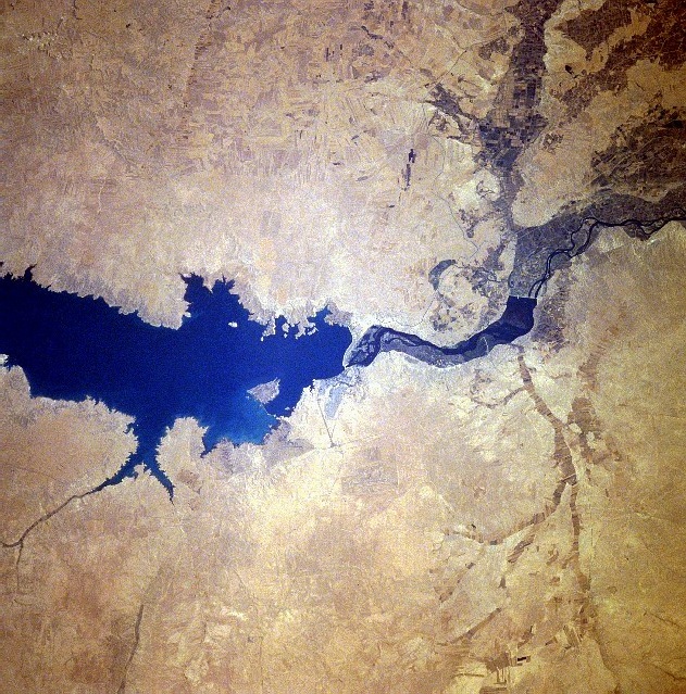
سد الفرات وبحيرة الأسد من الفضاء كانون الثاني 1996 English: Completed in 1973, the Tabaqah Dam (center of image) on the Euphrates River can be seen in this near-nadir view. The Tabaqah Dam is an earth filled dam nearly 197 feet (60 meters) high and 3 miles (5 km) long. The dam holds the waters of Lake Assad (center to left center of the image), a 50-mile (80 km) long and 5-mile (8 km) wide reservoir. Lake Assad and the Tabaqah Dam have not only provided increased hydroelectric power but the lake has doubled Syria’s irrigated land. Actual crop production has not reached the goals set by the Syrian government due to a number of problems including the gypsum subsoil of the region, and whether or not farmers could be attracted back to this scarsely populated area from urban areas or more crowded agricultural areas in other parts of the country. Also the water levels within Lake Assad remain low due mostly in part to construction of the Keban and Ataturk Dams in Turkey, which have reduced the water flow of the Euphrates River in Syria. |
| তারিখ | |
| উৎস | http://eol.jsc.nasa.gov/sseop/EFS/photoinfo.pl?PHOTO=STS078-740-83 , http://upload.wikimedia.org/wikipedia/en/c/cf/Tabaqah_assad.jpg |
| লেখক | NASA |
This image or video was catalogued by one of the centers of the United States National Aeronautics and Space Administration (NASA) under Photo ID: STS078-740-83. This tag does not indicate the copyright status of the attached work. A normal copyright tag is still required. See Commons:Licensing. Other languages:
|
লাইসেন্স প্রদান
| এই ফাইলটি পাবলিক ডোমেইনে আছে কারণ এটি শুধুমাত্র নাসা কর্তৃক নির্মিত হয়েছিল। নাসার কপিরাইট নীতি হচ্ছে যে "নাসা কর্তৃক উল্লেখ না থাকলে নাসার উপাদান কপিরাইট দ্বারা সুরক্ষিত নয়"। (Template:PD-USGov, নাসার কপিরাইট নীতির পাতা অথবা জেপিএল চিত্র ব্যবহারের নীতি দেখুন।) | ||
 |
সতর্কবার্তা:
|
ফাইলের ইতিহাস
যেকোনো তারিখ/সময়ে ক্লিক করে দেখুন ফাইলটি তখন কী অবস্থায় ছিল।
| তারিখ/সময় | সংক্ষেপচিত্র | মাত্রা | ব্যবহারকারী | মন্তব্য | |
|---|---|---|---|---|---|
| বর্তমান | ০৮:৪৫, ৩ ফেব্রুয়ারি ২০১০ | | ৬৩১ × ৬৩৯ (২৩৬ কিলোবাইট) | Rehman | Flipped to align according to directions |
| ২১:০৯, ২৮ অক্টোবর ২০০৭ |  | ৬৩১ × ৬৩৯ (২০০ কিলোবাইট) | Amir syria | {{Information |Description=سد الفرات |Source=http://eol.jsc.nasa.gov/sseop/EFS/photoinfo.pl?PHOTO=STS078-740-83 , http://upload.wikimedia.org/wikipedia/en/c/cf/Tabaqah_assad.jpg |Date= |Author= |Permission= |other_versions= }} |
সংযোগসমূহ
ফাইলের বৈশ্বিক ব্যবহার
নিচের অন্যান্য উইকিগুলো এই ফাইলটি ব্যবহার করে:
- ar.wikipedia.org-এ ব্যবহার
- arz.wikipedia.org-এ ব্যবহার
- be.wikipedia.org-এ ব্যবহার
- ca.wikipedia.org-এ ব্যবহার
- ceb.wikipedia.org-এ ব্যবহার
- de.wikipedia.org-এ ব্যবহার
- en.wikipedia.org-এ ব্যবহার
- es.wikipedia.org-এ ব্যবহার
- fa.wikipedia.org-এ ব্যবহার
- fr.wikipedia.org-এ ব্যবহার
- he.wikipedia.org-এ ব্যবহার
- hy.wikipedia.org-এ ব্যবহার
- id.wikipedia.org-এ ব্যবহার
- it.wikipedia.org-এ ব্যবহার
- ko.wikipedia.org-এ ব্যবহার
- lt.wikipedia.org-এ ব্যবহার
- nl.wikipedia.org-এ ব্যবহার
- nn.wikipedia.org-এ ব্যবহার
- no.wikipedia.org-এ ব্যবহার
- pl.wikipedia.org-এ ব্যবহার
- pt.wikipedia.org-এ ব্যবহার
- ro.wikipedia.org-এ ব্যবহার
- ru.wikipedia.org-এ ব্যবহার
- sv.wikipedia.org-এ ব্যবহার
এই ফাইলের অন্যান্য বৈশ্বিক ব্যবহার দেখুন।