
চিত্র:Rome carthage 218.jpg

এই প্রাকদর্শনের আকার: ৮০০ × ৫৯৪ পিক্সেল। অন্যান্য আকারসমূহ: ৩২০ × ২৩৭ পিক্সেল | ৬৪০ × ৪৭৫ পিক্সেল | ১,০২৪ × ৭৬০ পিক্সেল | ১,১০৮ × ৮২২ পিক্সেল।
পূর্ণ রেজোলিউশন (১,১০৮ × ৮২২ পিক্সেল, ফাইলের আকার: ১৯০ কিলোবাইট, এমআইএমই ধরন: image/jpeg)
| এই ফাইলটি উইকিমিডিয়া কমন্স থেকে নেওয়া। সেখানের বর্ণনা পাতার বিস্তারিত নিম্নে দেখানো হলো। (সম্পাদনা)
|

|
File:Map of Rome and Carthage at the start of the Second Punic War.svg এই ফাইলের একটি ভেক্টর সংস্করণ। যখন উচ্চতর তখন এটি এই রাস্টার চিত্রের জায়গায় ব্যবহার করা উচিত।
File:Rome carthage 218.jpg → File:Map of Rome and Carthage at the start of the Second Punic War.svg
ভেক্টর গ্রাফিক্স সম্পর্কে আরও তথ্যের জন্য, কমন্স এসভিজিতে রূপান্তর সম্পর্কে পড়ুন। সেখানে মিডিয়াউইকির এসভিজি চিত্র সমর্থন সম্পর্কে তথ্য রয়েছে। |
 |
সারাংশ
| বিবরণ |
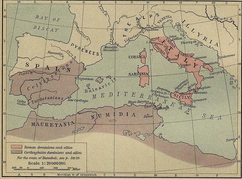
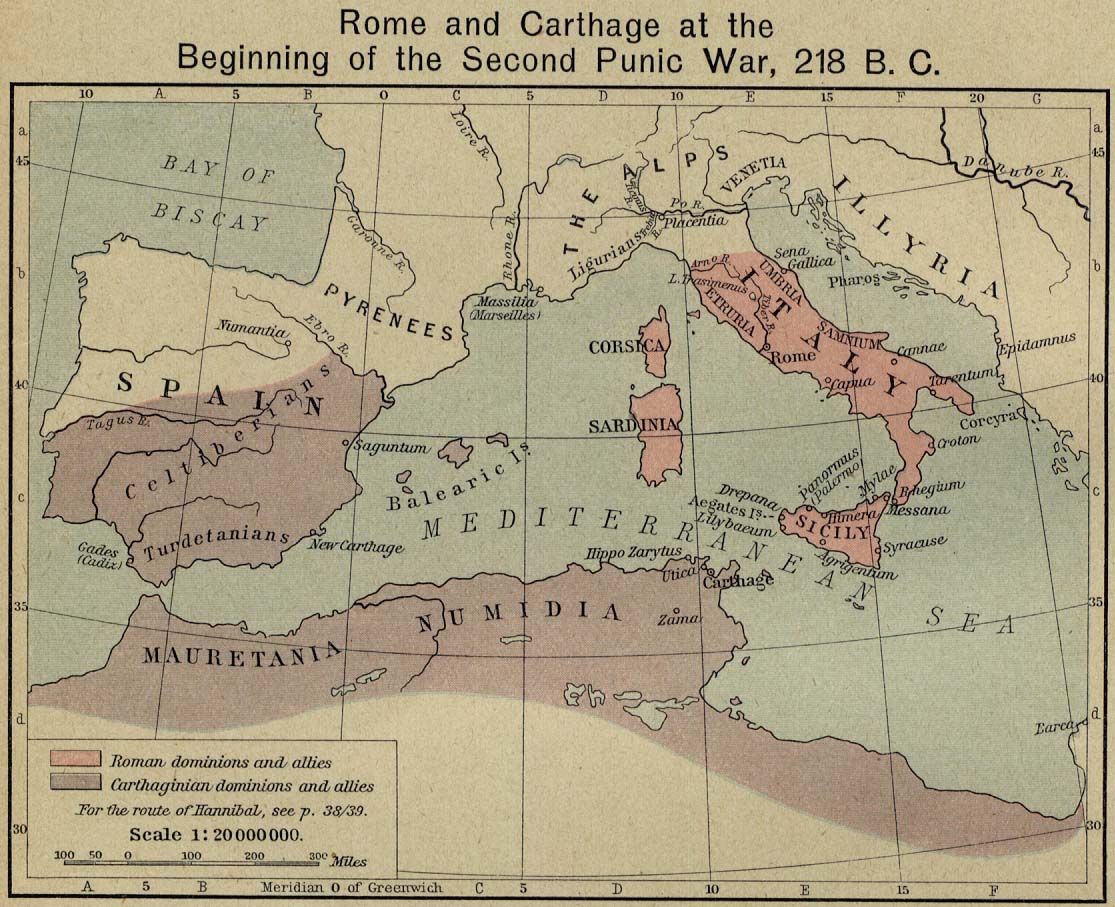
English: Rome and Carthage at the Beginning of the Second Punic War, 218 B.C. |
||||||||||||||||||||||
| উৎস |
|
||||||||||||||||||||||
| লেখক |
|
||||||||||||||||||||||
| অনুমতি (এ ফাইলের পুনঃব্যবহার) |
FAQ:
|
||||||||||||||||||||||
| অন্যান্য সংস্করণ | Shepherd-c-032.jpg: Non-cropped image from the 1911 edition of the Historical Atlas | ||||||||||||||||||||||
লাইসেন্স প্রদান
This media file is in the public domain in the United States. This applies to U.S. works where the copyright has expired, often because its first publication occurred prior to January 1, 1929, and if not then due to lack of notice or renewal. See this page for further explanation.
|
 | |
 |
This image might not be in the public domain outside of the United States; this especially applies in the countries and areas that do not apply the rule of the shorter term for US works, such as Canada, Mainland China (not Hong Kong or Macao), Germany, Mexico, and Switzerland. The creator and year of publication are essential information and must be provided. See Wikipedia:Public domain and Wikipedia:Copyrights for more details.
|
derivative works
এই ফাইলের উপজাত কর্মসমূহ:
- Map of Rome and Carthage at the start of the First Punic War.svg
- Map of Rome and Carthage at the start of the Second Punic War.svg
- Rome carthage 218-ar.png
|
|
File:Map of Rome and Carthage at the start of the Second Punic War.svg এই ফাইলের একটি ভেক্টর সংস্করণ। যখন উচ্চতর তখন এটি এই রাস্টার চিত্রের জায়গায় ব্যবহার করা উচিত।
File:Rome carthage 218.jpg → File:Map of Rome and Carthage at the start of the Second Punic War.svg
ভেক্টর গ্রাফিক্স সম্পর্কে আরও তথ্যের জন্য, কমন্স এসভিজিতে রূপান্তর সম্পর্কে পড়ুন। সেখানে মিডিয়াউইকির এসভিজি চিত্র সমর্থন সম্পর্কে তথ্য রয়েছে। |
|
ফাইলের ইতিহাস
যেকোনো তারিখ/সময়ে ক্লিক করে দেখুন ফাইলটি তখন কী অবস্থায় ছিল।
| তারিখ/সময় | সংক্ষেপচিত্র | মাত্রা | ব্যবহারকারী | মন্তব্য | |
|---|---|---|---|---|---|
| বর্তমান | ১৫:৫১, ১৭ নভেম্বর ২০০৬ | | ১,১০৮ × ৮২২ (১৯০ কিলোবাইট) | Rune X2 | == Summary == '''Rome and Carthage at the Beginning of the Second Punic War, 218 B.C.''' Scan from "Historical Atlas" by William R. Shepherd, New York, Henry Holt and Company, 1923. Original image at the [http://www.lib.utexas.edu/maps/ Perry-Castañed |
সংযোগসমূহ
এই ফাইল ব্যবহার করে এমন কোনো পাতা নেই।
ফাইলের বৈশ্বিক ব্যবহার
নিচের অন্যান্য উইকিগুলো এই ফাইলটি ব্যবহার করে:
- en.wikipedia.org-এ ব্যবহার
- es.wikipedia.org-এ ব্যবহার
- he.wikipedia.org-এ ব্যবহার
- sr.wikipedia.org-এ ব্যবহার
- sv.wikipedia.org-এ ব্যবহার
- zh.wikipedia.org-এ ব্যবহার