
চিত্র:Rarh.jpg
Rarh.jpg (২৫০ × ২৫০ পিক্সেল, ফাইলের আকার: ৫২ কিলোবাইট, এমআইএমই ধরন: image/jpeg)
| এই ফাইলটি উইকিমিডিয়া কমন্স থেকে নেওয়া। সেখানের বর্ণনা পাতার বিস্তারিত নিম্নে দেখানো হলো। (সম্পাদনা)
|
সারাংশ
| বিবরণ |
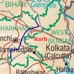
English: Map showing the region of Rarh. |
| তারিখ | |
| উৎস |
https://www.lib.utexas.edu/maps/ https://www.lib.utexas.edu/maps/middle_east_and_asia/india_physio-2001.jpg (Original file) |
| লেখক | University of Texas Libraries |
Rarh is a high, undulating continuation of the Chota Nagpur Plateau to the west, and the Ganges Delta to the east. The Bhagirathi river, a distributary of the Ganges (seen flowing just west of Kolkata in the map) forms the eastern boundary of Rarh. The northeastern extension of Jharkhand is also part of Rarh and forms the northern boundary. Odisha and the Bay of Bengal forms the southern boundary. The natural high lands at the eastern end of the Chota Nagpur Plateau (shown here approximately, as a dark blue line passing east of Ranchi) form the western boundary of Rarh.
লাইসেন্স প্রদান
| এই ফাইলটি ক্রিয়েটিভ কমন্স সিসি০ ১.০ সার্বজনীন পাবলিক ডোমেইন উৎসর্গীকরণের আওতায় রয়েছে। | |
| যেই ব্যক্তিটি এই কাজটির সাথে সংশ্লিষ্ট তিনি এই কাজটি পাবলিক ডোমেইনে মুক্ত করার মাধ্যমে তাঁর সকল স্বত্ত্ব বিশ্বের সকল কপিরাইট আইনের আওতায় ত্যাগ করেছেন। যার মধ্যে নেইবারিং অধিকার, ও আইনের মাধ্যমে এক্সটেন্টও অন্তর্গত। আপনি এই কাজটি কোন অনুমতি চাওয়া ছাড়াই মুক্তভাবে অনুলিপি, পরিবর্তন, বিতরণ করতে পারেন, এবং এমন কি কোনো বাণিজ্যিক কাজেও ব্যবহার করতে পারেন।
|
ফাইলের ইতিহাস
যেকোনো তারিখ/সময়ে ক্লিক করে দেখুন ফাইলটি তখন কী অবস্থায় ছিল।
| তারিখ/সময় | সংক্ষেপচিত্র | মাত্রা | ব্যবহারকারী | মন্তব্য | |
|---|---|---|---|---|---|
| বর্তমান | ১৬:২৫, ২১ আগস্ট ২০১৭ | | ২৫০ × ২৫০ (৫২ কিলোবাইট) | Universal Life | Better version, 250x250 and the western border is clearer. |
| ১৫:০৩, ২১ আগস্ট ২০১৭ |  | ২৭৬ × ২৬১ (৫৬ কিলোবাইট) | Universal Life | Indicated better the boundaries of Rarh. | |
| ১৪:১২, ২১ আগস্ট ২০১৭ |  | ২১৯ × ২৬১ (৩৬ কিলোবাইট) | Universal Life | Cropped the western part of Jharkhand that wasn't part of Rarh. | |
| ১৩:৫৭, ২১ আগস্ট ২০১৭ |  | ২৭৬ × ২৬১ (৪২ কিলোবাইট) | Universal Life | Zoomed better to the area that's Rarh, the previous map could be a bit confusing. | |
| ১৩:২৪, ২০ আগস্ট ২০১৭ |  | ৩৪৮ × ৩০৬ (৫৭ কিলোবাইট) | Universal Life | User created page with UploadWizard |
সংযোগসমূহ
নিচের পৃষ্ঠা(গুলো) থেকে এই ছবিতে সংযোগ আছে:
ফাইলের বৈশ্বিক ব্যবহার
নিচের অন্যান্য উইকিগুলো এই ফাইলটি ব্যবহার করে:
- ca.wikipedia.org-এ ব্যবহার
- en.wikipedia.org-এ ব্যবহার
- www.wikidata.org-এ ব্যবহার