
চিত্র:Peta soerabaja 1897.jpg

পূর্ণ রেজোলিউশন (৮৯৫ × ১,৩৬৪ পিক্সেল, ফাইলের আকার: ৩৩৫ কিলোবাইট, এমআইএমই ধরন: image/jpeg)
| এই ফাইলটি উইকিমিডিয়া কমন্স থেকে নেওয়া। সেখানের বর্ণনা পাতার বিস্তারিত নিম্নে দেখানো হলো। (সম্পাদনা)
|
সারাংশ
| বিবরণ |
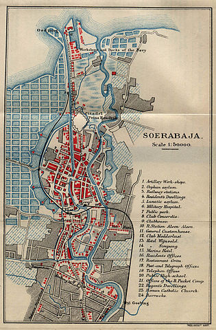
English: Map of Surabaya, Indonesia, from Guide to the Dutch East Indies by Dr. J.F. van Bemmelen and G.B. Hoover, Luzac & Co, London 1897. Lower right corner: Tresling & Co., Amsterdam. |
| তারিখ | |
| উৎস | Courtesy of the Perry-Castañeda Library Map Collection, University of Texas at Austin. [1] |
| লেখক |
লাইসেন্স প্রদান
|
এই কর্মটি এর উৎস দেশে পাবলিক ডোমেইনে রয়েছে এবং অন্যান্য দেশ ও অঞ্চলে যেখানে কপিরাটের সময়সীমা হচ্ছে লেখকের জীবন যোগ ৭০ বছর বা তাঁর কম।
| |
| এই ফাইলটি কপিরাইট আইনের আওতায় জানা সকল বাধানিষেধ মুক্ত বলে চিহ্নিত হয়েছে, যার মধ্যে সম্পর্কিত সকল স্বত্ব ও নেইবারিং সত্ত্ব সংযুক্ত। | |
ফাইলের ইতিহাস
যেকোনো তারিখ/সময়ে ক্লিক করে দেখুন ফাইলটি তখন কী অবস্থায় ছিল।
| তারিখ/সময় | সংক্ষেপচিত্র | মাত্রা | ব্যবহারকারী | মন্তব্য | |
|---|---|---|---|---|---|
| বর্তমান | ০০:৫৫, ৯ ডিসেম্বর ২০০৫ | | ৮৯৫ × ১,৩৬৪ (৩৩৫ কিলোবাইট) | Cdc~commonswiki | Map of Surabaya, Indonesia, from ''Guide to the Dutch East Indies'' by Dr. J.F. van Bemmelen and G.B. Hoover, Luzac & Co, London 1897. Courtesy of the Perry-Castañeda Library Map Collection, University of Texas at Austin. [http://www.lib.utexas.edu/maps/ |
সংযোগসমূহ
নিচের পৃষ্ঠা(গুলো) থেকে এই ছবিতে সংযোগ আছে:
ফাইলের বৈশ্বিক ব্যবহার
নিচের অন্যান্য উইকিগুলো এই ফাইলটি ব্যবহার করে:
- ace.wikipedia.org-এ ব্যবহার
- ast.wikipedia.org-এ ব্যবহার
- ba.wikipedia.org-এ ব্যবহার
- bxr.wikipedia.org-এ ব্যবহার
- de.wikipedia.org-এ ব্যবহার
- es.wikipedia.org-এ ব্যবহার
- fr.wikipedia.org-এ ব্যবহার
- gl.wikipedia.org-এ ব্যবহার
- id.wikipedia.org-এ ব্যবহার
- it.wikipedia.org-এ ব্যবহার
- ml.wikipedia.org-এ ব্যবহার
- nl.wikipedia.org-এ ব্যবহার
- pt.wikipedia.org-এ ব্যবহার
- ru.wikipedia.org-এ ব্যবহার
- zh-yue.wikipedia.org-এ ব্যবহার