
চিত্র:Pacific Ocean.png
এর চেয়ে বেশি রেজোলিউশন লভ্য নয়।
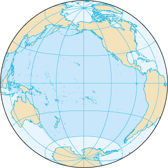
Pacific_Ocean.png (৩৩০ × ৩৩০ পিক্সেল, ফাইলের আকার: ২৮ কিলোবাইট, এমআইএমই ধরন: image/png)
| এই ফাইলটি উইকিমিডিয়া কমন্স থেকে নেওয়া। সেখানের বর্ণনা পাতার বিস্তারিত নিম্নে দেখানো হলো। (সম্পাদনা)
|
সারাংশ
| বিবরণ |
English: Pacific Ocean map, tagged in English |
| তারিখ | |
| উৎস | CIA World Factbook |
| লেখক | CIA World Factbook |
| অন্যান্য সংস্করণ |
এই ফাইলের উপজাত কর্মসমূহ: |
.png)

|
This locator map image could be re-created using vector graphics as an SVG file. This has several advantages; see Commons:Media for cleanup for more information. If an SVG form of this image is available, please upload it and afterwards replace this template with
{{vector version available|new image name}}.
It is recommended to name the SVG file “Pacific Ocean.svg”—then the template Vector version available (or Vva) does not need the new image name parameter. |
লাইসেন্স প্রদান
এই ছবিটি পাবলিক ডোমেইনে কারণ এটিতে উপকরণ রয়েছে যা মূলত মার্কিন যুক্তরাষ্ট্রের কেন্দ্রীয় গোয়েন্দা সংস্থার ওয়ার্ল্ড ফ্যাক্টবুক থেকে এসেছে।
|
 |
মূল আপলোড লগ
মূল বিবরণ পাতাটি এখানে ছিল। নিম্নলিখিত সকল ব্যবহারকারীর নাম en.wikipedia-এ উল্লেখ করা ছিল।
This file was originaly uploaded to en.wikipedia as File:Pacificocean.PNG, if you have access to the deleted history, you could to complete this field.
ফাইলের ইতিহাস
যেকোনো তারিখ/সময়ে ক্লিক করে দেখুন ফাইলটি তখন কী অবস্থায় ছিল।
| তারিখ/সময় | সংক্ষেপচিত্র | মাত্রা | ব্যবহারকারী | মন্তব্য | |
|---|---|---|---|---|---|
| বর্তমান | ১৯:৩৩, ২৭ আগস্ট ২০১৯ | | ৩৩০ × ৩৩০ (২৮ কিলোবাইট) | Kaldari | removing black triagle |
| ১৯:১৬, ২৭ আগস্ট ২০১৯ |  | ৩৩০ × ৩৩০ (১৪ কিলোবাইট) | Kaldari | Reverting sloppy background removal leaving jagged edges, and also to be consistent with other ocean maps | |
| ১০:১১, ৩০ জুলাই ২০১৯ |  | ৩৩০ × ৩৩০ (১৩ কিলোবাইট) | Aplaice | Reduce file size back to previous levels (from 2009) while keeping transparent background (as in 2017). | |
| ১৫:৪৭, ২১ জুন ২০১৭ |  | ৩৩০ × ৩৩০ (৯৮ কিলোবাইট) | Wiki test 0001 | Underground the change Surrounding background. | |
| ২০:১৬, ২২ আগস্ট ২০০৯ |  | ৩৩০ × ৩৩০ (১৪ কিলোবাইট) | Serg!o | language neutral map | |
| ২২:৫২, ৪ ডিসেম্বর ২০০৪ |  | ৩৩০ × ৩৩০ (১৭ কিলোবাইট) | Alfio | Pacific Ocean map |
সংযোগসমূহ
এই ফাইল ব্যবহার করে এমন কোনো পাতা নেই।
ফাইলের বৈশ্বিক ব্যবহার
নিচের অন্যান্য উইকিগুলো এই ফাইলটি ব্যবহার করে:
- ab.wikipedia.org-এ ব্যবহার
- af.wikipedia.org-এ ব্যবহার
- arc.wikipedia.org-এ ব্যবহার
- ar.wikipedia.org-এ ব্যবহার
- arz.wikipedia.org-এ ব্যবহার
- ast.wikipedia.org-এ ব্যবহার
- as.wikipedia.org-এ ব্যবহার
- av.wikipedia.org-এ ব্যবহার
- az.wikipedia.org-এ ব্যবহার
- az.wiktionary.org-এ ব্যবহার
- ba.wikipedia.org-এ ব্যবহার
- bcl.wikipedia.org-এ ব্যবহার
- be-tarask.wikipedia.org-এ ব্যবহার
- be.wikipedia.org-এ ব্যবহার
- Рапануі (востраў)
- Ціхі акіян
- Спіс аб’ектаў Сусветнай спадчыны ЮНЕСКА ў Аўстраліі
- Вялікі бар’ерны рыф
- Сіднейскі оперны тэатр
- Востраў Херд і астравы Мак-Доналд
- Лорд-Хау
- Болс-Пірамід
- Нацыянальны парк Какаду
- Дажджавыя лясы ўсходняга ўзбярэжжа Аўстраліі
- Фрэйзер (востраў)
- Шаблон:Сусветная спадчына ў Акіяніі
- Галапагас
- Уіландра
- Спіс аб’ектаў Сусветнай спадчыны ЮНЕСКА ў Папуа — Новай Гвінеі
- Спіс аб’ектаў Сусветнай спадчыны ЮНЕСКА ў Вануату
- Хендэрсан (востраў)
- Макуоры
- Фенікс (астравы)
- Какос (востраў)
- Бікіні (атол)
- Старажытнае земляробчае паселішча Кук
এই ফাইলের অন্যান্য বৈশ্বিক ব্যবহার দেখুন।