
চিত্র:Northern Mariana Islands map.gif
এর চেয়ে বেশি রেজোলিউশন লভ্য নয়।
Northern_Mariana_Islands_map.gif (৩৪৫ × ৩৭১ পিক্সেল, ফাইলের আকার: ২৪ কিলোবাইট, এমআইএমই ধরন: image/gif)
| এই ফাইলটি উইকিমিডিয়া কমন্স থেকে নেওয়া। সেখানের বর্ণনা পাতার বিস্তারিত নিম্নে দেখানো হলো। (সম্পাদনা)
|
সারাংশ
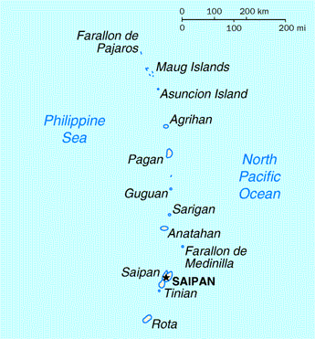
| বিবরণ | Map of the Northern Mariana Islands |
| উৎস | http://www.doi.gov/oia/Islandpages/cnmipage.htm |
| লেখক | United States Department of the Interior |
লাইসেন্স প্রদান
| This image or media file contains material based on a work of a United States Department of the Interior employee, created as part of that person's official duties. As a work of the U.S. federal government, such work is in the public domain in the United States. See the Department of the Interior copyright policy for more information. |  |
ফাইলের ইতিহাস
যেকোনো তারিখ/সময়ে ক্লিক করে দেখুন ফাইলটি তখন কী অবস্থায় ছিল।
| তারিখ/সময় | সংক্ষেপচিত্র | মাত্রা | ব্যবহারকারী | মন্তব্য | |
|---|---|---|---|---|---|
| বর্তমান | ০৩:১৭, ১৮ আগস্ট ২০১০ | | ৩৪৫ × ৩৭১ (২৪ কিলোবাইট) | Ras67 | cropped |
| ০০:২৪, ১৭ মে ২০০৮ |  | ৩৫১ × ৩৭৭ (২৫ কিলোবাইট) | Scanlan | {{Information |Description=Map of the Northern Mariana Islands |Source=http://www.doi.gov/oia/Islandpages/cnmipage.htm |Date= |Author=United States Department of the Interior |Permission= |other_versions= }} [[Category:Maps of the Northern Marian |
সংযোগসমূহ
নিচের পৃষ্ঠা(গুলো) থেকে এই ছবিতে সংযোগ আছে:
ফাইলের বৈশ্বিক ব্যবহার
নিচের অন্যান্য উইকিগুলো এই ফাইলটি ব্যবহার করে:
- af.wikipedia.org-এ ব্যবহার
- ar.wikipedia.org-এ ব্যবহার
- ast.wikipedia.org-এ ব্যবহার
- be-tarask.wikipedia.org-এ ব্যবহার
- ch.wikipedia.org-এ ব্যবহার
- cs.wikipedia.org-এ ব্যবহার
- cy.wikipedia.org-এ ব্যবহার
- da.wikipedia.org-এ ব্যবহার
- en.wikipedia.org-এ ব্যবহার
- es.wikipedia.org-এ ব্যবহার
- fa.wikipedia.org-এ ব্যবহার
- fr.wikipedia.org-এ ব্যবহার
- he.wikipedia.org-এ ব্যবহার
- id.wikipedia.org-এ ব্যবহার
- incubator.wikimedia.org-এ ব্যবহার
- io.wikipedia.org-এ ব্যবহার
- ja.wikipedia.org-এ ব্যবহার
- ka.wikipedia.org-এ ব্যবহার
- ml.wikipedia.org-এ ব্যবহার
- mr.wikipedia.org-এ ব্যবহার
- pt.wikipedia.org-এ ব্যবহার
- ru.wikipedia.org-এ ব্যবহার
- ta.wikipedia.org-এ ব্যবহার
- to.wikipedia.org-এ ব্যবহার
- tr.wiktionary.org-এ ব্যবহার
- tt.wikipedia.org-এ ব্যবহার
- uk.wikipedia.org-এ ব্যবহার