
চিত্র:Malay language Spoken Area Map v1.png
এর চেয়ে বেশি রেজোলিউশন লভ্য নয়।
Malay_language_Spoken_Area_Map_v1.png (৩৩৩ × ১৫৪ পিক্সেল, ফাইলের আকার: ৪ কিলোবাইট, এমআইএমই ধরন: image/png)
| এই ফাইলটি উইকিমিডিয়া কমন্স থেকে নেওয়া। সেখানের বর্ণনা পাতার বিস্তারিত নিম্নে দেখানো হলো। (সম্পাদনা)
|
সারাংশ

|
This linguistic map image could be re-created using vector graphics as an SVG file. This has several advantages; see Commons:Media for cleanup for more information. If an SVG form of this image is available, please upload it and afterwards replace this template with
{{vector version available|new image name}}.
It is recommended to name the SVG file “Malay language Spoken Area Map v1.svg”—then the template Vector version available (or Vva) does not need the new image name parameter. |
| বিবরণ |
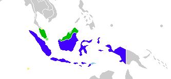
English: This is crop and edit of a .png export of the image at File:BlankMap-World6.svg. The original author released that image into the public domain for any use. This version is released under the CC-Zero license. |
| তারিখ | ১৩ ফেব্রুয়ারি ২০১১ (মূল আপলোডের তারিখ) |
| উৎস | en.wikipedia থেকে কমন্সে স্থানান্তরিত করা হয়েছে Zscout370 কর্তৃক CommonsHelper ব্যবহার করে। |
| লেখক | ইংরেজি উইকিপিডিয়া-এর True |
লাইসেন্স প্রদান
ইংরেজি উইকিপিডিয়া-এর True, এই কাজের স্বত্বাধিকারী, এতদ্দ্বারা এই কাজকে নিম্ন বর্ণিত লাইসেন্সের আওতায় প্রকাশিত করেছেন:
| এই ফাইলটি ক্রিয়েটিভ কমন্স সিসি০ ১.০ সার্বজনীন পাবলিক ডোমেইন উৎসর্গীকরণের আওতায় রয়েছে। | |
| যেই ব্যক্তিটি এই কাজটির সাথে সংশ্লিষ্ট তিনি এই কাজটি পাবলিক ডোমেইনে মুক্ত করার মাধ্যমে তাঁর সকল স্বত্ত্ব বিশ্বের সকল কপিরাইট আইনের আওতায় ত্যাগ করেছেন। যার মধ্যে নেইবারিং অধিকার, ও আইনের মাধ্যমে এক্সটেন্টও অন্তর্গত। আপনি এই কাজটি কোন অনুমতি চাওয়া ছাড়াই মুক্তভাবে অনুলিপি, পরিবর্তন, বিতরণ করতে পারেন, এবং এমন কি কোনো বাণিজ্যিক কাজেও ব্যবহার করতে পারেন।
|
মূল আপলোড লগ
মূল বিবরণ পাতাটি এখানে ছিল। নিম্নলিখিত সকল ব্যবহারকারীর নাম en.wikipedia-এ উল্লেখ করা ছিল।
- 2012-02-20 03:34 Kwamikagami 333×154× (4555 bytes) correct area in Thailand, add Cocos Isl.
- 2012-02-20 03:17 Kwamikagami 333×154× (4570 bytes) Reverted to version as of 23:23, 13 February 2011
- 2011-09-14 23:58 Niduzzi 736×386× (33038 bytes)
- 2011-02-13 23:23 True 333×154× (4570 bytes) This is crop and edit of a .png export of the image at http://en.wikipedia.org/wiki/File:BlankMap-World6.svg. The original author released that image into the public domain for any use. This version is released under the CC-Zero license.
ফাইলের ইতিহাস
যেকোনো তারিখ/সময়ে ক্লিক করে দেখুন ফাইলটি তখন কী অবস্থায় ছিল।
| তারিখ/সময় | সংক্ষেপচিত্র | মাত্রা | ব্যবহারকারী | মন্তব্য | |
|---|---|---|---|---|---|
| বর্তমান | ০৮:২৩, ২৫ ফেব্রুয়ারি ২০২২ | | ৩৩৩ × ১৫৪ (৪ কিলোবাইট) | Kwamikagami | no longer a map of where Malay is spoken |
| ০৫:৫২, ২৬ অক্টোবর ২০১৮ |  | ৪,৩৮৭ × ১,৯২২ (৩৩৬ কিলোবাইট) | Bennylin | Edit some colors | |
| ০৫:৪০, ২৬ অক্টোবর ২০১৮ |  | ৪,৩০০ × ১,৯১৮ (৫৩৫ কিলোবাইট) | Bennylin | Change ugly map with PNG version of File:Maritime South East Asia.svg | |
| ০৪:৫১, ২১ জুন ২০১২ |  | ৩৩৩ × ১৫৪ (৪ কিলোবাইট) | File Upload Bot (Magnus Manske) | Transfered from en.wikipedia by User:zscout370 using CommonsHelper |
সংযোগসমূহ
এই ফাইল ব্যবহার করে এমন কোনো পাতা নেই।
ফাইলের বৈশ্বিক ব্যবহার
নিচের অন্যান্য উইকিগুলো এই ফাইলটি ব্যবহার করে:
- ckb.wikipedia.org-এ ব্যবহার
- el.wikipedia.org-এ ব্যবহার
- en.wikipedia.org-এ ব্যবহার
- es.wikipedia.org-এ ব্যবহার
- fa.wikipedia.org-এ ব্যবহার
- frr.wikipedia.org-এ ব্যবহার
- id.wikipedia.org-এ ব্যবহার
- incubator.wikimedia.org-এ ব্যবহার
- mi.wikipedia.org-এ ব্যবহার
- nl.wikipedia.org-এ ব্যবহার
- zh.wikipedia.org-এ ব্যবহার