
চিত্র:Karte Pomponius Mela.jpg

পূর্ণ রেজোলিউশন (১২,৪৪৯ × ১৭,০৫৫ পিক্সেল, ফাইলের আকার: ৫২.৮৪ মেগাবাইট, এমআইএমই ধরন: image/jpeg)
| এই ফাইলটি উইকিমিডিয়া কমন্স থেকে নেওয়া। সেখানের বর্ণনা পাতার বিস্তারিত নিম্নে দেখানো হলো। (সম্পাদনা)
|
সারাংশ
| সতর্কীকরণ | মূল ফাইলে বড় সংখ্যার পিক্সেল আছে এবং এটি সঠিকভাবে লোড নাও হতে পারে বা আপনার ব্রাউজার নিশ্চল করে দিতে। |
|---|
| বিবরণ |
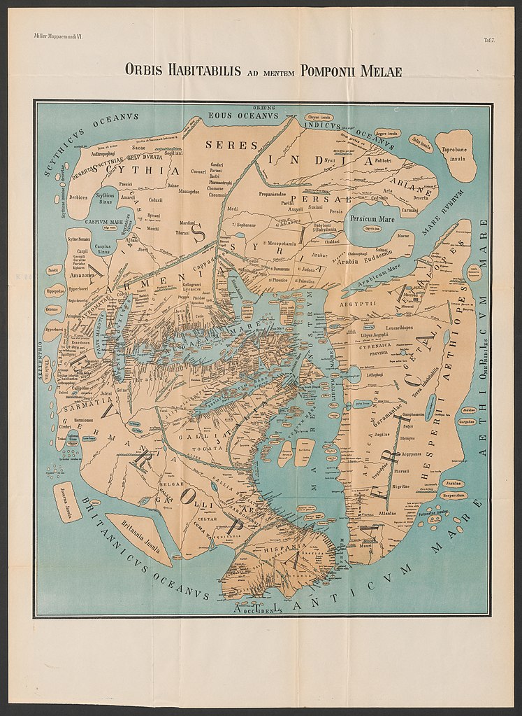
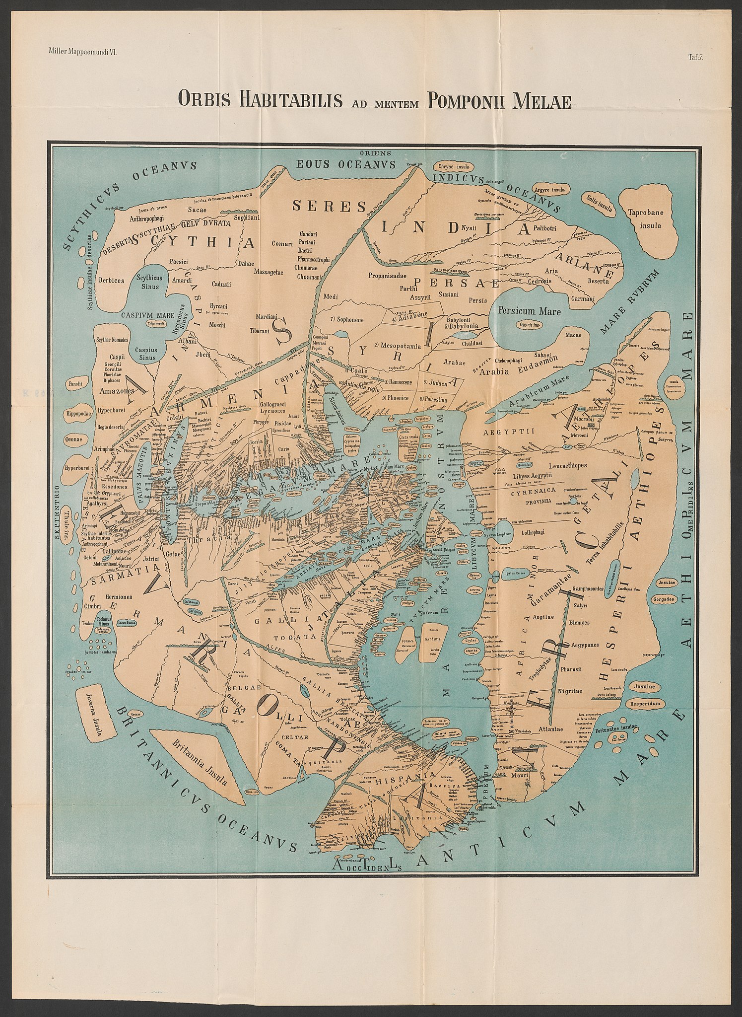
Deutsch: Weltkarte des Pomponius Mela in der Rekonstruktion von K. Miller (1898) English: World Map of Pomponius Mela as reconstructed by K. Miller (1898). |
| তারিখ | |
| উৎস | "Orbis habitabilis ad mentem Pomponii Melae", Mappaemundi, Heft VI. "Rekonstruierte Karten", Tafel 7. |
| লেখক | Konrad Miller |
| অন্যান্য সংস্করণ |
 |
.jpg)
লাইসেন্স প্রদান
|
এই কর্মটি এর উৎস দেশে পাবলিক ডোমেইনে রয়েছে এবং অন্যান্য দেশ ও অঞ্চলে যেখানে কপিরাটের সময়সীমা হচ্ছে লেখকের জীবন যোগ ৭০ বছর বা তাঁর কম।
| |
| এই ফাইলটি কপিরাইট আইনের আওতায় জানা সকল বাধানিষেধ মুক্ত বলে চিহ্নিত হয়েছে, যার মধ্যে সম্পর্কিত সকল স্বত্ব ও নেইবারিং সত্ত্ব সংযুক্ত। | |
ফাইলের ইতিহাস
যেকোনো তারিখ/সময়ে ক্লিক করে দেখুন ফাইলটি তখন কী অবস্থায় ছিল।
| তারিখ/সময় | সংক্ষেপচিত্র | মাত্রা | ব্যবহারকারী | মন্তব্য | |
|---|---|---|---|---|---|
| বর্তমান | ১২:০০, ২ জুলাই ২০২০ | | ১২,৪৪৯ × ১৭,০৫৫ (৫২.৮৪ মেগাবাইট) | Sette-quattro | Higher quality from https://www.e-rara.ch/zut/content/zoom/11583686 |
| ১৩:১৮, ২৬ ফেব্রুয়ারি ২০১৫ |  | ২,৪৪৮ × ৩,২৬৪ (২.৯১ মেগাবাইট) | Dbachmann | Reverted to version as of 19:54, 13 May 2008 | |
| ০৬:৫৯, ১৯ ফেব্রুয়ারি ২০১৫ |  | ২,৩২৮ × ২,৬৫০ (১.৭৩ মেগাবাইট) | مانفی | color improved | |
| ০৪:৫৪, ১৮ ডিসেম্বর ২০১০ |  | ২,৩২৮ × ২,৬৫০ (১.৯৭ মেগাবাইট) | Uploadalt | formatted | |
| ১৯:৫৪, ১৩ মে ২০০৮ |  | ২,৪৪৮ × ৩,২৬৪ (২.৯১ মেগাবাইট) | Fingalo | == Beschreibung == {{Information |Description=Weltkarte des Pomponius Mela |Source=Mappae Mundi Bd. Vi. "Rekonstruierte Karten" |Date=1898 |Author=Dr. Konrad Miller |Permission= |other_versions= }} Category:Fingalo Category:Old maps == [[Commons:C |
সংযোগসমূহ
ফাইলের বৈশ্বিক ব্যবহার
নিচের অন্যান্য উইকিগুলো এই ফাইলটি ব্যবহার করে:
- als.wikipedia.org-এ ব্যবহার
- ar.wikipedia.org-এ ব্যবহার
- arz.wikipedia.org-এ ব্যবহার
- ast.wikipedia.org-এ ব্যবহার
- ba.wikipedia.org-এ ব্যবহার
- bg.wikipedia.org-এ ব্যবহার
- br.wikipedia.org-এ ব্যবহার
- ca.wikipedia.org-এ ব্যবহার
- da.wikipedia.org-এ ব্যবহার
- de.wikipedia.org-এ ব্যবহার
- el.wikipedia.org-এ ব্যবহার
- en.wikipedia.org-এ ব্যবহার
- eo.wikipedia.org-এ ব্যবহার
- es.wikipedia.org-এ ব্যবহার
- et.wikipedia.org-এ ব্যবহার
- eu.wikipedia.org-এ ব্যবহার
- fa.wikipedia.org-এ ব্যবহার
- fa.wikibooks.org-এ ব্যবহার
- fi.wikipedia.org-এ ব্যবহার
- fi.wikibooks.org-এ ব্যবহার
- fr.wikipedia.org-এ ব্যবহার
- fr.wiktionary.org-এ ব্যবহার
- gl.wikipedia.org-এ ব্যবহার
- he.wikipedia.org-এ ব্যবহার
- id.wikipedia.org-এ ব্যবহার
- it.wikipedia.org-এ ব্যবহার
এই ফাইলের অন্যান্য বৈশ্বিক ব্যবহার দেখুন।