
চিত্র:Japan kyushu map small.png
এর চেয়ে বেশি রেজোলিউশন লভ্য নয়।
Japan_kyushu_map_small.png (২৩৫ × ৩০০ পিক্সেল, ফাইলের আকার: ৬ কিলোবাইট, এমআইএমই ধরন: image/png)
| এই ফাইলটি উইকিমিডিয়া কমন্স থেকে নেওয়া। সেখানের বর্ণনা পাতার বিস্তারিত নিম্নে দেখানো হলো। (সম্পাদনা)
|

|
This map image could be re-created using vector graphics as an SVG file. This has several advantages; see Commons:Media for cleanup for more information. If an SVG form of this image is available, please upload it and afterwards replace this template with
{{vector version available|new image name}}.
It is recommended to name the SVG file “Japan kyushu map small.svg”—then the template Vector version available (or Vva) does not need the new image name parameter. |
- What:
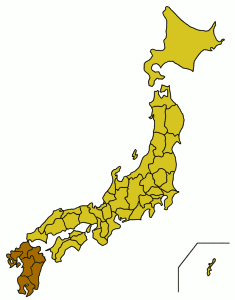
- English: A location map showing the location of Kyushu in relation to Japan.
- Latina: Charta geographica locum Ximi inter Iaponiam et eius provincias monstrans.
- Whence: From the English Wikipedia (Image:Japan kyushu map small.png), first uploaded by User:Synthetik.
Small map of Kyushu region
Map outline from public domain maps at http://aoki2.si.gunma-u.ac.jp/map/map.html

|
Shigenobu AOKI, the copyright holder of this work, allows anyone to use it for any purpose including unrestricted redistribution, commercial use, and modification.
|
ফাইলের ইতিহাস
যেকোনো তারিখ/সময়ে ক্লিক করে দেখুন ফাইলটি তখন কী অবস্থায় ছিল।
| তারিখ/সময় | সংক্ষেপচিত্র | মাত্রা | ব্যবহারকারী | মন্তব্য | |
|---|---|---|---|---|---|
| বর্তমান | ০৩:৪৫, ৫ ফেব্রুয়ারি ২০০৫ | | ২৩৫ × ৩০০ (৬ কিলোবাইট) | Muke | From the English Wikipedia, {{PD}} |
সংযোগসমূহ
নিচের পৃষ্ঠা(গুলো) থেকে এই ছবিতে সংযোগ আছে:
ফাইলের বৈশ্বিক ব্যবহার
নিচের অন্যান্য উইকিগুলো এই ফাইলটি ব্যবহার করে:
- af.wikipedia.org-এ ব্যবহার
- ar.wikipedia.org-এ ব্যবহার
- az.wikipedia.org-এ ব্যবহার
- ba.wikipedia.org-এ ব্যবহার
- be.wikipedia.org-এ ব্যবহার
- bg.wikipedia.org-এ ব্যবহার
- br.wikipedia.org-এ ব্যবহার
- ckb.wikipedia.org-এ ব্যবহার
- cs.wikipedia.org-এ ব্যবহার
- cy.wikipedia.org-এ ব্যবহার
- da.wikipedia.org-এ ব্যবহার
- de.wikipedia.org-এ ব্যবহার
- el.wikipedia.org-এ ব্যবহার
- en.wikinews.org-এ ব্যবহার
- es.wikipedia.org-এ ব্যবহার
- et.wikipedia.org-এ ব্যবহার
- fa.wikipedia.org-এ ব্যবহার
- fi.wiktionary.org-এ ব্যবহার
- fo.wikipedia.org-এ ব্যবহার
- frr.wikipedia.org-এ ব্যবহার
- fr.wikinews.org-এ ব্যবহার
- fr.wikivoyage.org-এ ব্যবহার
- fr.wiktionary.org-এ ব্যবহার
- gd.wikipedia.org-এ ব্যবহার
- gl.wikipedia.org-এ ব্যবহার
- hak.wikipedia.org-এ ব্যবহার
- ha.wikipedia.org-এ ব্যবহার
- he.wikipedia.org-এ ব্যবহার
- hi.wikipedia.org-এ ব্যবহার
- hr.wikipedia.org-এ ব্যবহার
- hu.wikipedia.org-এ ব্যবহার
- ilo.wikipedia.org-এ ব্যবহার
- is.wikipedia.org-এ ব্যবহার
- it.wikipedia.org-এ ব্যবহার
- it.wikivoyage.org-এ ব্যবহার
- ka.wikipedia.org-এ ব্যবহার
- kk.wikipedia.org-এ ব্যবহার
- la.wiktionary.org-এ ব্যবহার
- mk.wikipedia.org-এ ব্যবহার
- mr.wikipedia.org-এ ব্যবহার
- nn.wikipedia.org-এ ব্যবহার
এই ফাইলের অন্যান্য বৈশ্বিক ব্যবহার দেখুন।