
চিত্র:Islam in Netherlands.jpg
এই প্রাকদর্শনের আকার: ৫১৫ × ৫৯৯ পিক্সেল। অন্যান্য আকারসমূহ: ২০৬ × ২৪০ পিক্সেল | ৪১২ × ৪৮০ পিক্সেল | ৬৬০ × ৭৬৮ পিক্সেল | ১,০২৭ × ১,১৯৫ পিক্সেল।
পূর্ণ রেজোলিউশন (১,০২৭ × ১,১৯৫ পিক্সেল, ফাইলের আকার: ২৬৪ কিলোবাইট, এমআইএমই ধরন: image/jpeg)
| এই ফাইলটি উইকিমিডিয়া কমন্স থেকে নেওয়া। সেখানের বর্ণনা পাতার বিস্তারিত নিম্নে দেখানো হলো। (সম্পাদনা)
|
| বিবরণ |
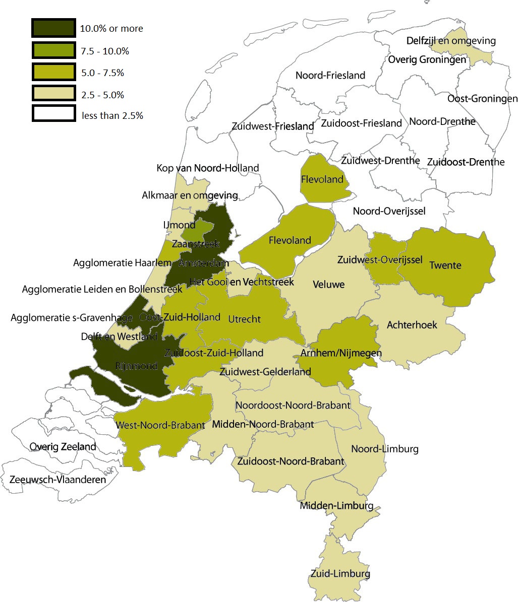
English: Share of Muslims per COROP area, 1 January 2004 . Data are from Statistics Netherlands (this Statline table); note that Statistics Netherlands calculated the number of muslims by adding up all persons by country of 'origin'. That method changed in 2006, allowing for a more accurate measuring of actual muslims; see this CBS webpage. |
| তারিখ | (UTC) |
| উৎস | |
| লেখক |
|
| এটি একটি পুনঃসম্পাদিত চিত্র, যার মানে হল যে এটি ডিজিটালরূপে এটির মূল সংস্করণ থেকে পরিবর্তন করা হয়েছে। পরিবর্তন: Share of Muslims per COROP area, 1 January 2004। আসলটি দেখা যাবে এখানে: Coropgebieden plain.png। Giornorosso কর্তৃক এটি পরিবর্তিত হয়েছে।
|
আমি, এই কাজের স্বত্বাধিকারী, এতদ্দ্বারা আমি এই কাজকে নিম্ন বর্ণিত লাইসেন্সের আওতায় প্রকাশ করলাম:
| এই ফাইলটি ক্রিয়েটিভ কমন্স সিসি০ ১.০ সার্বজনীন পাবলিক ডোমেইন উৎসর্গীকরণের আওতায় রয়েছে। | |
| যেই ব্যক্তিটি এই কাজটির সাথে সংশ্লিষ্ট তিনি এই কাজটি পাবলিক ডোমেইনে মুক্ত করার মাধ্যমে তাঁর সকল স্বত্ত্ব বিশ্বের সকল কপিরাইট আইনের আওতায় ত্যাগ করেছেন। যার মধ্যে নেইবারিং অধিকার, ও আইনের মাধ্যমে এক্সটেন্টও অন্তর্গত। আপনি এই কাজটি কোন অনুমতি চাওয়া ছাড়াই মুক্তভাবে অনুলিপি, পরিবর্তন, বিতরণ করতে পারেন, এবং এমন কি কোনো বাণিজ্যিক কাজেও ব্যবহার করতে পারেন।
|
মূল আপলোড লগ
This image is a derivative work of the following images:
- File:Coropgebieden_plain.png licensed with Cc-zero
- 2010-07-28T16:31:25Z Classical geographer 1027x1195 (213857 Bytes) Without border.
- 2010-07-28T16:30:11Z Classical geographer 1102x1300 (215966 Bytes) B&W and with more readable labels.
- 2009-07-09T11:31:36Z Classical geographer 1199x1407 (554327 Bytes) [[Category:Maps of the Netherlands]] [[Category:Statistical divisions]]
- 2009-07-09T11:30:29Z Classical geographer 3588x3529 (566115 Bytes) {{Information |Description={{en|1=Map of the Dutch NUTS3 regions (COROP regions). Made using GIS software.}} |Source=Own work by uploader |Author=[[User:Classical geographer|Classical geographer]] |Date=2009-07-09 |Permission
Uploaded with derivativeFX
ফাইলের ইতিহাস
যেকোনো তারিখ/সময়ে ক্লিক করে দেখুন ফাইলটি তখন কী অবস্থায় ছিল।
| তারিখ/সময় | সংক্ষেপচিত্র | মাত্রা | ব্যবহারকারী | মন্তব্য | |
|---|---|---|---|---|---|
| বর্তমান | ০৫:০৫, ৬ জানুয়ারি ২০১১ | | ১,০২৭ × ১,১৯৫ (২৬৪ কিলোবাইট) | Giornorosso | {{Information |Description={{en|1=Map of the Dutch NUTS3 regions (COROP regions). Made using GIS software.}} |Source=*File:Coropgebieden_plain.png |Date=2011-01-06 05:02 (UTC) |Author=*File:Coropgebieden_plain.png: [[User:Classical geographer| |
সংযোগসমূহ
নিচের পৃষ্ঠা(গুলো) থেকে এই ছবিতে সংযোগ আছে:
ফাইলের বৈশ্বিক ব্যবহার
নিচের অন্যান্য উইকিগুলো এই ফাইলটি ব্যবহার করে:
- ar.wikipedia.org-এ ব্যবহার
- fr.wikipedia.org-এ ব্যবহার
- tt.wikipedia.org-এ ব্যবহার