
চিত্র:Iceland Mid-Atlantic Ridge map.svg

এই SVG ফাইলের জন্য এই PNG প্রাকদর্শনের আকার: ৩৭৬ × ৩৯০ পিক্সেল। অন্যান্য আকারসমূহ: ২৩১ × ২৪০ পিক্সেল | ৪৬৩ × ৪৮০ পিক্সেল | ৭৪০ × ৭৬৮ পিক্সেল | ৯৮৭ × ১,০২৪ পিক্সেল | ১,৯৭৪ × ২,০৪৮ পিক্সেল।
পূর্ণ রেজোলিউশন (এসভিজি ফাইল, সাধারণত ৩৭৬ × ৩৯০ পিক্সেল, ফাইলের আকার: ১২৯ কিলোবাইট)
| এই ফাইলটি উইকিমিডিয়া কমন্স থেকে নেওয়া। সেখানের বর্ণনা পাতার বিস্তারিত নিম্নে দেখানো হলো। (সম্পাদনা)
|
সারাংশ
| বিবরণ | |
| তারিখ | |
| উৎস | http://pubs.usgs.gov/gip/dynamic/understanding.html |
| লেখক | http://pubs.usgs.gov/gip/dynamic/understanding.html |
| অন্যান্য সংস্করণ |
|


লাইসেন্স প্রদান
This image is in the public domain in the United States because it only contains materials that originally came from the United States Geological Survey, an agency of the United States Department of the Interior. For more information, see the official USGS copyright policy.
|
| Annotations | This image is annotated: View the annotations at Commons |
ফাইলের ইতিহাস
যেকোনো তারিখ/সময়ে ক্লিক করে দেখুন ফাইলটি তখন কী অবস্থায় ছিল।
| তারিখ/সময় | সংক্ষেপচিত্র | মাত্রা | ব্যবহারকারী | মন্তব্য | |
|---|---|---|---|---|---|
| বর্তমান | ১৮:৪৮, ১০ জানুয়ারি ২০১৪ | | ৩৭৬ × ৩৯০ (১২৯ কিলোবাইট) | Amitchell125 | text improved |
| ১৪:৪২, ২৬ ফেব্রুয়ারি ২০১০ |  | ৩৭৬ × ৩৯০ (৬৮ কিলোবাইট) | Beao | Tweak. | |
| ১৪:৪০, ২৬ ফেব্রুয়ারি ২০১০ |  | ৩৭৬ × ৩৯০ (৬৮ কিলোবাইট) | Beao | Tweak. | |
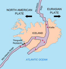
| ১৪:৩৭, ২৬ ফেব্রুয়ারি ২০১০ |  | ৩৭৬ × ৩৯০ (৬৮ কিলোবাইট) | Beao | == Summary == {{Information |Description={{en|1=Map showing the Mid-Atlantic Ridge splitting Iceland and separating the North American and Eurasian Plates. The map also shows Reykjavik, the capital of Iceland, the Thingvellir area, and the locations of so |
সংযোগসমূহ
নিচের পৃষ্ঠা(গুলো) থেকে এই ছবিতে সংযোগ আছে:
ফাইলের বৈশ্বিক ব্যবহার
নিচের অন্যান্য উইকিগুলো এই ফাইলটি ব্যবহার করে:
- be-tarask.wikipedia.org-এ ব্যবহার
- ca.wikipedia.org-এ ব্যবহার
- en.wikipedia.org-এ ব্যবহার
- en.wikivoyage.org-এ ব্যবহার
- fi.wikipedia.org-এ ব্যবহার
- hr.wikipedia.org-এ ব্যবহার
- id.wikipedia.org-এ ব্যবহার
- it.wikipedia.org-এ ব্যবহার
- ko.wikipedia.org-এ ব্যবহার
- lb.wikipedia.org-এ ব্যবহার
- nl.wikipedia.org-এ ব্যবহার
- no.wikipedia.org-এ ব্যবহার
- pl.wikipedia.org-এ ব্যবহার
- simple.wikipedia.org-এ ব্যবহার
- sl.wikipedia.org-এ ব্যবহার
- sr.wikipedia.org-এ ব্যবহার
- sv.wikipedia.org-এ ব্যবহার
- tr.wikipedia.org-এ ব্যবহার
- uk.wikipedia.org-এ ব্যবহার
- zh.wikipedia.org-এ ব্যবহার
- zh.wikivoyage.org-এ ব্যবহার