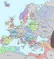
চিত্র:Europe in 1345.png

পাতাটির বিষয়বস্তু অন্যান্য ভাষায় নেই।
এই ফাইলটি উইকিমিডিয়া কমন্স থেকে নেওয়া। মূল পাতাটি দেখতে ক্লিক করুন।
উইকিপিডিয়া, মুক্ত বিশ্বকোষ থেকে

পূর্ণ রেজোলিউশন(১,০৭৫ × ১,১৬৮ পিক্সেল, ফাইলের আকার: ১১৪ কিলোবাইট, এমআইএমই ধরন: image/png)

এই ফাইলটি উইকিমিডিয়া কমন্স থেকে নেওয়া। সেখানের বর্ণনা পাতার বিস্তারিত নিম্নে দেখানো হলো। (সম্পাদনা)
উইকিমিডিয়া কমন্স, মুক্ত লাইসেন্সযুক্ত মিডিয়ার একটি ভান্ডার। আপনি সাহায্য করতে পারেন

সারাংশ

বিবরণ A map of Europe in 1345, showing the location of events that took place in that year. The Black Plague's exact location in unknown, and the shaded area to the right represents rough scholarly estimates. It hit the Crimea in the following year.
তারিখ
উৎস self-made from Image:Europein1328.png with GIMP
লেখক Teaandcrumpets
This historical map image could be re-created using vector graphics as an SVG file. This has several advantages; see Commons:Media for cleanup for more information. If an SVG form of this image is available, please upload it and afterwards replace this template with {{vector version available|new image name}}.


It is recommended to name the SVG file “Europe in 1345.svg”—then the template Vector version available (or Vva) does not need the new image name parameter.
Maps of the history of Europe
BCE
aC

Weichselian ice age (c. 113,000–9700) · Neolithic expansion (c. 7000–4500) · Middle Neolithic (c. 4500–4000) · Late Neolithic (c. 4000–3000) · Copper Age – Corded Ware culture (c. 2900–2350) · Copper Age – Bellbeaker culture (c. 2800–1800) · Early Bronze Age – Unetice culture (c. 2300–1600) · Late Bronze Age – Urnfield culture (c. 1300—750) · Migrations (c. 1000–100) · Hallstatt & La Tène cultures (c. 800–100) · Roman Republic (510–40) · 220 · 218 · 200 · 201–100 · 58 · 49 · 39 · 30 BCE–6 CE


CE
dC

14 · 14–37 · 60 · 60 · 69 · 80 · Migrations 100–500 · 117 · 117 · 125 · Migrations 150–774 · Economy 180 · 271 · 293–305 · 337 · 395 · c. 395 · 400 · 400 · 450 · 457–61 · 476 · 480 · Franks 481–814 · Early Slavs 500–700 · 500 · 526 · 526–600 · Christianisation to 600 · c. 550 · 650 · Pontic Steppe 650 · 665 · 800 · Vikings 800–1050 · 814 · 843–70 · 850 · 900 · 912 · 998 · 1000 · 1000 · 1054 · 1092 · First Crusade 1095–99 · 1097 · 1135 · 1142 · 1147–49 · 1190 · 1190 · 1250 · c. 1250 · 1301-1400 · 1301-1400 · 1328 · 1345 · Black Plague 1347–51 · 1360 · 1400 · Trade routes c. 1400 · 1430 · 1470 · 1490 · 1492 · 1500 · 1519 · 1550 · 1560 · Religion 1560 · Religion 1600 · Religion 1618 · 1618–48 · 1648 · 1683 · 1700 · 1701 · 1708 · 1714 · 1721 · 1725–30 · 1739–1740 · 1740 · 1748–66 · 1783–1792 · 1787 · 1787 · 1789 · 1799 · 1812 · 1812 · 1812 · 1812 · 1813 · 1815 · 1815 · 1815 · 1818 · Ottoman Empire 1830–1923 · 1848–49 · 1861 · 1867 · 1871 · 1878 · 1890 · 1905 · 1911 · 1914 · 1914 · 1919 · 1919–29 · 1923 · 1929 · 1930 · 1940 · 1941–42 · 1942–45 · Cold War 1947–91 · 1950 · 1993–2006 · 2006 to date

(this template: · view · discuss )

লাইসেন্স প্রদান

Public domain আমি, এই কাজের স্বত্বাধিকারী, এতদ্দ্বারা আমি এই কাজকে পাবলিক ডোমেইন লাইসেন্সের আওতায় প্রকাশ করলাম। এটি বিশ্বব্যাপী প্রযোজ্য হবে।
কিছু দেশে এটি আইনত সিদ্ধ নাও হতে পারে, যদি তাই হয়:
আমি যে-কাউকে এই কাজটি যেকোনো উদ্দেশ্যে, বিনাশর্তে ব্যবহারের অনুমতি প্রদান করছি, যদি না সেই শর্তগুলো আইনত প্রয়োজনীয় হয়।

ক্যাপশন

এই ফাইল কি প্রতিনিধিত্ব করছে তার এক লাইন ব্যাখ্যা যোগ করুন

এই ফাইলে চিত্রিত আইটেমগুলি

যা চিত্রিত করে

ফাইলের ইতিহাস

যেকোনো তারিখ/সময়ে ক্লিক করে দেখুন ফাইলটি তখন কী অবস্থায় ছিল।

তারিখ/সময়সংক্ষেপচিত্রমাত্রাব্যবহারকারীমন্তব্য
বর্তমান১৯:৩১, ১০ মে ২০২০১৯:৩১, ১০ মে ২০২০-এর সংস্করণের সংক্ষেপচিত্র১,০৭৫ × ১,১৬৮ (১১৪ কিলোবাইট)Santasa99Corrections per Euroatlas - Historical Maps, http://www.euratlas.net/history/europe/1300/index.html Euratlas Periodis Web - Map of Europe in Year 1300
১২:৫৮, ২৪ ডিসেম্বর ২০১৭১২:৫৮, ২৪ ডিসেম্বর ২০১৭-এর সংস্করণের সংক্ষেপচিত্র১,০৭৫ × ১,১৬৮ (২৮৯ কিলোবাইট)Trey KincaidChanged Sicily who had his own kingdom
১৯:৩০, ১ জুলাই ২০১২১৯:৩০, ১ জুলাই ২০১২-এর সংস্করণের সংক্ষেপচিত্র১,০৭৫ × ১,১৬৮ (২৮২ কিলোবাইট)Ludde23Changed Estonia from the red color of Sweden to the yellow color of Denmark, since Estonia was not Swedish at this time, but belonged to Denmark until 1346.
২১:৩৪, ২৪ এপ্রিল ২০০৯২১:৩৪, ২৪ এপ্রিল ২০০৯-এর সংস্করণের সংক্ষেপচিত্র১,০৭৫ × ১,১৬৮ (১১২ কিলোবাইট)Alex:DBorders corrected
১৮:০২, ১৫ নভেম্বর ২০০৭১৮:০২, ১৫ নভেম্বর ২০০৭-এর সংস্করণের সংক্ষেপচিত্র১,০৭৫ × ১,১৬৮ (১১০ কিলোবাইট)Teaandcrumpets(changed notre dame marker)
২৩:০৩, ১৩ নভেম্বর ২০০৭২৩:০৩, ১৩ নভেম্বর ২০০৭-এর সংস্করণের সংক্ষেপচিত্র১,০৭৫ × ১,১৬৮ (১১৩ কিলোবাইট)Teaandcrumpets{{Information |Description= A map of Europe in 1345, showing the location of events that took place in that year. |Source=self-made from Image:Europein1328.png with GIMP |Date= 13 Nov 2007 |Author= Teaandcrumpets |Permission=

এই ফাইল ব্যবহার করে এমন কোনো পাতা নেই।

ফাইলের বৈশ্বিক ব্যবহার

নিচের অন্যান্য উইকিগুলো এই ফাইলটি ব্যবহার করে:

অধি-উপাত্ত