
চিত্র:De facto cantons of Rojava.png

এই প্রাকদর্শনের আকার: ৭২৫ × ৫৯৯ পিক্সেল। অন্যান্য আকারসমূহ: ২৯০ × ২৪০ পিক্সেল | ৫৮১ × ৪৮০ পিক্সেল | ৯২৯ × ৭৬৮ পিক্সেল | ১,২৩৯ × ১,০২৪ পিক্সেল | ২,০০০ × ১,৬৫৩ পিক্সেল।
পূর্ণ রেজোলিউশন (২,০০০ × ১,৬৫৩ পিক্সেল, ফাইলের আকার: ২৬৮ কিলোবাইট, এমআইএমই ধরন: image/png)
| এই ফাইলটি উইকিমিডিয়া কমন্স থেকে নেওয়া। সেখানের বর্ণনা পাতার বিস্তারিত নিম্নে দেখানো হলো। (সম্পাদনা)
|

|
This map image could be re-created using vector graphics as an SVG file. This has several advantages; see Commons:Media for cleanup for more information. If an SVG form of this image is available, please upload it and afterwards replace this template with
{{vector version available|new image name}}.
It is recommended to name the SVG file “De facto cantons of Rojava.svg”—then the template Vector version available (or Vva) does not need the new image name parameter. |
সারাংশ
| বিবরণ |
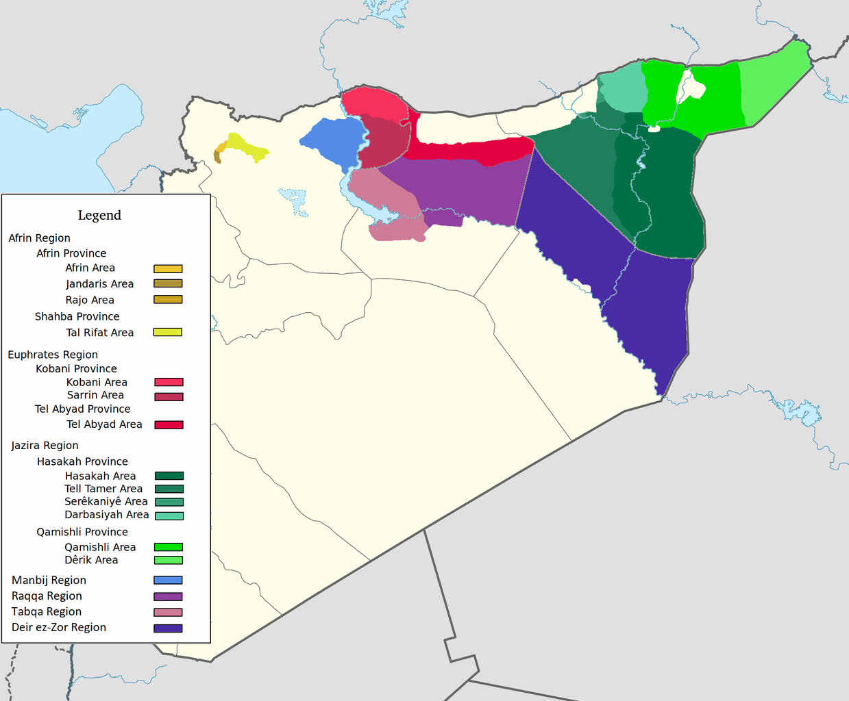
العربية: اقليم عفرين اقليم الفرات اقليم الجزيرة English: Afrin Region Euphrates Region Jazeera Region No region 한국어: 아프린 주 유프라테스 주 자제라 주 없음 |
| তারিখ | |
| উৎস | নিজের কাজ |
| লেখক | Editor abcdef |
| অন্যান্য সংস্করণ |
এই চিত্রের অন্তর্ভুক্ত উপাদানটি  |
লাইসেন্স প্রদান
আমি, এই কাজের স্বত্বাধিকারী, এতদ্দ্বারা আমি এই কাজকে নিম্ন বর্ণিত লাইসেন্সের আওতায় প্রকাশ করলাম:
এই ফাইলটি ক্রিয়েটিভ কমন্স অ্যাট্রিবিউশন-শেয়ার অ্যালাইক ৩.০ আনপোর্টেড লাইসেন্সের আওতায় লাইসেন্সকৃত।
- আপনি স্বাধীনভাবে:
- বণ্টন করতে পারেন – এ কাজটি অনুলিপি, বিতরণ এবং প্রেরণ করতে পারেন
- পুনঃমিশ্রণ করতে পারেন – কাজটি অভিযোজন করতে পারেন
- নিম্নের শর্তাবলীর ভিত্তিতে:
- স্বীকৃতিপ্রদান – আপনাকে অবশ্যই যথাযথ স্বীকৃতি প্রদান করতে হবে, লাইসেন্সের একটি লিঙ্ক সরবরাহ করতে হবে এবং কোনো পরিবর্তন হয়েছে কিনা তা নির্দেশ করতে হবে। আপনি যেকোনো যুক্তিসঙ্গত পদ্ধতিতে এটি করতে পারেন। কিন্তু এমন ভাবে নয়, যাতে প্রকাশ পায় যে লাইসেন্সধারী আপনাকে বা আপনার এই ব্যবহারের জন্য অনুমোদন দিয়েছে।
- একইভাবে বণ্টন – আপনি যদি কাজটি পুনঃমিশ্রণ, রুপান্তর, বা এর ওপর ভিত্তি করে নতুন সৃষ্টিকর্ম তৈরি করেন, তবে আপনাকে অবশ্যই আপনার অবদান একই লাইসেন্স বা একই রকমের লাইসেন্সের আওতায় বিতরণ করতে হবে।
ফাইলের ইতিহাস
যেকোনো তারিখ/সময়ে ক্লিক করে দেখুন ফাইলটি তখন কী অবস্থায় ছিল।
| তারিখ/সময় | সংক্ষেপচিত্র | মাত্রা | ব্যবহারকারী | মন্তব্য | |
|---|---|---|---|---|---|
| বর্তমান | ০৮:২৯, ২৭ মে ২০২০ | | ২,০০০ × ১,৬৫৩ (২৬৮ কিলোবাইট) | AntonSamuel | Reverted to version as of 09:02, 8 April 2020 (UTC) Restoring original map without stripes per COM:OW and discussion on the Rojava talk page on Wikipedia |
| ০৯:০৫, ৮ এপ্রিল ২০২০ |  | ২,০০০ × ১,৬৫৩ (২২৪ কিলোবাইট) | Bill497 | Reverted to version as of 08:59, 8 April 2020 (UTC) Revert vandalism. | |
| ০৯:০২, ৮ এপ্রিল ২০২০ |  | ২,০০০ × ১,৬৫৩ (২৬৮ কিলোবাইট) | AntonSamuel | Reverted to version as of 08:51, 8 April 2020 (UTC) Third, and last warning given on user talk page. | |
| ০৮:৫৯, ৮ এপ্রিল ২০২০ |  | ২,০০০ × ১,৬৫৩ (২২৪ কিলোবাইট) | Bill497 | Reverted to version as of 08:11, 8 April 2020 (UTC) Revert vandalism for a 3rd time. User is reverting a referenced map to an unreferenced version. | |
| ০৮:৫১, ৮ এপ্রিল ২০২০ |  | ২,০০০ × ১,৬৫৩ (২৬৮ কিলোবাইট) | AntonSamuel | Reverted to version as of 17:57, 7 April 2020 (UTC) Once again, use the Rojava talk page to discuss before making reverts and don't throw around unfounded vandalism claims. Second warning on talk page given. | |
| ০৮:১১, ৮ এপ্রিল ২০২০ |  | ২,০০০ × ১,৬৫৩ (২২৪ কিলোবাইট) | Bill497 | Reverted to version as of 11:10, 7 April 2020 (UTC) Revert vandalism. | |
| ১৭:৫৭, ৭ এপ্রিল ২০২০ |  | ২,০০০ × ১,৬৫৩ (২৬৮ কিলোবাইট) | AntonSamuel | Reverted to version as of 00:50, 7 April 2020 (UTC) Restoring viewable version - Use Rojava talk page, warning left on user talk page | |
| ১১:১০, ৭ এপ্রিল ২০২০ |  | ২,০০০ × ১,৬৫৩ (২২৪ কিলোবাইট) | Bill497 | Reverted to version as of 12:33, 2 April 2020 (UTC) Revert attempted vandalism into a factually incorrect version of the map. SDF has entirely no presence in some of the dashed zones. Due to fog of war these areas are all displaced as mixed with government control. Russia is the only reliable source displaying where the government is present. | |
| ০০:৫০, ৭ এপ্রিল ২০২০ |  | ২,০০০ × ১,৬৫৩ (২৬৮ কিলোবাইট) | AntonSamuel | Continuation from below: ...manner. Further sources are needed apart from the Russian military maps - they cannot be considered to be neutral or factually accurate without additional verification. | |
| ০০:৪৬, ৭ এপ্রিল ২০২০ |  | ২,০০০ × ১,৬৫৩ (২১৮ কিলোবাইট) | AntonSamuel | Clearing the 50/50 paint because of the visual difficulty and for deviation from the main purpose of this map - which is to display the various subregions of the civilian administration of the de facto autonomous region, not military control agreements such as SDF-SAA/Russia and SDF-US/US-led coalition which have no known civilian aspect as of date. Please discuss the issue first and foremost on the Rojava talk page if areas with an SAA/Russian or a US presence need to be highlighted in some... |
সংযোগসমূহ
এই ফাইল ব্যবহার করে এমন কোনো পাতা নেই।
ফাইলের বৈশ্বিক ব্যবহার
নিচের অন্যান্য উইকিগুলো এই ফাইলটি ব্যবহার করে:
- ar.wikipedia.org-এ ব্যবহার
- arz.wikipedia.org-এ ব্যবহার
- azb.wikipedia.org-এ ব্যবহার
- ca.wikipedia.org-এ ব্যবহার
- diq.wikipedia.org-এ ব্যবহার
- fa.wikipedia.org-এ ব্যবহার
- glk.wikipedia.org-এ ব্যবহার
- id.wikipedia.org-এ ব্যবহার
- ku.wikipedia.org-এ ব্যবহার
- nl.wikipedia.org-এ ব্যবহার
- ru.wikipedia.org-এ ব্যবহার
- tr.wikipedia.org-এ ব্যবহার
- vi.wikipedia.org-এ ব্যবহার
- www.wikidata.org-এ ব্যবহার
- zh.wikipedia.org-এ ব্যবহার