
চিত্র:Da-ming-hun-yi-tu.jpg

এই প্রাকদর্শনের আকার: ৬৮৩ × ৬০০ পিক্সেল। অন্যান্য আকারসমূহ: ২৭৩ × ২৪০ পিক্সেল | ৫৪৭ × ৪৮০ পিক্সেল | ৮৯৫ × ৭৮৬ পিক্সেল।
পূর্ণ রেজোলিউশন (৮৯৫ × ৭৮৬ পিক্সেল, ফাইলের আকার: ৪৯৩ কিলোবাইট, এমআইএমই ধরন: image/jpeg)
| এই ফাইলটি উইকিমিডিয়া কমন্স থেকে নেওয়া। সেখানের বর্ণনা পাতার বিস্তারিত নিম্নে দেখানো হলো। (সম্পাদনা)
|
সারাংশ
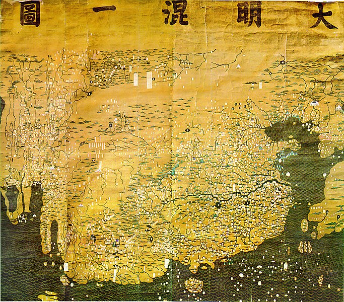
| বিবরণ | The Composite Map of the Ming Empire (Da Ming Hunyi Tu) reflects the political situation in AD 1389 but was likely painted much later. Original Chinese labels were later covered with Manchu on paper slips. |
| তারিখ | ১৩৮৯-এর পরে |
| উৎস | http://geog.hkbu.edu.hk/GEOG1150/Chinese/Catalog/am31_map1.htm |
| লেখক | Chinese (image enhanced by contributor) |
লাইসেন্স প্রদান
|
This is a faithful photographic reproduction of a two-dimensional, public domain work of art. The work of art itself is in the public domain for the following reason:
The official position taken by the Wikimedia Foundation is that "faithful reproductions of two-dimensional public domain works of art are public domain".
This photographic reproduction is therefore also considered to be in the public domain in the United States. In other jurisdictions, re-use of this content may be restricted; see Reuse of PD-Art photographs for details. | ||||
ফাইলের ইতিহাস
যেকোনো তারিখ/সময়ে ক্লিক করে দেখুন ফাইলটি তখন কী অবস্থায় ছিল।
| তারিখ/সময় | সংক্ষেপচিত্র | মাত্রা | ব্যবহারকারী | মন্তব্য | |
|---|---|---|---|---|---|
| বর্তমান | ০১:১৪, ১৭ মার্চ ২০০৮ | | ৮৯৫ × ৭৮৬ (৪৯৩ কিলোবাইট) | David Trochos | {{Information |Description=The Da Ming Hun Yi Tu (Great Ming Dynasty Amalagamated Map), painted on silk in AD 1389 but with Manchu language captions superimposed on paper slips several centuries later, is the oldest surviving Chinese world map. |Source= h |
| ২২:৫৪, ১৬ মার্চ ২০০৮ |  | ৮৯৫ × ৭৮৬ (৪৮৭ কিলোবাইট) | David Trochos | {{Information |Description=The Da Ming Hun Yi Tu (Great Ming Dynasty Amalagamated Map), painted on silk in AD 1389 but with Manchu language captions superimposed on paper slips several centuries later, is the oldest surviving Chinese world map. |Source= h |
সংযোগসমূহ
নিচের পৃষ্ঠা(গুলো) থেকে এই ছবিতে সংযোগ আছে:
ফাইলের বৈশ্বিক ব্যবহার
নিচের অন্যান্য উইকিগুলো এই ফাইলটি ব্যবহার করে:
- de.wikipedia.org-এ ব্যবহার
- en.wikipedia.org-এ ব্যবহার
- es.wikipedia.org-এ ব্যবহার
- fa.wikipedia.org-এ ব্যবহার
- fa.wikibooks.org-এ ব্যবহার
- fr.wikipedia.org-এ ব্যবহার
- hr.wikipedia.org-এ ব্যবহার
- id.wikipedia.org-এ ব্যবহার
- it.wikipedia.org-এ ব্যবহার
- ja.wikipedia.org-এ ব্যবহার
- ko.wikipedia.org-এ ব্যবহার
- sl.wikipedia.org-এ ব্যবহার
- ur.wikipedia.org-এ ব্যবহার
- www.wikidata.org-এ ব্যবহার
- zh.wikipedia.org-এ ব্যবহার