
চিত্র:Carte de la Guyane françoise et l'isle de Cayenne (Bellin, 1763).jpg

এই প্রাকদর্শনের আকার: ৮০০ × ৫৯৫ পিক্সেল। অন্যান্য আকারসমূহ: ৩২০ × ২৩৮ পিক্সেল | ৬৪০ × ৪৭৬ পিক্সেল | ১,০২৪ × ৭৬২ পিক্সেল | ১,২৬৭ × ৯৪৩ পিক্সেল।
পূর্ণ রেজোলিউশন (১,২৬৭ × ৯৪৩ পিক্সেল, ফাইলের আকার: ১.০৮ মেগাবাইট, এমআইএমই ধরন: image/jpeg)
| এই ফাইলটি উইকিমিডিয়া কমন্স থেকে নেওয়া। সেখানের বর্ণনা পাতার বিস্তারিত নিম্নে দেখানো হলো। (সম্পাদনা)
|
.jpg?uselang=bn)
.jpg&action=edit)
সারাংশ
| বিবরণ |
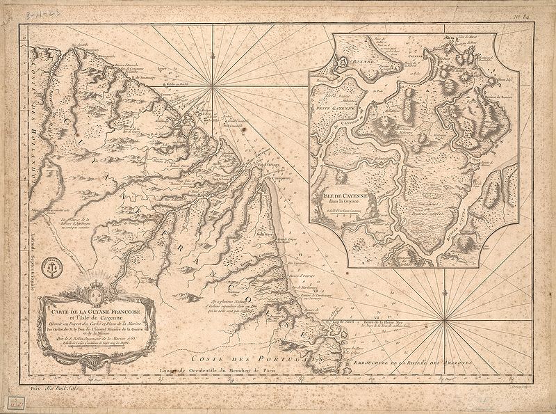
English: This map of French Guiana and the island of Cayenne was made in 1763 by Jacques Bellin (1703-72), a prolific cartographer assigned the Ministry of the French Navy.
Français : Carte de la Guyane françoise et l'isle de Cayenne
Cette carte de la Guyane française et l'île de Cayenne est due à Jacques Bellin (1703-72), un cartographe prolifique affecté au ministère de la Marine française. Elle reflète le soin apporté aux relevés topographiques des baies, des mers et des ports qui caractérisait la cartographie navale française du XVIIIe siècle. En plus d'informations détaillées sur la côte, la carte de Bellin inclut des notes sur l'intérieur de cette partie de l'Amérique du sud, dont l'essentiel restait encore largement inconnu des Européens. |
|||||||||||||||||||
| তারিখ | , Versailles, France | |||||||||||||||||||
| উৎস | Bibliothèque numérique mondiale | |||||||||||||||||||
| লেখক |
|
|||||||||||||||||||
লাইসেন্স প্রদান
|
এই কর্মটি এর উৎস দেশে পাবলিক ডোমেইনে রয়েছে এবং অন্যান্য দেশ ও অঞ্চলে যেখানে কপিরাটের সময়সীমা হচ্ছে লেখকের জীবন যোগ ১০০ বছর বা তাঁর কম। | |
| এই ফাইলটি কপিরাইট আইনের আওতায় জানা সকল বাধানিষেধ মুক্ত বলে চিহ্নিত হয়েছে, যার মধ্যে সম্পর্কিত সকল স্বত্ব ও নেইবারিং সত্ত্ব সংযুক্ত। | |
ফাইলের ইতিহাস
যেকোনো তারিখ/সময়ে ক্লিক করে দেখুন ফাইলটি তখন কী অবস্থায় ছিল।
| তারিখ/সময় | সংক্ষেপচিত্র | মাত্রা | ব্যবহারকারী | মন্তব্য | |
|---|---|---|---|---|---|
| বর্তমান | ২৩:৫১, ২১ এপ্রিল ২০০৯ | | ১,২৬৭ × ৯৪৩ (১.০৮ মেগাবাইট) | Abalg | {{Information |Description={{en|1=This map of French Guiana and the island of Cayenne was made in 1763 by Jacques Bellin (1703-72), a prolific cartographer assigned the Ministry of the French Navy.}} {{fr|1=Carte de la Guyane françoise et l'isle de Cayen |
সংযোগসমূহ
নিচের পৃষ্ঠা(গুলো) থেকে এই ছবিতে সংযোগ আছে:
ফাইলের বৈশ্বিক ব্যবহার
নিচের অন্যান্য উইকিগুলো এই ফাইলটি ব্যবহার করে:
- af.wikipedia.org-এ ব্যবহার
- ar.wikipedia.org-এ ব্যবহার
- br.wikipedia.org-এ ব্যবহার
- en.wikipedia.org-এ ব্যবহার
- es.wikipedia.org-এ ব্যবহার
- fr.wikipedia.org-এ ব্যবহার
- gcr.wikipedia.org-এ ব্যবহার
- he.wikipedia.org-এ ব্যবহার
- it.wikipedia.org-এ ব্যবহার
- pt.wikipedia.org-এ ব্যবহার
- ru.wikipedia.org-এ ব্যবহার
- sr.wikipedia.org-এ ব্যবহার
- vi.wikipedia.org-এ ব্যবহার
- www.wikidata.org-এ ব্যবহার
.jpg)