
চিত্র:CaminoRealAdentro.png
এই প্রাকদর্শনের আকার: ৬১৪ × ৬০০ পিক্সেল। অন্যান্য আকারসমূহ: ২৪৬ × ২৪০ পিক্সেল | ৪৯১ × ৪৮০ পিক্সেল | ৬৯৮ × ৬৮২ পিক্সেল।
পূর্ণ রেজোলিউশন (৬৯৮ × ৬৮২ পিক্সেল, ফাইলের আকার: ৩৭৪ কিলোবাইট, এমআইএমই ধরন: image/png)
| এই ফাইলটি উইকিমিডিয়া কমন্স থেকে নেওয়া। সেখানের বর্ণনা পাতার বিস্তারিত নিম্নে দেখানো হলো। (সম্পাদনা)
|
সারাংশ
| বিবরণ |
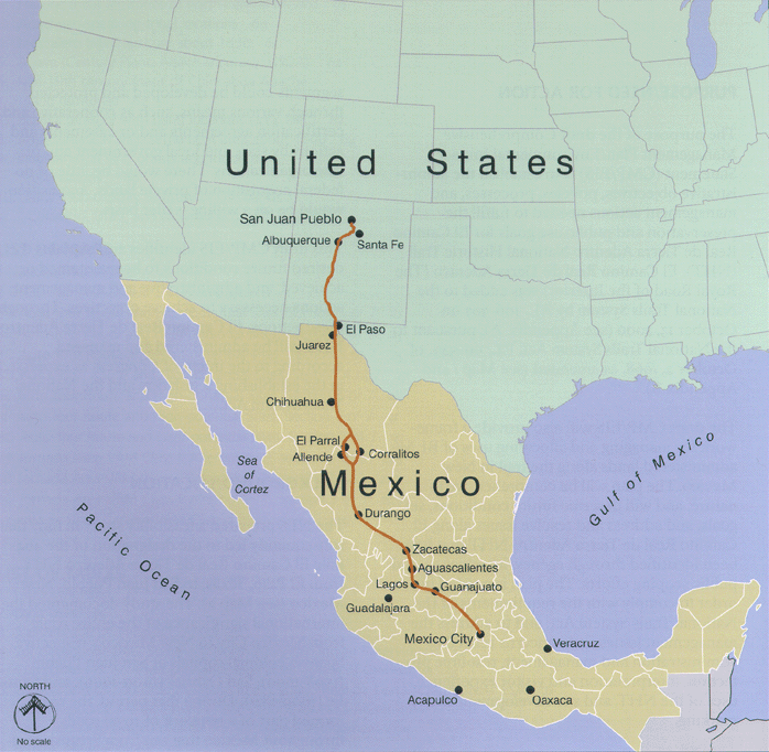
English: Map of Camino Real de Adentro of the Spanish Viceroyalty of New Spain:
Español: Mapa del Camino Real de Tierra Adentro del Virreinato de Nueva España:
|
| উৎস | http://www.nps.gov/elca |
| লেখক | U.S. National Park Service |

|
This map image could be re-created using vector graphics as an SVG file. This has several advantages; see Commons:Media for cleanup for more information. If an SVG form of this image is available, please upload it and afterwards replace this template with
{{vector version available|new image name}}.
It is recommended to name the SVG file “CaminoRealAdentro.svg”—then the template Vector version available (or Vva) does not need the new image name parameter. |
লাইসেন্স প্রদান
| This image or media file contains material based on a work of a National Park Service employee, created as part of that person's official duties. As a work of the U.S. federal government, such work is in the public domain in the United States. See the NPS website and NPS copyright policy for more information. |
মূল আপলোড লগ
| তারিখ/সময় | মাত্রা | ব্যবহারকারী | মন্তব্য |
|---|---|---|---|
| ২৪ জুলাই ২০০৮, ০৬:২৮:০৪ | 698 × 682 (250345 bytes) | Arturoramos (আলোচনা · অবদান) | {{Information |Description={{en|1=Map of Camino Real de Adentro in Colonial Mexico running from Mexico City to Santa Fe and San Juan, New Mexico}} |Source=http://www.nps.gov/elca |Author=U.S. Natiional Park Service |Date= |Permission= |other_versions= }} |
ফাইলের ইতিহাস
যেকোনো তারিখ/সময়ে ক্লিক করে দেখুন ফাইলটি তখন কী অবস্থায় ছিল।
| তারিখ/সময় | সংক্ষেপচিত্র | মাত্রা | ব্যবহারকারী | মন্তব্য | |
|---|---|---|---|---|---|
| বর্তমান | ০৭:৫৭, ২৯ আগস্ট ২০১৪ | | ৬৯৮ × ৬৮২ (৩৭৪ কিলোবাইট) | GifTagger | Bot: Converting file to superior PNG file. (Source: CaminoRealAdentro.gif). This GIF was problematic due to non-greyscale color table. |
সংযোগসমূহ
নিচের পৃষ্ঠা(গুলো) থেকে এই ছবিতে সংযোগ আছে:
ফাইলের বৈশ্বিক ব্যবহার
নিচের অন্যান্য উইকিগুলো এই ফাইলটি ব্যবহার করে:
- ast.wikipedia.org-এ ব্যবহার
- az.wikipedia.org-এ ব্যবহার
- be.wikipedia.org-এ ব্যবহার
- ca.wikipedia.org-এ ব্যবহার
- cs.wikipedia.org-এ ব্যবহার
- de.wikipedia.org-এ ব্যবহার
- en.wikipedia.org-এ ব্যবহার
- en.wikivoyage.org-এ ব্যবহার
- eo.wikipedia.org-এ ব্যবহার
- es.wikipedia.org-এ ব্যবহার
- Zacatecas
- Conquista de México
- Apaseo el Grande
- Anexo:Patrimonio de la Humanidad en América Latina y el Caribe
- Camino Real de Tierra Adentro
- Anexo:Patrimonio de la Humanidad en México
- Usuario:Vivero/revisiónconquista
- Sistema nacional de senderos de los Estados Unidos
- Usuario:Feuerfluss/taller
- Usuario:Xexito/Taller
- fr.wikipedia.org-এ ব্যবহার
- fr.wikivoyage.org-এ ব্যবহার
- he.wikipedia.org-এ ব্যবহার
- hr.wikipedia.org-এ ব্যবহার
- hy.wikipedia.org-এ ব্যবহার
- it.wikipedia.org-এ ব্যবহার
- it.wikivoyage.org-এ ব্যবহার
- ja.wikipedia.org-এ ব্যবহার
- ka.wikipedia.org-এ ব্যবহার
- kk.wikipedia.org-এ ব্যবহার
- lt.wikipedia.org-এ ব্যবহার
- mt.wikipedia.org-এ ব্যবহার
- nl.wikipedia.org-এ ব্যবহার
- no.wikipedia.org-এ ব্যবহার
- pt.wikipedia.org-এ ব্যবহার
- ru.wikipedia.org-এ ব্যবহার
এই ফাইলের অন্যান্য বৈশ্বিক ব্যবহার দেখুন।