
চিত্র:1806 Cary Map of Florida, Georgia, North Carolina, South Carolina and Tennessee - Geographicus - NCSCGAFL-cary-1806.jpg

এই প্রাকদর্শনের আকার: ৬৭৪ × ৫৯৯ পিক্সেল। অন্যান্য আকারসমূহ: ২৭০ × ২৪০ পিক্সেল | ৫৪০ × ৪৮০ পিক্সেল | ৮৬৪ × ৭৬৮ পিক্সেল | ১,১৫১ × ১,০২৪ পিক্সেল | ২,৩০৩ × ২,০৪৮ পিক্সেল | ৫,০০০ × ৪,৪৪৭ পিক্সেল।
পূর্ণ রেজোলিউশন (৫,০০০ × ৪,৪৪৭ পিক্সেল, ফাইলের আকার: ৭.৪৪ মেগাবাইট, এমআইএমই ধরন: image/jpeg)
| এই ফাইলটি উইকিমিডিয়া কমন্স থেকে নেওয়া। সেখানের বর্ণনা পাতার বিস্তারিত নিম্নে দেখানো হলো। (সম্পাদনা)
|
সারাংশ
| John Cary: A New Map of Part of the United States of North America, Containing the Carolinas and Georgia, also the Floridas and Part of the Bahama Islands &c.
( |
||||||||||||||||||||||||||
|---|---|---|---|---|---|---|---|---|---|---|---|---|---|---|---|---|---|---|---|---|---|---|---|---|---|---|
| শিল্পী |
|
|||||||||||||||||||||||||
| শিরোনাম |
A New Map of Part of the United States of North America, Containing the Carolinas and Georgia, also the Floridas and Part of the Bahama Islands &c. |
|||||||||||||||||||||||||
| বিবরণ |
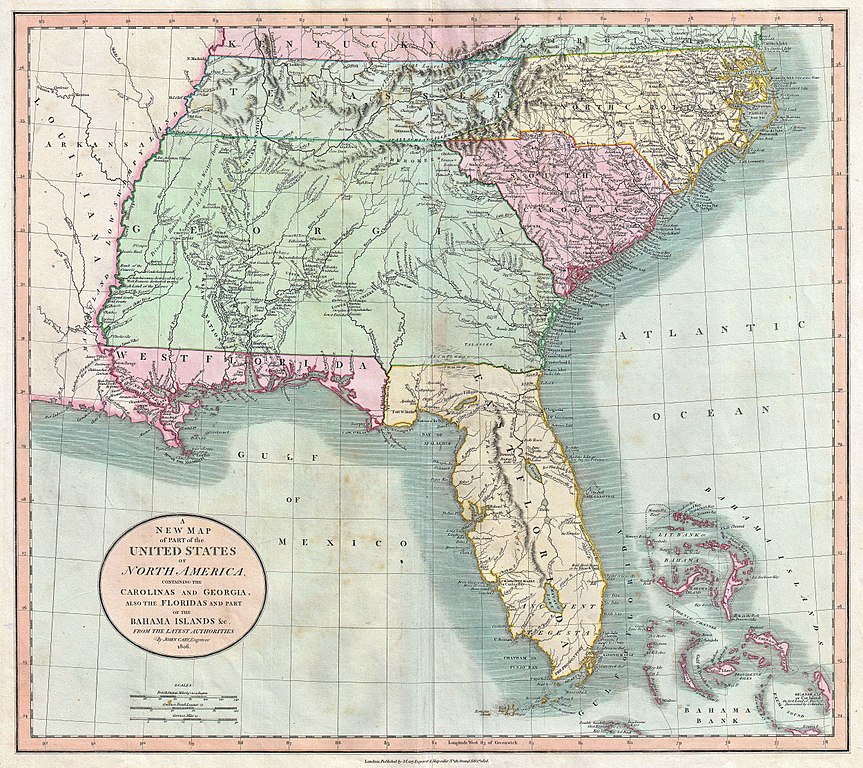
English: Published by John Cary in 1805, this is one of the most interesting and attractive maps of the American southeast to appear in the first years of the 19th century. Covers from Kentucky and Virginia South include all of modern day North Carolina, South Carolina, Tennessee, Georgia, Alabama, Mississippi and Florida. Georgia is shown extending westward as far as the Mississippi River despite the creation of the Mississippi Territory in 1798. Florida is divided at the Appalachicola River into eastern and western sections. West Florida, ostensibly part of the Louisiana Purchase, was claimed by the Spanish and remained under their control until 1812. (See West Florida Controversy.) Southern Florida is labeled “Ancient Tegesta” according to the 18th century convention. Tegesta is a name of somewhat mysterious origins that appears on maps of Florida as early as the 1600s. It most likely refers to a vanished American Indian tribe or abandoned village located near what is today Miami. Offers copious notations and comments throughout, most of which are extremely interesting. Identifies the locations of numerous American Indian nations including the Creeks, the Chicksaw Nation, the Cherokees and others. Notes the abandoned Applachee Villages in northern Florida. Also offers notes on American Indian hunting grounds, springs, river navigation, roads, swamps, forts and the sites of important battles. All-in-all a wonderful example of a rare and important map of the American southeast. Prepared in 1806 by John Cary for issue in his magnificent 1808 New Universal Atlas . |
|||||||||||||||||||||||||
| তারিখ | ১৮০৬ (dated) | |||||||||||||||||||||||||
| আকার | উচ্চতা: ১৮.৫ ইঞ্চি (৪৬.৯ সে.মি.); প্রস্থ: ২০.৫ ইঞ্চি (৫২.০ সে.মি.) | |||||||||||||||||||||||||
| সংযোজন সংখ্যা |
Geographicus link: NCSCGAFL-cary-1806 |
|||||||||||||||||||||||||
| উৎস/আলোকচিত্রগ্রাহক |
Cary, John, Cary's New Universal Atlas, containing distinct maps of all the principal states and kingdoms throughout the World. From the latest and best authorities extant. London: Printed for J. Cary, Engraver and Map-seller, No. 181, near Norfolk Street, Strand, 1808.
|
|||||||||||||||||||||||||
| অনুমতি (এ ফাইলের পুনঃব্যবহার) |
|
|||||||||||||||||||||||||
ফাইলের ইতিহাস
যেকোনো তারিখ/সময়ে ক্লিক করে দেখুন ফাইলটি তখন কী অবস্থায় ছিল।
| তারিখ/সময় | সংক্ষেপচিত্র | মাত্রা | ব্যবহারকারী | মন্তব্য | |
|---|---|---|---|---|---|
| বর্তমান | ০৯:৩৫, ২২ মার্চ ২০১১ | | ৫,০০০ × ৪,৪৪৭ (৭.৪৪ মেগাবাইট) | BotMultichill | {{subst:User:Multichill/Geographicus |link=http://www.geographicus.com/P/AntiqueMap/NCSCGAFL-cary-1806 |product_name=1806 Cary Map of Florida, Georgia, North Carolina, South Carolina and Tennessee |map_title=A New Map of Part of the United States of Nort |
সংযোগসমূহ
নিচের পৃষ্ঠা(গুলো) থেকে এই ছবিতে সংযোগ আছে:
ফাইলের বৈশ্বিক ব্যবহার
নিচের অন্যান্য উইকিগুলো এই ফাইলটি ব্যবহার করে:
- da.wikipedia.org-এ ব্যবহার
- en.wikipedia.org-এ ব্যবহার
- he.wikipedia.org-এ ব্যবহার
- it.wikipedia.org-এ ব্যবহার
- mt.wikipedia.org-এ ব্যবহার