
চিত্র:1632 Cardona Descripcion Indias (11).jpg

পূর্ণ রেজোলিউশন (২,৯৩০ × ১,৯৫৩ পিক্সেল, ফাইলের আকার: ৫২৪ কিলোবাইট, এমআইএমই ধরন: image/jpeg)
| এই ফাইলটি উইকিমিডিয়া কমন্স থেকে নেওয়া। সেখানের বর্ণনা পাতার বিস্তারিত নিম্নে দেখানো হলো। (সম্পাদনা)
|
.jpg?uselang=bn)
.jpg&action=edit)
সারাংশ
| বিবরণ |
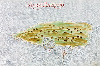
Español: Mapa español de 1632 de la isla del Barbado (actual Barbados). Página 11 de las Descripciones geográficas e hidrográficas de muchas tierras y mares del Norte y Sur en las Indias, en especial del descubrimiento del Reino de la California redactadas por el capitán Nicolás de Cardona tras su expedición de 1614.
English: Spanish 1632 map of the island of Barbados. Page 11 of the Descripciones geográficas e hidrográficas de muchas tierras y mares del Norte y Sur en las Indias, en especial del descubrimiento del Reino de la California (Geographic and hydrographic descriptions of many northern and southern lands and seas in the Indies, specifically the discovery of the kingdom of California), written by captain Nicolás de Cardona after his expedition of 1614. |
|||||||||||||||||||
| তারিখ | ||||||||||||||||||||
| উৎস |
Descripciones geográficas e hidrográficas de muchas tierras y mares del Norte y Sur en las Indias, en especial del descubrimiento del Reino de California hecho con trabajo e industria por el capitán y cabo Nicolás de Cardona ... dirigidas al Exmo. D. Gaspar de Guzmán, Conde de Olivares ... Biblioteca Digital Hispánica (Biblioteca Nacional de España) |
|||||||||||||||||||
| লেখক |
|
|||||||||||||||||||
লাইসেন্স প্রদান
|
This is a faithful photographic reproduction of a two-dimensional, public domain work of art. The work of art itself is in the public domain for the following reason:
The official position taken by the Wikimedia Foundation is that "faithful reproductions of two-dimensional public domain works of art are public domain".
This photographic reproduction is therefore also considered to be in the public domain in the United States. In other jurisdictions, re-use of this content may be restricted; see Reuse of PD-Art photographs for details. | ||||
ফাইলের ইতিহাস
যেকোনো তারিখ/সময়ে ক্লিক করে দেখুন ফাইলটি তখন কী অবস্থায় ছিল।
| তারিখ/সময় | সংক্ষেপচিত্র | মাত্রা | ব্যবহারকারী | মন্তব্য | |
|---|---|---|---|---|---|
| বর্তমান | ১৮:২৬, ১৮ সেপ্টেম্বর ২০২৩ | | ২,৯৩০ × ১,৯৫৩ (৫২৪ কিলোবাইট) | Beao | Cropped 8 % horizontally, 10 % vertically using CropTool with lossless mode. Removed watermark. |
| ২৩:২৯, ৫ মার্চ ২০১৬ |  | ৩,১৮৪ × ২,১৬৫ (৬৫০ কিলোবাইট) | Hispalois | User created page with UploadWizard |
সংযোগসমূহ
নিচের পৃষ্ঠা(গুলো) থেকে এই ছবিতে সংযোগ আছে:
ফাইলের বৈশ্বিক ব্যবহার
নিচের অন্যান্য উইকিগুলো এই ফাইলটি ব্যবহার করে:
- arz.wikipedia.org-এ ব্যবহার
- as.wikipedia.org-এ ব্যবহার
- be-tarask.wikipedia.org-এ ব্যবহার
- ceb.wikipedia.org-এ ব্যবহার
- cs.wikipedia.org-এ ব্যবহার
- el.wikipedia.org-এ ব্যবহার
- en.wikipedia.org-এ ব্যবহার
- es.wikipedia.org-এ ব্যবহার
- eu.wikipedia.org-এ ব্যবহার
- fr.wikipedia.org-এ ব্যবহার
- he.wikipedia.org-এ ব্যবহার
- hy.wikipedia.org-এ ব্যবহার
- id.wikipedia.org-এ ব্যবহার
- io.wikipedia.org-এ ব্যবহার
- ka.wikipedia.org-এ ব্যবহার
- ru.wikipedia.org-এ ব্যবহার
- uk.wikipedia.org-এ ব্যবহার
.jpg)