
চিত্র:2007 North Indian Ocean cyclone season summary.jpg

এই প্রাকদর্শনের আকার: ৮০০ × ৪৯৪ পিক্সেল। অন্যান্য আকারসমূহ: ৩২০ × ১৯৮ পিক্সেল | ৬৪০ × ৩৯৬ পিক্সেল | ১,০২৪ × ৬৩৩ পিক্সেল | ১,২৮০ × ৭৯১ পিক্সেল | ৩,০০০ × ১,৮৫৪ পিক্সেল।
পূর্ণ রেজোলিউশন (৩,০০০ × ১,৮৫৪ পিক্সেল, ফাইলের আকার: ৬৫৭ কিলোবাইট, এমআইএমই ধরন: image/jpeg)
| এই ফাইলটি উইকিমিডিয়া কমন্স থেকে নেওয়া। সেখানের বর্ণনা পাতার বিস্তারিত নিম্নে দেখানো হলো। (সম্পাদনা)
|
| বিবরণ |
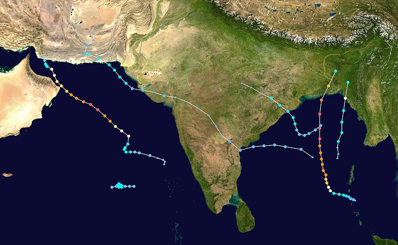
English: This map shows the tracks of all tropical cyclones in the 2007 North Indian Ocean cyclone season. The points show the location of each storm at 6-hour intervals. The colour represents the storm's maximum sustained wind speeds as classified in the Saffir-Simpson Hurricane Scale (see below), and the shape of the data points represent the type of the storm.
Tropical depression (≤38 mph, ≤62 km/h)
Tropical storm (39–73 mph, 63–118 km/h)
Category 1 (74–95 mph, 119–153 km/h)
Category 2 (96–110 mph, 154–177 km/h)
Category 3 (111–129 mph, 178–208 km/h)
Category 4 (130–156 mph, 209–251 km/h)
Category 5 (≥157 mph, ≥252 km/h)
Unknown
Storm type |
| উৎস | Created using Wikipedia:WikiProject Tropical cyclones/Tracks. The background image is from NASA [1]. The tracking data is from the Joint Typhoon Warning Center's best track database |
| লেখক | Potapych |

|
নতুন তথ্য প্রতিফলিত করতে এই ফাইলটি হালনাগাদ করা হতে পারে। আপনি যদি নতুন হালনাগাদ প্রতিফলিত করে না, ফাইলটির এমন একটি নির্দিষ্ট সংস্করণ ব্যবহার করতে চান তবে অনুগ্রহ করে একটি পৃথক ফাইল হিসাবে প্রয়োজনীয় সংস্করণটি আপলোড করুন। |
| এই কাজের প্রণেতা Potapych কাজটি পাবলিক ডোমেইনে প্রকাশ করেছেন। এটি বিশ্বব্যাপী প্রযোজ্য হবে। কিছু দেশে এটি আইনত সিদ্ধ নাও হতে পারে, যদি তাই হয়: Potapych যে-কাউকে যেকোনো উদ্দেশ্যে, বিনাশর্তে এই কাজটি ব্যবহারের অনুমতি প্রদান করেন, যদি না সেই শর্তগুলো আইনত প্রয়োজনীয় হয়। |
ফাইলের ইতিহাস
যেকোনো তারিখ/সময়ে ক্লিক করে দেখুন ফাইলটি তখন কী অবস্থায় ছিল।
| তারিখ/সময় | সংক্ষেপচিত্র | মাত্রা | ব্যবহারকারী | মন্তব্য | |
|---|---|---|---|---|---|
| বর্তমান | ০৭:৫৮, ১২ ডিসেম্বর ২০০৮ | | ৩,০০০ × ১,৮৫৪ (৬৫৭ কিলোবাইট) | Potapych | larger size |
| ১৬:৩৩, ২৯ নভেম্বর ২০০৮ |  | ১,৩৬৭ × ৭৯০ (১৯০ কিলোবাইট) | Ramisses | This map shows the tracks of all tropical cyclones in the 2007 North Indian Ocean cyclone season. {{PD-user|Ramisses}} * Background image from [[:Image:Whole world - land and oceans.jpg| |
সংযোগসমূহ
নিচের পৃষ্ঠা(গুলো) থেকে এই ছবিতে সংযোগ আছে:
ফাইলের বৈশ্বিক ব্যবহার
নিচের অন্যান্য উইকিগুলো এই ফাইলটি ব্যবহার করে:
- de.wikipedia.org-এ ব্যবহার
- en.wikipedia.org-এ ব্যবহার
- pt.wikipedia.org-এ ব্যবহার
- zh.wikipedia.org-এ ব্যবহার