
বিশ্বের মানচিত্র

এতে ত্রুটি তুলনামূলক অনেক কম রয়েছে।[১] এমনকি, এটিকে ন্যাশনাল জিওগ্রাফিক সোসাইটি উদ্ধৃতি মানচিত্র হিসেবে গ্রহণ করেছে।

বিশ্বের মানচিত্র হচ্ছে পৃথিবীর পৃষ্ঠের বেশিরভাগ বা সমস্ত অংশের একটি মানচিত্র। বিশ্বের মানচিত্রগুলোকে পৃথিবীর স্কেলের কারণে অভিক্ষেপণ সমস্যার মোকাবেলা করতে হয়। প্রয়োজন অনুসারে দুটি মাত্রায় রেন্ডার করা মানচিত্র পৃথিবীর ত্রিমাত্রিক পৃষ্ঠের প্রদর্শনকে বিকৃত করে। যদিও এটি যেকোনো মানচিত্রের ক্ষেত্রে সত্য, কিন্তু এই বিকৃতিগুলো বিশ্বের মানচিত্রে খুব বেশি হয়ে থাকে। বিশ্বের মানচিত্র উপস্থাপন করার জন্য অনেক কৌশল তৈরি করা হয়েছে যা বিভিন্ন প্রযুক্তিগত এবং নান্দনিক লক্ষ্যগুলোকে সম্বোধন করে।[২]
একটি বিশ্ব মানচিত্র বর্ণনাচিত্র তৈরি করার জন্য পৃথিবী, এর মহাসাগর এবং এর মহাদেশগুলোর বৈশ্বিক জ্ঞান প্রয়োজন। প্রাগৈতিহাসিক সময়কাল থেকে মধ্যযুগ পর্যন্ত সঠিক বিশ্বের মানচিত্র তৈরি করা অসম্ভব ছিল। কারণ যে কোনো সংস্কৃতির কাছে পৃথিবীর অর্ধেকেরও কম উপকূলরেখা এবং এর মহাদেশীয় অভ্যন্তরীণ অংশের একটি ছোট অংশ পরিচিত ছিল। ইউরোপীয় রেনেসাঁ সময় শুরু হওয়ার সময়ে গবেষণার সাথে সাথে পৃথিবীর পৃষ্ঠের জ্ঞান দ্রুত সঞ্চিত হয়। যার ফলে পৃথিবীর বেশিরভাগ উপকূলরেখার মানচিত্র ১৭৫০ এর দশকের মধ্যে তৈরি করা হয়েছিল। আর বিংশ শতাব্দীর মধ্যে মহাদেশীয় অভ্যন্তরীণ মানচিত্র তৈরি করা সম্ভব হয়েছিল।
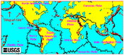
বিশ্বের মানচিত্র সাধারণত রাজনৈতিক বৈশিষ্ট্য বা ভৌত বৈশিষ্ট্যের উপর ফোকাস করে। রাজনৈতিক মানচিত্র আঞ্চলিক সীমানা এবং মানব বসতির চিত্রায়নে জোর দেয়। ভৌত মানচিত্র দেখায় ভৌগোলিক বৈশিষ্ট্য; যেমন- পর্বত, মাটির ধরন বা ভূমির ব্যবহার। ভূতাত্ত্বিক মানচিত্র পৃষ্ঠকে দেখানোর পাশাপাশি অন্তর্নিহিত শিলাগুলোর বৈশিষ্ট্য, ভৌগোলিক ত্রুটি ও ভূপৃষ্ঠের কাঠামো প্রদর্শন করে। চোরোপ্লেথ মানচিত্র[সন্দেহজনক অনুবাদ] অঞ্চলগুলোর মধ্যে জনসংখ্যা ও অর্থনৈতিক পরিসংখ্যান হিসেবে পার্থক্যের জন্য হালকা রঙ এবং গাঢ় রঙ ব্যবহার করে।
মানচিত্র অভিক্ষেপসমূহ[সম্পাদনা]
বিশ্বের মানচিত্রগুলো বেশ কয়েকটি মানচিত্রের অনুমানের উপর ভিত্তি করে বা সমতলে গোলক প্রতিনিধিত্ব করার পদ্ধতির উপর ভিত্তি করে তৈরি করা হয়। সমস্ত অনুমান ভৌগোলিক বৈশিষ্ট্য, দূরত্ব এবং দিকনির্দেশকে কোনো না কোনোভাবে বিকৃত করে। বিকশিত বিভিন্ন মানচিত্রের অনুমানগুলি বিশ্ব মানচিত্র তৈরিতে অন্তর্নিহিত নির্ভুলতা এবং অনিবার্য বিকৃতির ভারসাম্য বজায় রাখার বিভিন্ন উপায় সরবরাহ করে।
সম্ভবত সবচেয়ে পরিচিত অভিক্ষেপ হল মার্কেটর অভিক্ষেপ, যা মূলত একটি নটিক্যাল চার্ট হিসেবে চিত্রিত করা হয়েছে।
-
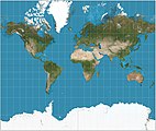 মার্কেটর অভিক্ষেপ
(৮২°দক্ষিণ ও ৮২°উত্তর) -
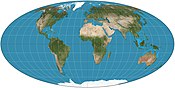 মলওয়েড অভিক্ষেপ
 -
 বি. জে. এস. কাহিল প্রজাপতি মানচিত্র, ১৯০৯। ১৯১৯ সালের বাঁধাই না করা নথিপত্র থেকে।
 -
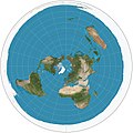 পোলার অ্যাজিমুথাল ইকুয়িডিস্ট্যান্ট অভিক্ষেপ
 -
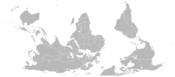 একটি মানচিত্র, যেটির দক্ষিণ উপরের দিকে।
 -
-
 গল-পিটার্স অভিক্ষেপ, একটি সমান-ক্ষেত্রের মানচিত্র অভিক্ষেপ
 -
 রবিনসন অভিক্ষেপ, অতীতে ন্যাশনাল জিওগ্রাফিক সোসাইটি কর্তৃক ব্যবহৃত।


বিষয়ভিত্তিক মানচিত্র[সম্পাদনা]
একটি বিষয়ভিত্তিক মানচিত্র এক বা কয়েকটি কেন্দ্রীভূত বিষয় সম্পর্কে ভৌগোলিক তথ্য দেখায়। এই মানচিত্রগুলো "শহর, রাজ্য, অঞ্চল, জাতি বা মহাদেশের ভৌত, সামাজিক, রাজনৈতিক, সাংস্কৃতিক, অর্থনৈতিক, সমাজতাত্ত্বিক, কৃষি বা অন্য কোন দিকগুলোকে চিত্রিত করতে পারে"।[৩]
-
 ক্লিকযোগ্য বিশ্বের মানচিত্র(জলবায়ু শ্রেণীবিভাগসহ)
 -
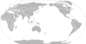
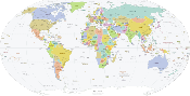 একটি সহজ রাজনৈতিক বিশ্ব মানচিত্র
 -
 বিশ্বের স্থান বিবরণ সংক্রান্ত বিশ্ব মানচিত্র
 -
 দেশ অনুসারে নৃতাত্ত্বিক কার্বন ডাই অক্সাইড২ নির্গমনের মানচিত্র
 -
 জাতিসংঘের দেশ অনুসারে মানব উন্নয়ন সূচক (২০১৬ অনুযায়)
 -
 আয়ুষ্কাল অনুযায়ী বিশ্ব মানচিত্র
 -
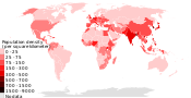 ২০১৮ জনসংখ্যার ঘনত্ব (জন প্রতি বর্গ কি.মি., দেশ অনুসারে)
 -
 আগ্নেয়গিরির মানচিত্র
 -
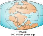 বিশ্বের মানচিত্র প্রায় ২০০ মিলিয়ন বছর আগে মহাদেশগুলো দেখাচ্ছে (ট্রায়াসিক সময়কাল)
 -
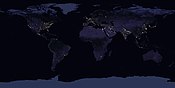 রাতে পৃথিবীর স্যাটেলাইট ছবি।

.svg)


ঐতিহাসিক মানচিত্র[সম্পাদনা]
ঐতিহাসিক বিশ্ব মানচিত্র দ্বারা লৌহ যুগ থেকে আবিষ্কারের যুগ এবং আধুনিক ভূগোলের আবির্ভাবের প্রথম আধুনিক যুগে বিশ্বের চিত্রগুলোকে বুঝায়। পুরানো মানচিত্রগুলো অতীতে পরিচিত স্থানগুলোর পাশাপাশি মানচিত্রের দার্শনিক এবং সাংস্কৃতিক ভিত্তি সম্পর্কে তথ্য প্রদান করে, যা অনেকটাই আধুনিক কার্টোগ্রাফি থেকে অনেক আলাদা ছিল। মানচিত্র হল একটি মাধ্যম যার মাধ্যমে বিজ্ঞানীরা তাদের ধারণা বিতরণ এবং ভবিষ্যৎ প্রজন্মের কাছে প্রেরণ করেছেন।[৪]
-
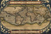 পৃথিবী, আব্রাহাম ওর্টেলিয়াসের টাইপাস অরবিস টেররারাম থেকে। ১৫৬৪ খ্রিস্টাব্দে প্রথম প্রকাশিত।
 -
 অ্যানাক্সিম্যান্ডারের (৬১০-৫৪৬ খ্রিস্টপূর্ব) বিশ্বের মানচিত্রের অনুমানমূলক পুনর্গঠন
 -
 বিশ্বের মানচিত্র পসিডোনিয়াসের অনুসারে (১৫০–১৩০ খ্রিস্টপূর্ব),
১৬২৮ খ্রিস্টাব্দে অঙ্কিত -
 মধ্যযুগীয় টি-এন্ড-ও মানচিত্রের আদর্শ পুনর্গঠন (মেয়ার্স কনভারসেশনলেক্সিকন থেকে, ১৮৯৫) (এশিয়া ডানদিকে দেখানো হয়েছে)
 -
 ১১৫৪ সালে মুহাম্মদ আল-ইদ্রিসি দ্বারা টেবুলা রোজেরিয়ানা বিশ্ব মানচিত্র। দ্র. উত্তর নিচের দিকে।
 -
 লিওনার্দো দা ভিঞ্চির উইন্ডসরের কাগজপত্র থেকে অক্ট্যান্ট অভিক্ষেপের (১৫১৪) বিশ্বের মানচিত্র
 -
 গ্যারাডাস মার্কেটর (১৫৬৯) দ্বারা বিশ্ব মানচিত্র, সুপরিচিত মার্কেটর অভিক্ষেপের প্রথম মানচিত্র
 -
 ক্লিস জ্যানসজুন ভিসশারের বিশ্ব মানচিত্র (১৬৫২)
 -
 জেরার্ড ভ্যান শ্যাগেনের বিশ্বের একটি ঐতিহাসিক মানচিত্র, ১৬৮৯


আরও দেখুন[সম্পাদনা]
- উইকিপিডিয়ার ক্লিকযোগ্য বিশ্ব মানচিত্র
- পৃথিবীর মানচিত্রসমূহ
- মানচিত্র
- বিশ্ব
তথ্যসূত্র[সম্পাদনা]
- ↑ Large-Scale Distortions in Map Projections, 2007, David M. Goldberg & J. Richard Gott III, 2007, V42 N4.
- ↑ American Cartographic Association's Committee on Map Projections (১৯৮৮)। Choosing a World Map। Falls Church: American Congress on Surveying and Mapping। পৃষ্ঠা 1–2।
- ↑ Thematic Maps ওয়েব্যাক মেশিনে আর্কাইভকৃত ৭ সেপ্টেম্বর ২০১২ তারিখে Map Collection & Cartographic Information Services Unit. University Library, University of Washington. Accessed 27 December 2009.
- ↑ "History of maps and cartography"। emporia.edu। ৯ জুলাই ২০১১ তারিখে মূল থেকে আর্কাইভ করা। সংগ্রহের তারিখ ১০ ফেব্রুয়ারি ২০২২।