
চিত্র:Sint Maarten location map.svg

এই SVG ফাইলের জন্য এই PNG প্রাকদর্শনের আকার: ৮০০ × ৫৭৮ পিক্সেল। অন্যান্য আকারসমূহ: ৩২০ × ২৩১ পিক্সেল | ৬৪০ × ৪৬২ পিক্সেল | ১,০২৪ × ৭৪০ পিক্সেল | ১,২৮০ × ৯২৫ পিক্সেল | ২,৫৬০ × ১,৮৫০ পিক্সেল | ১,১৭৫ × ৮৪৯ পিক্সেল।
পূর্ণ রেজোলিউশন (এসভিজি ফাইল, সাধারণত ১,১৭৫ × ৮৪৯ পিক্সেল, ফাইলের আকার: ১৪৫ কিলোবাইট)
| এই ফাইলটি উইকিমিডিয়া কমন্স থেকে নেওয়া। সেখানের বর্ণনা পাতার বিস্তারিত নিম্নে দেখানো হলো। (সম্পাদনা)
|
সারাংশ
| ক্যামেরার অবস্থান | | এটি এবং অন্যান্য ছবি তাদের অবস্থানের উপর: ওপেনস্ট্রিটম্যাপ |
|---|
| বিবরণ |
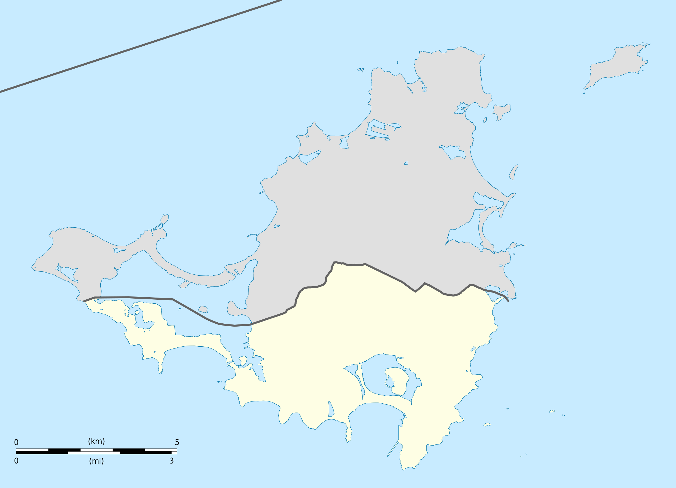
English: Blank administrative map of Sint Maarten, constituent country of the Kingdom of the Netherlands, for geo-location purpose.
Français : Carte administrative vierge de Sint Maarten, État du Royaume des Pays-Bas, destinée à la géolocalisation. Estimated scale: 1:200,000 (precision: 50 m)
Geographic limits of the map:
|
||
| তারিখ | |||
| উৎস |
নিজের কাজ
|
||
| লেখক | Eric Gaba (Sting - fr:Sting) | ||
| অনুমতি (এ ফাইলের পুনঃব্যবহার) |
|
||
| অন্যান্য সংস্করণ |
|
||
| SVG genesis |


লাইসেন্স প্রদান
Eric Gaba, Wikimedia Commons user Sting, এই কাজের স্বত্বাধিকারী, এতদ্দ্বারা এই কাজকে নিম্ন বর্ণিত লাইসেন্সগুলোর আওতায় প্রকাশ করেছেন:
এই ফাইলটি ক্রিয়েটিভ কমন্স অ্যাট্রিবিউশন-শেয়ার অ্যালাইক ৩.০ আনপোর্টেড লাইসেন্সের আওতায় লাইসেন্সকৃত।
স্বীকৃতিপ্রদান: Eric Gaba, Wikimedia Commons user Sting
- আপনি স্বাধীনভাবে:
- বণ্টন করতে পারেন – এ কাজটি অনুলিপি, বিতরণ এবং প্রেরণ করতে পারেন
- পুনঃমিশ্রণ করতে পারেন – কাজটি অভিযোজন করতে পারেন
- নিম্নের শর্তাবলীর ভিত্তিতে:
- স্বীকৃতিপ্রদান – আপনাকে অবশ্যই যথাযথ স্বীকৃতি প্রদান করতে হবে, লাইসেন্সের একটি লিঙ্ক সরবরাহ করতে হবে এবং কোনো পরিবর্তন হয়েছে কিনা তা নির্দেশ করতে হবে। আপনি যেকোনো যুক্তিসঙ্গত পদ্ধতিতে এটি করতে পারেন। কিন্তু এমন ভাবে নয়, যাতে প্রকাশ পায় যে লাইসেন্সধারী আপনাকে বা আপনার এই ব্যবহারের জন্য অনুমোদন দিয়েছে।
- একইভাবে বণ্টন – আপনি যদি কাজটি পুনঃমিশ্রণ, রুপান্তর, বা এর ওপর ভিত্তি করে নতুন সৃষ্টিকর্ম তৈরি করেন, তবে আপনাকে অবশ্যই আপনার অবদান একই লাইসেন্স বা একই রকমের লাইসেন্সের আওতায় বিতরণ করতে হবে।

|
এই নথি অনুলিপি, বিতরণ এবং/বা পরিবর্তন করার অনুমতি ফ্রি সফটওয়্যার ফাউন্ডেশন কর্তৃক প্রকাশিত গনু ফ্রি ডকুমেন্টেশন লাইসেন্স, সংস্করণ ১.২ বা তার পরবর্তী সংস্করণের আওতায় অনুমতিপ্রাপ্ত; যে কোনো রকম অনুচ্ছেদ পরিবর্তন, সম্মুখ-প্রচ্ছদের লেখা, পিছন-প্রচ্ছদের লেখা পরিবর্তন করা ছাড়াই। এই লাইসেন্সের একটি অনুলিপি গনু ফ্রি ডকুমেন্টেশন লাইসেন্স শিরোনামের অনুচ্ছেদে অন্তর্ভুক্ত করা আছে। |
আপনি আপনার পছন্দসই লাইসেন্স নির্বাচন করতে পারেন।
ফাইলের ইতিহাস
যেকোনো তারিখ/সময়ে ক্লিক করে দেখুন ফাইলটি তখন কী অবস্থায় ছিল।
| তারিখ/সময় | সংক্ষেপচিত্র | মাত্রা | ব্যবহারকারী | মন্তব্য | |
|---|---|---|---|---|---|
| বর্তমান | ১৬:৪১, ২৫ অক্টোবর ২০১০ | | ১,১৭৫ × ৮৪৯ (১৪৫ কিলোবাইট) | Sting | == {{int:filedesc}} == {{Location|18|04|07|N|63|03|45|W|scale:100000}} <br/> {{Information |Description={{en|Blank administrative map of Sint Maarten, constituent country of the [[:en:Kingdom of the Netherl |
সংযোগসমূহ
নিচের পৃষ্ঠা(গুলো) থেকে এই ছবিতে সংযোগ আছে:
ফাইলের বৈশ্বিক ব্যবহার
নিচের অন্যান্য উইকিগুলো এই ফাইলটি ব্যবহার করে:
- af.wikipedia.org-এ ব্যবহার
- an.wikipedia.org-এ ব্যবহার
- ar.wikipedia.org-এ ব্যবহার
- ast.wikipedia.org-এ ব্যবহার
- ba.wikipedia.org-এ ব্যবহার
- bg.wikipedia.org-এ ব্যবহার
- ceb.wikipedia.org-এ ব্যবহার
- Plantilya:Location map Sint Maarten
- Great Bay
- Guano Cay
- Guana Cay
- Great Salt Pond
- Beacon Hill
- Fort Hill
- Cul de Sac
- Mona Island
- Grande Bay
- Simpson Bay
- Cow and Calf
- Williams Hill
- Trial Hill
- Grande Baie
- Hen and Chicks
- Pond Island
- Ravine Rouge
- Simson Baai Lagoen
- Simson
- Pelikan
- Philipsburg
- Little Key
- Point Blanche
- Williams Hill (bungtod sa Sint Maarten)
- Trial Hill (bungtod sa Sint Maarten)
- The Devils Cupper
- Simson Bay Village
- Simpson Bay (luuk sa Sint Maarten)
- Sentry Hill (bukid sa Sint Maarten)
- Sint Peter Hill
- Saint Barthélemy Channel
- Kanaal van Rolandus
- Princess Juliana International Airport
- Philipsburg (ulohang dakbayan)
- Pelikaan Punt
- Naked Boy
- Mona Island (pulo sa Sint Maarten)
- Molly Beday
- Lower Prince's Quarter
- Little Key (pulo)
এই ফাইলের অন্যান্য বৈশ্বিক ব্যবহার দেখুন।