
চিত্র:Persia 1814.jpg
এই প্রাকদর্শনের আকার: ৭১৮ × ৬০০ পিক্সেল। অন্যান্য আকারসমূহ: ২৮৭ × ২৪০ পিক্সেল | ৫৭৫ × ৪৮০ পিক্সেল | ৯২০ × ৭৬৮ পিক্সেল | ১,২২৬ × ১,০২৪ পিক্সেল | ২,৪৫২ × ২,০৪৮ পিক্সেল | ২,৯৩১ × ২,৪৪৮ পিক্সেল।
পূর্ণ রেজোলিউশন (২,৯৩১ × ২,৪৪৮ পিক্সেল, ফাইলের আকার: ১.৬ মেগাবাইট, এমআইএমই ধরন: image/jpeg)
| এই ফাইলটি উইকিমিডিয়া কমন্স থেকে নেওয়া। সেখানের বর্ণনা পাতার বিস্তারিত নিম্নে দেখানো হলো। (সম্পাদনা)
|
সারাংশ
| বর্ণনা |
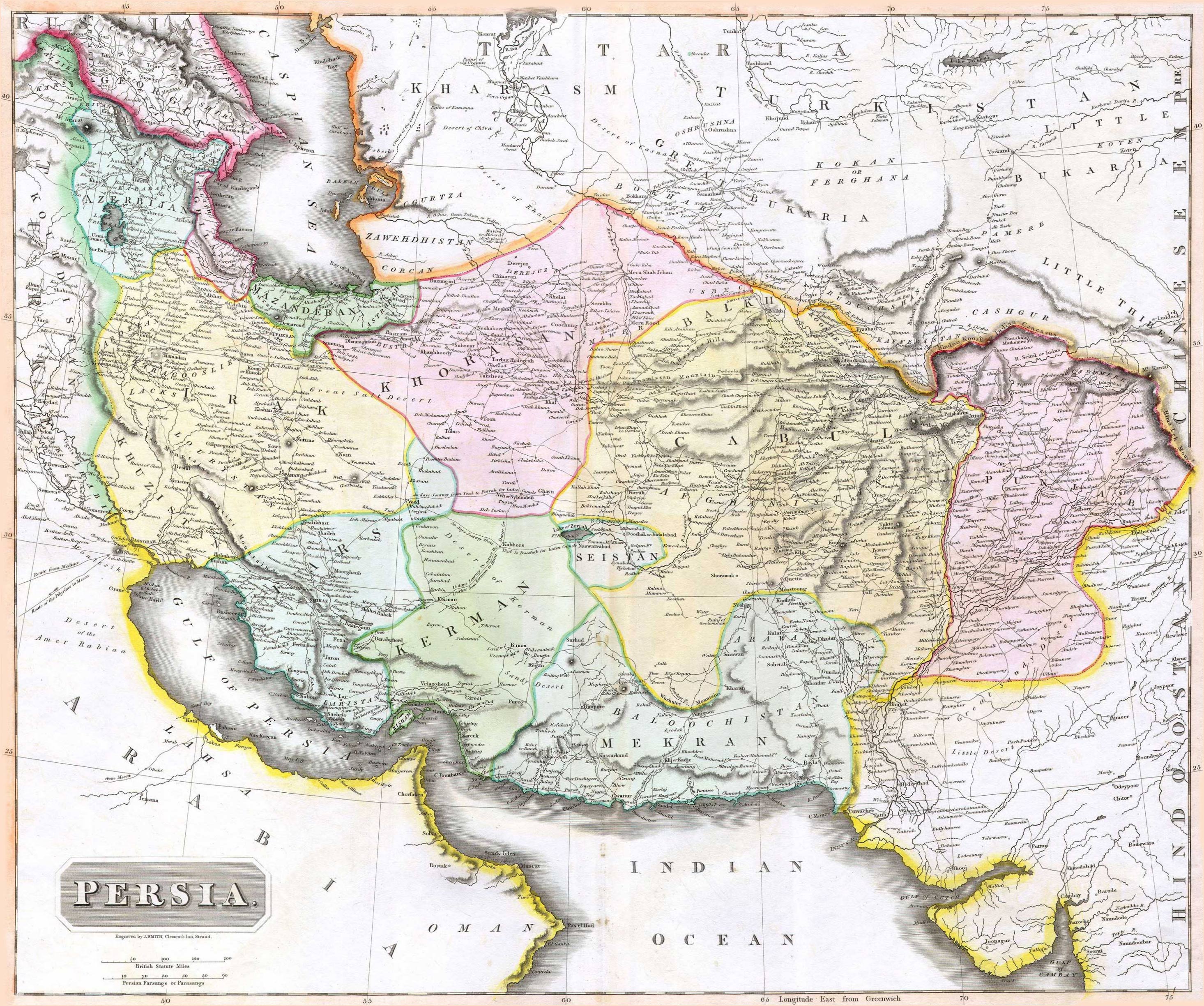
English: 1814 Thomson Map of Persia (Iran), engraved by J. Smith, Clement's Inn, Strand. |
| তারিখ | |
| স্রষ্টা |
J. Smith, Clement's Inn, Strand. |
| Geotemporal data | |
| মানচিত্রের অবস্থান | Iran |
| Warper-এ মানচিত্রের আস্তরণ | If inappropriate please set warp_status = skip to hide. |
| Bibliographic data | |
| প্রকাশনা |
New General Atlas (1821) |
| লেখক |
John Thomson |
| অন্যান্য সংস্করণ | |

লাইসেন্স প্রদান
The copyright situation of this work is theoretically uncertain, because in the country of origin copyright lasts 70 years after the death of the author, and the date of the author's death is unknown. However, the date of creation of the work was over 120 years ago, and it is thus a reasonable assumption that the copyright has expired (see here for the community discussion). Do not use this template if the date of death of the author is known.
এই কাজটি মার্কিন যুক্তরাষ্ট্রে পাবলিক ডোমেইনে রয়েছে কারণ এটি ১ জানুয়ারি, ১৯২৯ সালের আগে প্রকাশিত (অথবা মার্কিন কপিরাইট অফিসে নিবন্ধিত) হয়েছিল। | |
| এই ফাইলটি কপিরাইট আইনের আওতায় জানা সকল বাধানিষেধ মুক্ত বলে চিহ্নিত হয়েছে, যার মধ্যে সম্পর্কিত সকল স্বত্ব ও নেইবারিং সত্ত্ব সংযুক্ত। | |
ফাইলের ইতিহাস
যেকোনো তারিখ/সময়ে ক্লিক করে দেখুন ফাইলটি তখন কী অবস্থায় ছিল।
| তারিখ/সময় | সংক্ষেপচিত্র | মাত্রা | ব্যবহারকারী | মন্তব্য | |
|---|---|---|---|---|---|
| বর্তমান | ০৭:২৭, ১৮ আগস্ট ২০১০ | | ২,৯৩১ × ২,৪৪৮ (১.৬ মেগাবাইট) | Begoon | edge perspective and crop |
| ০২:৩৫, ১৯ নভেম্বর ২০০৬ |  | ২,৯৭৯ × ২,৫২০ (১.৪৫ মেগাবাইট) | Kaveh | == Summary == 1814 Thomson Map of Persia (Iran) Category:Maps of Iran == Licensing == {{PD-old}} |
সংযোগসমূহ
নিচের পৃষ্ঠা(গুলো) থেকে এই ছবিতে সংযোগ আছে:
ফাইলের বৈশ্বিক ব্যবহার
নিচের অন্যান্য উইকিগুলো এই ফাইলটি ব্যবহার করে:
- ar.wikipedia.org-এ ব্যবহার
- az.wikipedia.org-এ ব্যবহার
- be.wikipedia.org-এ ব্যবহার
- bs.wikipedia.org-এ ব্যবহার
- ca.wikipedia.org-এ ব্যবহার
- da.wikipedia.org-এ ব্যবহার
- de.wikipedia.org-এ ব্যবহার
- en.wikipedia.org-এ ব্যবহার
- es.wikipedia.org-এ ব্যবহার
- eu.wikipedia.org-এ ব্যবহার
- fa.wikipedia.org-এ ব্যবহার
- fr.wikipedia.org-এ ব্যবহার
- hi.wikipedia.org-এ ব্যবহার
- hr.wikipedia.org-এ ব্যবহার
এই ফাইলের অন্যান্য বৈশ্বিক ব্যবহার দেখুন।