
চিত্র:Mississippi-Alabama barrier islands.png

এই প্রাকদর্শনের আকার: ৮০০ × ২৯৭ পিক্সেল। অন্যান্য আকারসমূহ: ৩২০ × ১১৯ পিক্সেল | ৬৪০ × ২৩৮ পিক্সেল | ১,৬৭৭ × ৬২৩ পিক্সেল।
পূর্ণ রেজোলিউশন (১,৬৭৭ × ৬২৩ পিক্সেল, ফাইলের আকার: ২৬২ কিলোবাইট, এমআইএমই ধরন: image/png)
| এই ফাইলটি উইকিমিডিয়া কমন্স থেকে নেওয়া। সেখানের বর্ণনা পাতার বিস্তারিত নিম্নে দেখানো হলো। (সম্পাদনা)
|
সারাংশ
| বিবরণ |
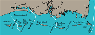
English: Locations of the Mississippi-Alabama barrier islands and associated tidal inlets. Deep draft shipping channels maintained by periodic dredging are shown as white lines. |
| তারিখ | |
| উৎস | Morton, Robert A.. Historical Changes in the Mississippi–Alabama Barrier Islands and the Roles of Extreme Storms, Sea Level, and Human Activities. USGS Publications Warehouse. United States Geological Survey. Retrieved on October 8, 2020. |
| লেখক |
Robert A. Morton U.S. Geological Survey |
লাইসেন্স প্রদান
এই কাজটি মার্কিন যুক্তরাষ্ট্রের পাবলিক ডোমেইনের অন্তর্গত কারণ মার্কিন যুক্তরাষ্ট্রের কোডের শিরোনাম ১৭, পরিচ্ছদ ১, অনুচ্ছেদ ১০৫ শর্তাবলীর অধীনে এটি একটি কাজ যা অফিসিয়াল দায়িত্বের অংশ হিসেবে মার্কিন যুক্তরাষ্ট্র সরকারের কর্মকর্তা বা কর্মচারী দ্বারা প্রস্তুতকৃত । বিস্তারিত জানতে দেখুন কপিরাইট।
টীকা: This only applies to original works of the Federal Government and not to the work of any individual U.S. state, territory, commonwealth, county, municipality, or any other subdivision. This template also does not apply to postage stamp designs published by the United States Postal Service since 1978. (মার্কিন যুক্তরাষ্ট্রে কপিরাইট অফিস চর্চার সারমর্মের § ৩১৩.৬(সি)(১) দেখুন)। এছাড়াও এটি নির্দিষ্ট কয়েকটি মার্কিন ধাতব মুদ্রার জন্য প্রযোজ্য নয়; মার্কিন টাকশালের ব্যবহারের শর্তাবলী দেখুন।
|
 | |
| এই ফাইলটি কপিরাইট আইনের আওতায় জানা সকল বাধানিষেধ মুক্ত বলে চিহ্নিত হয়েছে, যার মধ্যে সম্পর্কিত সকল স্বত্ব ও নেইবারিং সত্ত্ব সংযুক্ত। | ||
ফাইলের ইতিহাস
যেকোনো তারিখ/সময়ে ক্লিক করে দেখুন ফাইলটি তখন কী অবস্থায় ছিল।
| তারিখ/সময় | সংক্ষেপচিত্র | মাত্রা | ব্যবহারকারী | মন্তব্য | |
|---|---|---|---|---|---|
| বর্তমান | ০৪:১৯, ৮ অক্টোবর ২০২০ | ১,৬৭৭ × ৬২৩ (২৬২ কিলোবাইট) | Bryanrutherford0 | Uploaded a work by Robert A. Morton U.S. Geological Survey from https://pubs.usgs.gov/of/2007/1161/OFR-2007-1161-screen.pdf with UploadWizard |
সংযোগসমূহ
নিচের পৃষ্ঠা(গুলো) থেকে এই ছবিতে সংযোগ আছে:
ফাইলের বৈশ্বিক ব্যবহার
নিচের অন্যান্য উইকিগুলো এই ফাইলটি ব্যবহার করে:
- en.wikipedia.org-এ ব্যবহার
- fr.wikipedia.org-এ ব্যবহার
- www.wikidata.org-এ ব্যবহার