
চিত্র:LocatieRotterdam-2010.png
এর চেয়ে বেশি রেজোলিউশন লভ্য নয়।
LocatieRotterdam-2010.png (২৮০ × ১৩০ পিক্সেল, ফাইলের আকার: ৬ কিলোবাইট, এমআইএমই ধরন: image/png)
| এই ফাইলটি উইকিমিডিয়া কমন্স থেকে নেওয়া। সেখানের বর্ণনা পাতার বিস্তারিত নিম্নে দেখানো হলো। (সম্পাদনা)
|

|
This locator map image could be re-created using vector graphics as an SVG file. This has several advantages; see Commons:Media for cleanup for more information. If an SVG form of this image is available, please upload it and afterwards replace this template with
{{vector version available|new image name}}.
It is recommended to name the SVG file “LocatieRotterdam-2010.svg”—then the template Vector version available (or Vva) does not need the new image name parameter. |
সারাংশ
| বিবরণ |
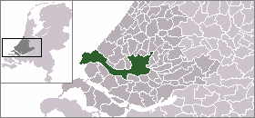
English: Map of Rotterdam: update for 2010 boundary change (addition of Rozenburg) |
| তারিখ | (UTC) |
| উৎস | |
| লেখক |
|
লাইসেন্স প্রদান
| আমি, এই কাজের স্বত্বাধিকারী, এতদ্দ্বারা আমি এই কাজকে পাবলিক ডোমেইন লাইসেন্সের আওতায় প্রকাশ করলাম। এটি বিশ্বব্যাপী প্রযোজ্য হবে। কিছু দেশে এটি আইনত সিদ্ধ নাও হতে পারে, যদি তাই হয়: আমি যে-কাউকে এই কাজটি যেকোনো উদ্দেশ্যে, বিনাশর্তে ব্যবহারের অনুমতি প্রদান করছি, যদি না সেই শর্তগুলো আইনত প্রয়োজনীয় হয়। |
মূল আপলোড লগ
This image is a derivative work of the following images:
- File:LocatieRotterdam.png licensed with PD-user
- 2005-06-19T00:24:29Z Andrew pmk 280x130 (5877 Bytes) pngcrush
- 2004-09-10T09:43:47Z Quistnix 280x130 (10042 Bytes) Location of Rotterdam in the Netherlands - by [[:nl:Gebruiker:Mtcv]]
ফাইলের ইতিহাস
যেকোনো তারিখ/সময়ে ক্লিক করে দেখুন ফাইলটি তখন কী অবস্থায় ছিল।
| তারিখ/সময় | সংক্ষেপচিত্র | মাত্রা | ব্যবহারকারী | মন্তব্য | |
|---|---|---|---|---|---|
| বর্তমান | ২৩:১৬, ২২ এপ্রিল ২০১০ | | ২৮০ × ১৩০ (৬ কিলোবাইট) | P199 | {{Information |Description={{en|Map of Rotterdam: update for 2010 boundary change (addition of Rozenburg)}} |Source=*File:LocatieRotterdam.png |Date=2010-04-22 23:13 (UTC) |Author=*File:LocatieRotterdam.png: '''Mtcv''' *derivativ |
সংযোগসমূহ
নিচের পৃষ্ঠা(গুলো) থেকে এই ছবিতে সংযোগ আছে:
ফাইলের বৈশ্বিক ব্যবহার
নিচের অন্যান্য উইকিগুলো এই ফাইলটি ব্যবহার করে:
- af.wikipedia.org-এ ব্যবহার
- als.wikipedia.org-এ ব্যবহার
- arz.wikipedia.org-এ ব্যবহার
- ban.wikipedia.org-এ ব্যবহার
- de.wikipedia.org-এ ব্যবহার
- en.wikipedia.org-এ ব্যবহার
- fj.wikipedia.org-এ ব্যবহার
- fr.wikipedia.org-এ ব্যবহার
- id.wikipedia.org-এ ব্যবহার
- is.wikipedia.org-এ ব্যবহার
- li.wikipedia.org-এ ব্যবহার
- mai.wikipedia.org-এ ব্যবহার
- mk.wikipedia.org-এ ব্যবহার
- mn.wikipedia.org-এ ব্যবহার
- nl.wikipedia.org-এ ব্যবহার
- sco.wikipedia.org-এ ব্যবহার
- sq.wikipedia.org-এ ব্যবহার
- th.wikipedia.org-এ ব্যবহার
- tr.wikipedia.org-এ ব্যবহার
- uk.wikipedia.org-এ ব্যবহার
- ur.wikipedia.org-এ ব্যবহার
- zh-min-nan.wikipedia.org-এ ব্যবহার
- zh.wikipedia.org-এ ব্যবহার
- zu.wikipedia.org-এ ব্যবহার