
চিত্র:Ice-floe params hg.png

এই প্রাকদর্শনের আকার: ৮০০ × ৩৯২ পিক্সেল। অন্যান্য আকারসমূহ: ৩২০ × ১৫৭ পিক্সেল | ৬৪০ × ৩১৪ পিক্সেল | ১,০২৪ × ৫০২ পিক্সেল | ১,২৮০ × ৬২৮ পিক্সেল | ২,৮০০ × ১,৩৭৩ পিক্সেল।
পূর্ণ রেজোলিউশন (২,৮০০ × ১,৩৭৩ পিক্সেল, ফাইলের আকার: ১১৫ কিলোবাইট, এমআইএমই ধরন: image/png)
| এই ফাইলটি উইকিমিডিয়া কমন্স থেকে নেওয়া। সেখানের বর্ণনা পাতার বিস্তারিত নিম্নে দেখানো হলো। (সম্পাদনা)
|
| বিবরণ |
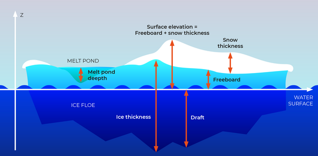
English: Section through an ice floe with parameters used in glaciological research to quantify and describe the coverage of sea ice
Русский: Сечение льдины и её параетры, используемые в гляциологии для описания и количественных оценок покрытия морей льдом.
|
| তারিখ | |
| উৎস | own work, redrawn from a draft by Valerij Cysko under the supervision of Dr. Christian Haas, geophysicist at Alfred Wegener Institute for Polar and Marine Research, Bremerhaven |
| লেখক | Amanda Grobe & Hannes Grobe 21:53, 12 August 2006 (UTC), Alfred Wegener Institute for Polar and Marine Research, Bremerhaven, Germany |
| অনুমতি (এ ফাইলের পুনঃব্যবহার) |
own work, share alike, attribution required (Creative Commons CC-BY-SA-2.5) |
| অন্যান্য সংস্করণ | original grafic in Intaglio format available from the author |
আমি, এই কাজের স্বত্বাধিকারী, এতদ্দ্বারা আমি এই কাজকে নিম্ন বর্ণিত লাইসেন্সের আওতায় প্রকাশ করলাম:
এই ফাইলটি ক্রিয়েটিভ কমন্স অ্যাট্রিবিউশন-শেয়ার অ্যালাইক ২.৫ জেনেরিক লাইসেন্সের আওতায় লাইসেন্সকৃত।
- আপনি স্বাধীনভাবে:
- বণ্টন করতে পারেন – এ কাজটি অনুলিপি, বিতরণ এবং প্রেরণ করতে পারেন
- পুনঃমিশ্রণ করতে পারেন – কাজটি অভিযোজন করতে পারেন
- নিম্নের শর্তাবলীর ভিত্তিতে:
- স্বীকৃতিপ্রদান – আপনাকে অবশ্যই যথাযথ স্বীকৃতি প্রদান করতে হবে, লাইসেন্সের একটি লিঙ্ক সরবরাহ করতে হবে এবং কোনো পরিবর্তন হয়েছে কিনা তা নির্দেশ করতে হবে। আপনি যেকোনো যুক্তিসঙ্গত পদ্ধতিতে এটি করতে পারেন। কিন্তু এমন ভাবে নয়, যাতে প্রকাশ পায় যে লাইসেন্সধারী আপনাকে বা আপনার এই ব্যবহারের জন্য অনুমোদন দিয়েছে।
- একইভাবে বণ্টন – আপনি যদি কাজটি পুনঃমিশ্রণ, রুপান্তর, বা এর ওপর ভিত্তি করে নতুন সৃষ্টিকর্ম তৈরি করেন, তবে আপনাকে অবশ্যই আপনার অবদান একই লাইসেন্স বা একই রকমের লাইসেন্সের আওতায় বিতরণ করতে হবে।

|
This geology image could be re-created using vector graphics as an SVG file. This has several advantages; see Commons:Media for cleanup for more information. If an SVG form of this image is available, please upload it and afterwards replace this template with
{{vector version available|new image name}}.
It is recommended to name the SVG file “Ice-floe params hg.svg”—then the template Vector version available (or Vva) does not need the new image name parameter. |
ফাইলের ইতিহাস
যেকোনো তারিখ/সময়ে ক্লিক করে দেখুন ফাইলটি তখন কী অবস্থায় ছিল।
| তারিখ/সময় | সংক্ষেপচিত্র | মাত্রা | ব্যবহারকারী | মন্তব্য | |
|---|---|---|---|---|---|
| বর্তমান | ২১:২৯, ২৪ সেপ্টেম্বর ২০২৩ | | ২,৮০০ × ১,৩৭৩ (১১৫ কিলোবাইট) | Beao | Cropped 13 % vertically using CropTool with lossless mode. Removed watermark. |
| ২৩:১০, ২০ এপ্রিল ২০২২ |  | ২,৮০০ × ১,৫৭৬ (১৩০ কিলোবাইট) | RASPBERRY VIBE | Image resolution increase, data structuring. | |
| ০৪:৪২, ২১ আগস্ট ২০০৬ |  | ৬৭৫ × ৩৭৬ (১৫৭ কিলোবাইট) | Hgrobe | {{Information| |Description=Section through an ice floe with parameters used in glaciological research to quantify and describe the coverage of sea ice * '''Ice thickness''': total thickness of the ice floe (draft + freeboard) * '''Freeboard''': part of t | |
| ০৪:৩৪, ২১ আগস্ট ২০০৬ |  | ৭৮৩ × ৫৫৯ (১৬৩ কিলোবাইট) | Hgrobe | {{Information| |Description=Section through an ice floe with parameters used in glaciological research to quantify and describe the coverage of sea ice * '''Ice thickness''': total thickness of the ice floe (draft + freeboard) * '''Freeboard''': part of t | |
| ২১:৫৩, ১২ আগস্ট ২০০৬ |  | ১,০০৬ × ৫৫৭ (২৬১ কিলোবাইট) | Hgrobe | {{Information| |Description=Section through an ice floe with parameters used in glaciological research to quantify and describe the coverage of sea ice |Source=own work |Date=2006-08-08 |Author=~~~~ |Permission=Own work, share alike, attribution required |
সংযোগসমূহ
নিচের পৃষ্ঠা(গুলো) থেকে এই ছবিতে সংযোগ আছে:
ফাইলের বৈশ্বিক ব্যবহার
নিচের অন্যান্য উইকিগুলো এই ফাইলটি ব্যবহার করে:
- be.wikipedia.org-এ ব্যবহার
- ca.wikipedia.org-এ ব্যবহার
- cv.wikipedia.org-এ ব্যবহার
- de.wikipedia.org-এ ব্যবহার
- el.wikipedia.org-এ ব্যবহার
- en.wikipedia.org-এ ব্যবহার
- en.wiktionary.org-এ ব্যবহার
- es.wikipedia.org-এ ব্যবহার
- it.wikipedia.org-এ ব্যবহার
- ja.wikipedia.org-এ ব্যবহার
- ko.wikipedia.org-এ ব্যবহার
- mnw.wiktionary.org-এ ব্যবহার
- nl.wikipedia.org-এ ব্যবহার
- nn.wikipedia.org-এ ব্যবহার
- no.wikipedia.org-এ ব্যবহার
- simple.wikipedia.org-এ ব্যবহার
- uk.wikipedia.org-এ ব্যবহার
- zh.wikipedia.org-এ ব্যবহার
- zh.wiktionary.org-এ ব্যবহার