
চিত্র:Easter island and south america.jpg

এর চেয়ে বেশি রেজোলিউশন লভ্য নয়।
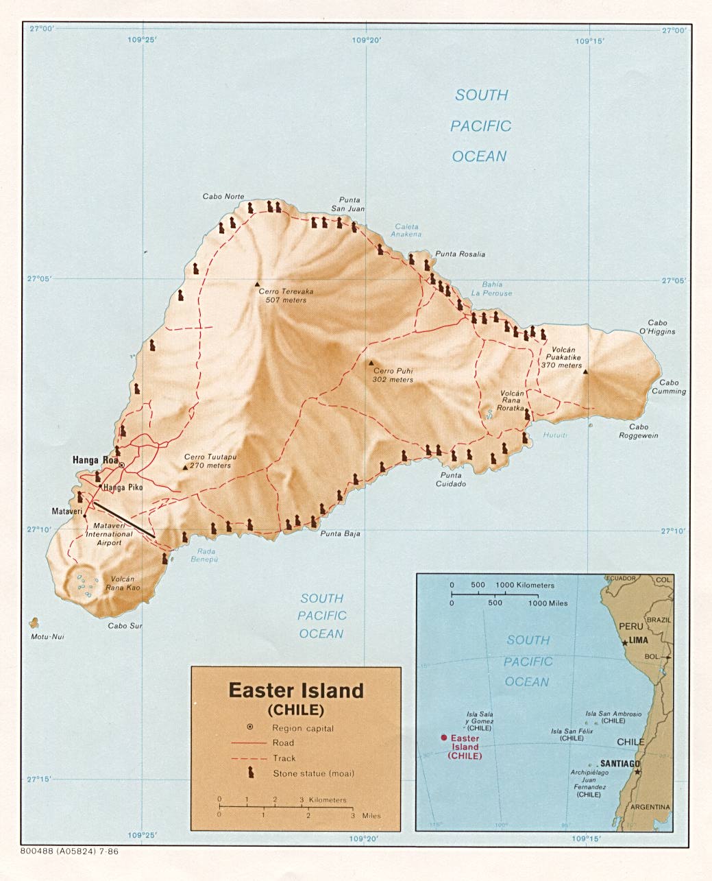
Easter_island_and_south_america.jpg (৩৪৫ × ৩৪৫ পিক্সেল, ফাইলের আকার: ৭৮ কিলোবাইট, এমআইএমই ধরন: image/jpeg)
| এই ফাইলটি উইকিমিডিয়া কমন্স থেকে নেওয়া। সেখানের বর্ণনা পাতার বিস্তারিত নিম্নে দেখানো হলো। (সম্পাদনা)
|
সারাংশ
| বিবরণ | |||
| তারিখ | |||
| উৎস | From http://www.lib.utexas.edu/maps/islands_oceans_poles/easterisland.jpg | ||
| লেখক | CIA | ||
| অনুমতি (এ ফাইলের পুনঃব্যবহার) |
http://www.lib.utexas.edu/usage_statement.html. ClockworkTroll 22:16, 3 Oct 2004 (UTC) "Used by permission of The General Libraries, The University of Texas at Austin." |
||
| অন্যান্য সংস্করণ |

|


লাইসেন্স প্রদান
| এই চিত্রটি সেন্ট্রাল ইন্টেলিজেন্স এজেন্সির একজন কর্মীর কর্ম, যা তিনি তার অফিশিয়াল কর্তব্যের অংশ হিসেবে সৃষ্টি করেছেন বা তুলেছেন। মার্কিন যুক্তরাষ্ট্র সরকারের একটি কর্ম হিসেবে, এই চিত্র বা মিডিয়াটি মার্কিন যুক্তরাষ্ট্রে পাবলিক ডোমেইনভুক্ত।
|

|
মূল আপলোড লগ
All following user names refer to en.wikipedia.
- 2003-08-13 11:58 Pascal 345×345× (80378 bytes) Easter Island and its location in South America from http://www.lib.utexas.edu/maps/islands_oceans_poles/easterisland.jpg
ফাইলের ইতিহাস
যেকোনো তারিখ/সময়ে ক্লিক করে দেখুন ফাইলটি তখন কী অবস্থায় ছিল।
| তারিখ/সময় | সংক্ষেপচিত্র | মাত্রা | ব্যবহারকারী | মন্তব্য | |
|---|---|---|---|---|---|
| বর্তমান | ১৯:৪৮, ২৫ এপ্রিল ২০০৯ | | ৩৪৫ × ৩৪৫ (৭৮ কিলোবাইট) | File Upload Bot (Magnus Manske) | {{BotMoveToCommons|en.wikipedia|year={{subst:CURRENTYEAR}}|month={{subst:CURRENTMONTHNAME}}|day={{subst:CURRENTDAY}}}} {{Information |Description={{en|en:Easter Island and the islands between it and en:South America. From http://www.lib.utexa |
সংযোগসমূহ
নিচের পৃষ্ঠা(গুলো) থেকে এই ছবিতে সংযোগ আছে:
ফাইলের বৈশ্বিক ব্যবহার
নিচের অন্যান্য উইকিগুলো এই ফাইলটি ব্যবহার করে:
- ace.wikipedia.org-এ ব্যবহার
- ar.wikipedia.org-এ ব্যবহার
- cy.wikipedia.org-এ ব্যবহার
- en.wikipedia.org-এ ব্যবহার
- fa.wikipedia.org-এ ব্যবহার
- fr.wikipedia.org-এ ব্যবহার
- he.wikipedia.org-এ ব্যবহার
- hi.wikipedia.org-এ ব্যবহার
- hr.wikipedia.org-এ ব্যবহার
- id.wikipedia.org-এ ব্যবহার
- ml.wikipedia.org-এ ব্যবহার
- pih.wikipedia.org-এ ব্যবহার
- ro.wikipedia.org-এ ব্যবহার
- rw.wikipedia.org-এ ব্যবহার
- sl.wikipedia.org-এ ব্যবহার
- ta.wikipedia.org-এ ব্যবহার
- ta.wikinews.org-এ ব্যবহার
- te.wikipedia.org-এ ব্যবহার
- vi.wikipedia.org-এ ব্যবহার
- xmf.wikipedia.org-এ ব্যবহার
- yo.wikipedia.org-এ ব্যবহার
- zh.wikipedia.org-এ ব্যবহার