
চিত্র:Brittain 410.jpg
পূর্ণ রেজোলিউশন (১,১১১ × ১,৪৯৭ পিক্সেল, ফাইলের আকার: ৩৬৯ কিলোবাইট, এমআইএমই ধরন: image/jpeg)
| এই ফাইলটি উইকিমিডিয়া কমন্স থেকে নেওয়া। সেখানের বর্ণনা পাতার বিস্তারিত নিম্নে দেখানো হলো। (সম্পাদনা)
|
সারাংশ
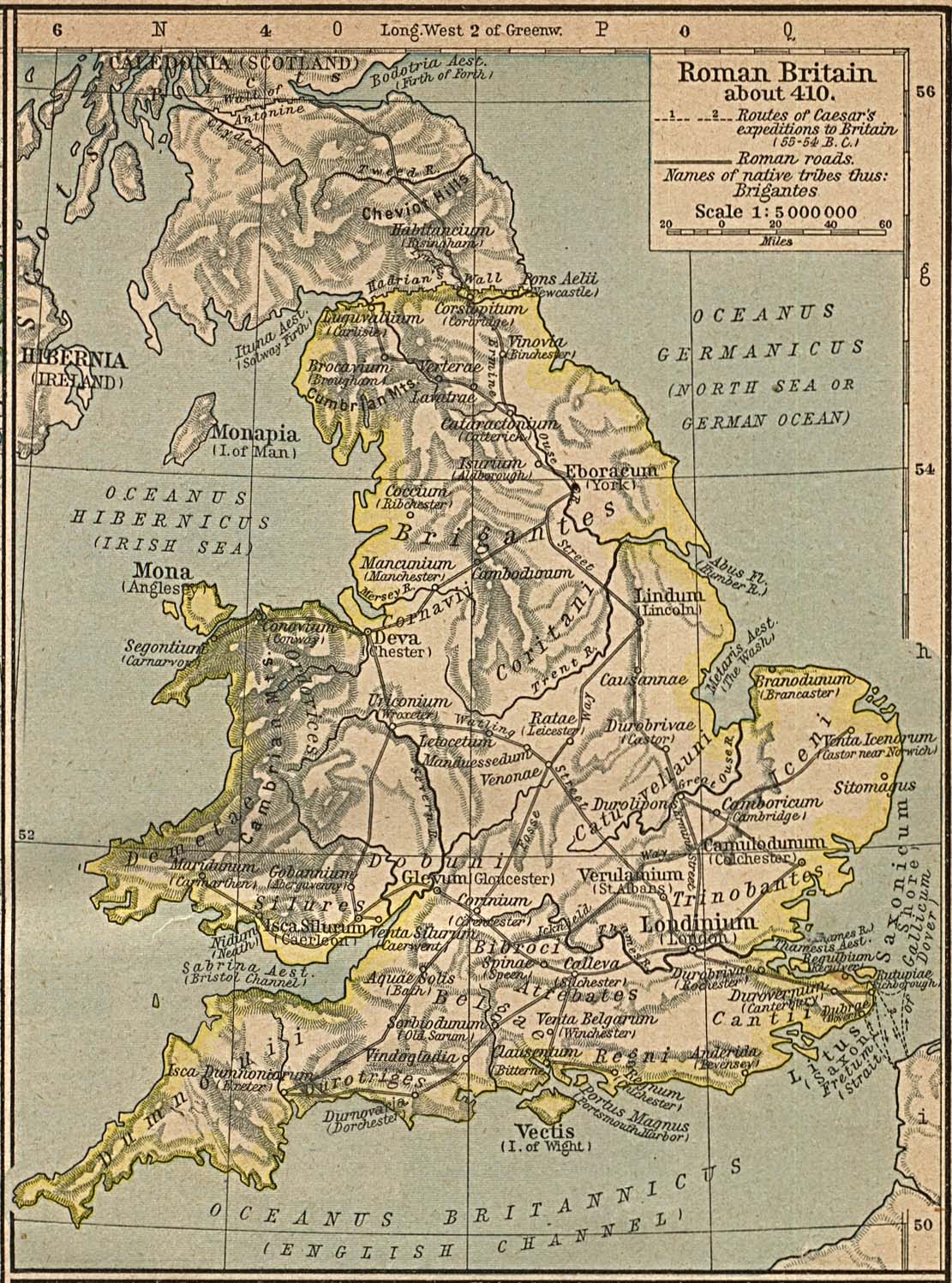
Map of the isle Great Britain in the year 410. Image comes from the Historical Maps of Europe at University of Texas at Austin The work is from From The Historical Atlas by William R. Shepherd, 1926.
Map is released into the public Domain.
লাইসেন্স প্রদান
|
এই কর্মটি এর উৎস দেশে পাবলিক ডোমেইনে রয়েছে এবং অন্যান্য দেশ ও অঞ্চলে যেখানে কপিরাটের সময়সীমা হচ্ছে লেখকের জীবন যোগ ৭০ বছর বা তাঁর কম।
| |
| এই ফাইলটি কপিরাইট আইনের আওতায় জানা সকল বাধানিষেধ মুক্ত বলে চিহ্নিত হয়েছে, যার মধ্যে সম্পর্কিত সকল স্বত্ব ও নেইবারিং সত্ত্ব সংযুক্ত। | |
ফাইলের ইতিহাস
যেকোনো তারিখ/সময়ে ক্লিক করে দেখুন ফাইলটি তখন কী অবস্থায় ছিল।
| তারিখ/সময় | সংক্ষেপচিত্র | মাত্রা | ব্যবহারকারী | মন্তব্য | |
|---|---|---|---|---|---|
| বর্তমান | ১৫:২৪, ৩ ডিসেম্বর ২০০৫ | | ১,১১১ × ১,৪৯৭ (৩৬৯ কিলোবাইট) | Migdejong | Map of the isle Great Brittain in the year 410. Image comes from the University of Texas at Austin: http://geography.about.com/gi/dynamic/offsite.htm?site=http://www.lib.utexas.edu/maps/historical/history%5Feurope.html Map is released into the publi |
সংযোগসমূহ
নিচের পৃষ্ঠা(গুলো) থেকে এই ছবিতে সংযোগ আছে:
ফাইলের বৈশ্বিক ব্যবহার
নিচের অন্যান্য উইকিগুলো এই ফাইলটি ব্যবহার করে:
- ar.wikipedia.org-এ ব্যবহার
- arz.wikipedia.org-এ ব্যবহার
- azb.wikipedia.org-এ ব্যবহার
- br.wikipedia.org-এ ব্যবহার
- ca.wikipedia.org-এ ব্যবহার
- cy.wikipedia.org-এ ব্যবহার
- el.wikipedia.org-এ ব্যবহার
- en.wikipedia.org-এ ব্যবহার
- es.wikipedia.org-এ ব্যবহার
- et.wikipedia.org-এ ব্যবহার
- fr.wikipedia.org-এ ব্যবহার
- hr.wikipedia.org-এ ব্যবহার
- hu.wikipedia.org-এ ব্যবহার
- hy.wikipedia.org-এ ব্যবহার
- is.wikipedia.org-এ ব্যবহার
- it.wikipedia.org-এ ব্যবহার
- lt.wikipedia.org-এ ব্যবহার
- pl.wikipedia.org-এ ব্যবহার
- ru.wikipedia.org-এ ব্যবহার
- sh.wikipedia.org-এ ব্যবহার
- sl.wikipedia.org-এ ব্যবহার
- sr.wikipedia.org-এ ব্যবহার
- zh.wikipedia.org-এ ব্যবহার