
চিত্র:Bengal map 1893.JPG
পূর্ণ রেজোলিউশন (১,০৬৩ × ১,৩২৭ পিক্সেল, ফাইলের আকার: ৩৯৬ কিলোবাইট, এমআইএমই ধরন: image/jpeg)
| এই ফাইলটি উইকিমিডিয়া কমন্স থেকে নেওয়া। সেখানের বর্ণনা পাতার বিস্তারিত নিম্নে দেখানো হলো। (সম্পাদনা)
|
সারাংশ
| বর্ণনা |
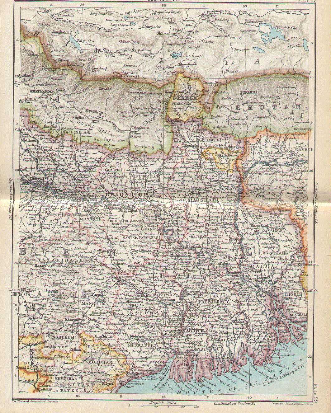
English: 1893 map of Bengal |
|||||||||
| তারিখ | ||||||||||
| উৎস | Here | |||||||||
| স্রষ্টা |
John Bartholomew |
|||||||||
| অনুমতি (এ ফাইলের পুনঃব্যবহার) |
This image is in the public domain due to its age. | |||||||||
| Geotemporal data | ||||||||||
| ভৌগলিক সীমা |
|
|||||||||
| Warper-এ মানচিত্রের আস্তরণ | ||||||||||
লাইসেন্স প্রদান
|
এই কর্মটি এর উৎস দেশে পাবলিক ডোমেইনে রয়েছে এবং অন্যান্য দেশ ও অঞ্চলে যেখানে কপিরাটের সময়সীমা হচ্ছে লেখকের জীবন যোগ ৭০ বছর বা তাঁর কম।
| |
| এই ফাইলটি কপিরাইট আইনের আওতায় জানা সকল বাধানিষেধ মুক্ত বলে চিহ্নিত হয়েছে, যার মধ্যে সম্পর্কিত সকল স্বত্ব ও নেইবারিং সত্ত্ব সংযুক্ত। | |
|
এই কর্মটি এর উৎস দেশে পাবলিক ডোমেইনে রয়েছে এবং অন্যান্য দেশ ও অঞ্চলে যেখানে কপিরাটের সময়সীমা হচ্ছে লেখকের জীবন যোগ ১০০ বছর বা তাঁর কম। এই কাজটি মার্কিন যুক্তরাষ্ট্রে পাবলিক ডোমেইনে রয়েছে কারণ এটি ১ জানুয়ারি, ১৯২৯ সালের আগে প্রকাশিত (অথবা মার্কিন কপিরাইট অফিসে নিবন্ধিত) হয়েছিল। | |
| এই ফাইলটি কপিরাইট আইনের আওতায় জানা সকল বাধানিষেধ মুক্ত বলে চিহ্নিত হয়েছে, যার মধ্যে সম্পর্কিত সকল স্বত্ব ও নেইবারিং সত্ত্ব সংযুক্ত। | |
| Annotations | This image is annotated: View the annotations at Commons |
ফাইলের ইতিহাস
যেকোনো তারিখ/সময়ে ক্লিক করে দেখুন ফাইলটি তখন কী অবস্থায় ছিল।
| তারিখ/সময় | সংক্ষেপচিত্র | মাত্রা | ব্যবহারকারী | মন্তব্য | |
|---|---|---|---|---|---|
| বর্তমান | ০৩:৫৪, ১১ এপ্রিল ২০০৬ | | ১,০৬৩ × ১,৩২৭ (৩৯৬ কিলোবাইট) | Roke~commonswiki | map from [http://homepages.rootsweb.com/~poyntz/India/maps.html] {{PD-old}} Category: Bengal |
সংযোগসমূহ
এই ফাইল ব্যবহার করে এমন কোনো পাতা নেই।
ফাইলের বৈশ্বিক ব্যবহার
নিচের অন্যান্য উইকিগুলো এই ফাইলটি ব্যবহার করে:
- be.wikipedia.org-এ ব্যবহার
- en.wikipedia.org-এ ব্যবহার
- fi.wikipedia.org-এ ব্যবহার
- incubator.wikimedia.org-এ ব্যবহার
- it.wikipedia.org-এ ব্যবহার
- kn.wikipedia.org-এ ব্যবহার
- pnb.wikipedia.org-এ ব্যবহার
- ru.wikipedia.org-এ ব্যবহার
- sq.wikipedia.org-এ ব্যবহার
- ta.wikipedia.org-এ ব্যবহার
- uk.wikipedia.org-এ ব্যবহার
- ur.wikipedia.org-এ ব্যবহার