
চিত্র:Barrier north Jerusalem.jpg
এই প্রাকদর্শনের আকার: ৫৮২ × ৬০০ পিক্সেল। অন্যান্য আকারসমূহ: ২৩৩ × ২৪০ পিক্সেল | ৪৬৬ × ৪৮০ পিক্সেল | ৮০৯ × ৮৩৪ পিক্সেল।
পূর্ণ রেজোলিউশন (৮০৯ × ৮৩৪ পিক্সেল, ফাইলের আকার: ৩৬২ কিলোবাইট, এমআইএমই ধরন: image/jpeg)
| এই ফাইলটি উইকিমিডিয়া কমন্স থেকে নেওয়া। সেখানের বর্ণনা পাতার বিস্তারিত নিম্নে দেখানো হলো। (সম্পাদনা)
|
সারাংশ
| বিবরণ |
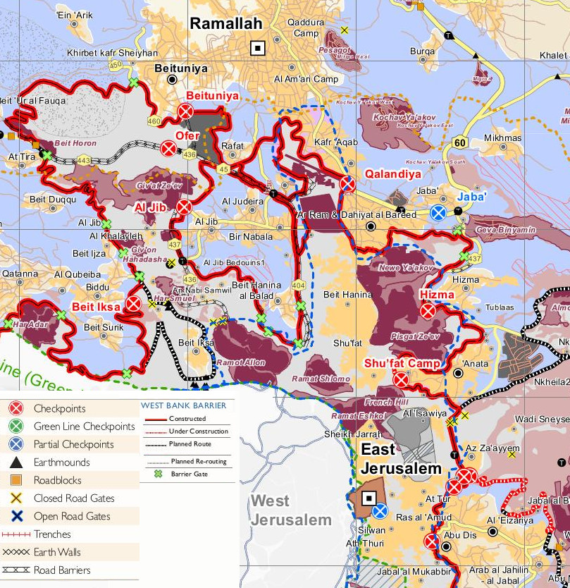
English: The Israeli barrier in northern Jerusalem beyond the "Green Line", separating Palestinian land in East Jerusalem from the rest of the West Bank. Also separating the West Bank from Jerusalem. |
| তারিখ | |
| উৎস | নিজের কাজ. Derived from Humanitarian Atlas (file size 49 MB), OCHAoPt, December 2012, which is considered public domain. |
| লেখক | Wickey-nl |
লাইসেন্স প্রদান
আমি, এই কাজের স্বত্বাধিকারী, এতদ্দ্বারা আমি এই কাজকে নিম্ন বর্ণিত লাইসেন্সের আওতায় প্রকাশ করলাম:
এই ফাইলটি ক্রিয়েটিভ কমন্স অ্যাট্রিবিউশন ৩.০ আনপোর্টেড লাইসেন্সের আওতায় লাইসেন্সকৃত।
- আপনি স্বাধীনভাবে:
- বণ্টন করতে পারেন – এ কাজটি অনুলিপি, বিতরণ এবং প্রেরণ করতে পারেন
- পুনঃমিশ্রণ করতে পারেন – কাজটি অভিযোজন করতে পারেন
- নিম্নের শর্তাবলীর ভিত্তিতে:
- স্বীকৃতিপ্রদান – আপনাকে অবশ্যই যথাযথ স্বীকৃতি প্রদান করতে হবে, লাইসেন্সের একটি লিঙ্ক সরবরাহ করতে হবে এবং কোনো পরিবর্তন হয়েছে কিনা তা নির্দেশ করতে হবে। আপনি যেকোনো যুক্তিসঙ্গত পদ্ধতিতে এটি করতে পারেন। কিন্তু এমন ভাবে নয়, যাতে প্রকাশ পায় যে লাইসেন্সধারী আপনাকে বা আপনার এই ব্যবহারের জন্য অনুমোদন দিয়েছে।

ফাইলের ইতিহাস
যেকোনো তারিখ/সময়ে ক্লিক করে দেখুন ফাইলটি তখন কী অবস্থায় ছিল।
| তারিখ/সময় | সংক্ষেপচিত্র | মাত্রা | ব্যবহারকারী | মন্তব্য | |
|---|---|---|---|---|---|
| বর্তমান | ১৫:০২, ১৭ মার্চ ২০১৪ | | ৮০৯ × ৮৩৪ (৩৬২ কিলোবাইট) | Wickey-nl | User created page with UploadWizard |
সংযোগসমূহ
নিচের পৃষ্ঠা(গুলো) থেকে এই ছবিতে সংযোগ আছে:
ফাইলের বৈশ্বিক ব্যবহার
নিচের অন্যান্য উইকিগুলো এই ফাইলটি ব্যবহার করে:
- ar.wikipedia.org-এ ব্যবহার
- ca.wikipedia.org-এ ব্যবহার
- en.wikipedia.org-এ ব্যবহার
- he.wikipedia.org-এ ব্যবহার
- nl.wikipedia.org-এ ব্যবহার
- no.wikipedia.org-এ ব্যবহার