
চিত্র:1794 Anville Map of Ancient Egypt - Geographicus - Egypt-anville-1794.jpg

এই প্রাকদর্শনের আকার: ৪০০ × ৬০০ পিক্সেল। অন্যান্য আকারসমূহ: ১৬০ × ২৪০ পিক্সেল | ৩২০ × ৪৮০ পিক্সেল | ৫১২ × ৭৬৮ পিক্সেল | ৬৮৩ × ১,০২৪ পিক্সেল | ১,৩৬৬ × ২,০৪৮ পিক্সেল | ২,৬৬৮ × ৪,০০০ পিক্সেল।
পূর্ণ রেজোলিউশন (২,৬৬৮ × ৪,০০০ পিক্সেল, ফাইলের আকার: ২.৬৪ মেগাবাইট, এমআইএমই ধরন: image/jpeg)
| এই ফাইলটি উইকিমিডিয়া কমন্স থেকে নেওয়া। সেখানের বর্ণনা পাতার বিস্তারিত নিম্নে দেখানো হলো। (সম্পাদনা)
|
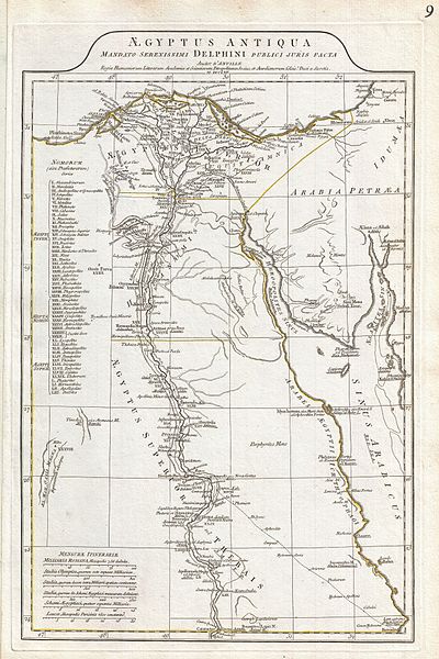
| Jean Baptiste Bourguignon d'Anville: Aegyptus Antiqua Mandato Serenissimi Delphini Publici Juris Facta.
( |
|||||||||||||||||||||
|---|---|---|---|---|---|---|---|---|---|---|---|---|---|---|---|---|---|---|---|---|---|
| শিল্পী |
|
||||||||||||||||||||
| শিরোনাম |
Aegyptus Antiqua Mandato Serenissimi Delphini Publici Juris Facta. |
||||||||||||||||||||
| বিবরণ |
English: A large and dramatic 1794 J. B. B. D'Anville map of Ancient Egypt Covers from the Nile Delta and Gaza south as far as Aswan. Details mountains, rivers, cities, roadways, and lakes with political divisions highlighted in outline color. Features both ancient and contemporary place names, ie. Thebae and Luxor, for each destination - an invaluable resource or scholars of antiquity. Identifies the Pyramids, Mount Sinai, Natron, Philae Island, the Cataracts, etc. Title area appears in a raised zone above the map proper. Includes six distance scales, bottom left, referencing various measurement systems common in antiquity. Text in Latin and English. Drawn by J. B. B. D'Anville in 1762 and published in 1794 by Laurie and Whittle, London. |
||||||||||||||||||||
| তারিখ | ১৭৯৪ (dated) | ||||||||||||||||||||
| আকার | উচ্চতা: ২০.০ ইঞ্চি (৫০.৮ সে.মি.); প্রস্থ: ১২.৫ ইঞ্চি (৩১.৭ সে.মি.) | ||||||||||||||||||||
| সংযোজন সংখ্যা |
Geographicus link: Egypt-anville-1794 |
||||||||||||||||||||
| উৎস/আলোকচিত্রগ্রাহক |
D'Anville, J. B. B., Complete Body of Ancient Geography, Laurie and Whittle, London, 1795.
|
||||||||||||||||||||
| অনুমতি (এ ফাইলের পুনঃব্যবহার) |
|
||||||||||||||||||||

ফাইলের ইতিহাস
যেকোনো তারিখ/সময়ে ক্লিক করে দেখুন ফাইলটি তখন কী অবস্থায় ছিল।
| তারিখ/সময় | সংক্ষেপচিত্র | মাত্রা | ব্যবহারকারী | মন্তব্য | |
|---|---|---|---|---|---|
| বর্তমান | ১৪:৪৯, ২৩ মার্চ ২০১১ | | ২,৬৬৮ × ৪,০০০ (২.৬৪ মেগাবাইট) | BotMultichillT | {{subst:User:Multichill/Geographicus |link=http://www.geographicus.com/P/AntiqueMap/Egypt-anville-1794 |product_name=1794 Anville Map of Ancient Egypt |map_title=Aegyptus Antiqua Mandato Serenissimi Delphini Publici Juris Facta. |description=A large and d |
সংযোগসমূহ
নিচের পৃষ্ঠা(গুলো) থেকে এই ছবিতে সংযোগ আছে:
ফাইলের বৈশ্বিক ব্যবহার
নিচের অন্যান্য উইকিগুলো এই ফাইলটি ব্যবহার করে:
- en.wikipedia.org-এ ব্যবহার
- id.wikipedia.org-এ ব্যবহার
- io.wikipedia.org-এ ব্যবহার
- ms.wikipedia.org-এ ব্যবহার
- ru.wikipedia.org-এ ব্যবহার
- sk.wikipedia.org-এ ব্যবহার
- ta.wikipedia.org-এ ব্যবহার
- xmf.wikipedia.org-এ ব্যবহার