আক্কাদীয় সাম্রাজ্য: সংশোধিত সংস্করণের মধ্যে পার্থক্য
বিষয়বস্তু বিয়োগ হয়েছে বিষয়বস্তু যোগ হয়েছে
Ashiq Shawon (আলোচনা | অবদান) নতুন নিবন্ধন |
(কোনও পার্থক্য নেই)
|
০৬:৪৪, ২৪ ডিসেম্বর ২০১৩ তারিখে সংশোধিত সংস্করণ
আক্কাদীয় সাম্রাজ্য | |
|---|---|
| খ্রিষ্টপূর্ব ২৩৩৪–খ্রিষ্টপূর্ব ২১৯৩ | |
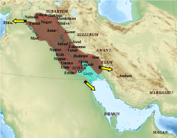
 Map of the Akkadian Empire (brown) and the directions in which military campaigns were conducted (yellow arrows) | |
| অবস্থা | সাম্রাজ্য |
| রাজধানী | Akkad |
| প্রচলিত ভাষা | Akkadian, Sumerian |
| ধর্ম | Sumerian religion |
| সরকার | সম্রাট |
| King | |
• 2334 BC | Sargon of Akkad |
| ঐতিহাসিক যুগ | প্রাচীন |
• প্রতিষ্ঠা | খ্রিষ্টপূর্ব ২৩৩৪ |
• বিলুপ্ত | খ্রিষ্টপূর্ব ২১৯৩ |
| আয়তন | |
| 2334 BC[১] | ৮,০০,০০০ বর্গকিলোমিটার (৩,১০,০০০ বর্গমাইল) |
| Iraq ইতিহাস |
|---|
| ধারাবাহিকের একটি অংশ |
 |
| Ancient Iraq |
| Classical Iraq |
| Medieval Iraq |
| 20th-century Iraq |
| Republic of Iraq |
- ↑ Taagepera, Rein (১৯৭৮)। "Size and duration of empires growth-decline curves, 3000 to 600 B.C."। Social Science Research। 7: 180–195। ডিওআই:10.1016/0049-089X(78)90010-8।
