ক্যানসাস সিটি, মিজুরি: সংশোধিত সংস্করণের মধ্যে পার্থক্য
বিষয়বস্তু বিয়োগ হয়েছে বিষয়বস্তু যোগ হয়েছে
অ বট নিবন্ধ পরিষ্কার করেছে |
অ টেমপ্লেটে সংশোধন |
||
| ৩০ নং লাইন: | ৩০ নং লাইন: | ||
|area_magnitude = 1 E8 |
|area_magnitude = 1 E8 |
||
|area_footnotes = <ref name="Gazetteer files">{{ |
|area_footnotes = <ref name="Gazetteer files">{{ওয়েব উদ্ধৃতি|title=US Gazetteer files 2010|url=http://www.census.gov/geo/www/gazetteer/files/Gaz_places_national.txt|publisher={{URL|1=http://en.wikipedia.org/wiki/United_States_Census_Bureau|2=United States Census Bureau}}|accessdate=2012-07-08}}</ref> |
||
|area_total_sq_mi =319.03 |
|area_total_sq_mi =319.03 |
||
|area_total_km2 = 826.28 |
|area_total_km2 = 826.28 |
||
| ৪২ নং লাইন: | ৪২ নং লাইন: | ||
|area_metro_km2 = 20596 |
|area_metro_km2 = 20596 |
||
|population_as_of = 2013<ref name="2013 Pop Estimate">{{ |
|population_as_of = 2013<ref name="2013 Pop Estimate">{{ওয়েব উদ্ধৃতি|title=Population Estimates|url=http://www.census.gov/popest/data/cities/totals/2012/SUB-EST2012.html|publisher=[[United States Census Bureau]]|accessdate=2013-05-29}}</ref> |
||
|population_total = 467007 |
|population_total = 467007 |
||
|population_rank = US: [[List of United States cities by population|37th]] |
|population_rank = US: [[List of United States cities by population|37th]] |
||
| ৬৪ নং লাইন: | ৬৪ নং লাইন: | ||
|area_code = [[Area code 816|816]], [[Area code 975|975]]''(planned)'' |
|area_code = [[Area code 816|816]], [[Area code 975|975]]''(planned)'' |
||
|blank_name = [[Federal Information Processing Standard|FIPS code]] |
|blank_name = [[Federal Information Processing Standard|FIPS code]] |
||
|blank_info = 29-38000<ref name="GR2">{{ |
|blank_info = 29-38000<ref name="GR2">{{ওয়েব উদ্ধৃতি|url=http://factfinder2.census.gov|publisher=[[United States Census Bureau]]|accessdate=2008-01-31|title=American FactFinder}}</ref> |
||
|blank1_name = [[Geographic Names Information System|GNIS]] feature ID |
|blank1_name = [[Geographic Names Information System|GNIS]] feature ID |
||
|blank1_info = 0748198<ref name="GR3">{{ |
|blank1_info = 0748198<ref name="GR3">{{ওয়েব উদ্ধৃতি|url=http://geonames.usgs.gov|accessdate=2008-01-31|title=US Board on Geographic Names|publisher=[[United States Geological Survey]]|date=2007-10-25}}</ref> |
||
|website = [http://www.kcmo.org/ kcmo.org] |
|website = [http://www.kcmo.org/ kcmo.org] |
||
|footnotes = |
|footnotes = |
||
| ৭৪ নং লাইন: | ৭৪ নং লাইন: | ||
==তথ্যসূত্র== |
==তথ্যসূত্র== |
||
{{সূত্র তালিকা}} |
|||
{{Reflist}} |
|||
{{যুক্তরাষ্ট্রের ৫০টি জনবহুল শহর}} |
{{যুক্তরাষ্ট্রের ৫০টি জনবহুল শহর}} |
||
০০:০৯, ২২ মার্চ ২০১৭ তারিখে সংশোধিত সংস্করণ
| কানসাস সিটি, মিসৌরি Kansas City, Missouri | |
|---|---|
| শহর | |
| From top left: the Liberty Memorial, the Nelson-Atkins Museum of Art, the Kansas City skyline, the Country Club Plaza, Arrowhead Stadium, and Kauffman Stadium From top left: the Liberty Memorial, the Nelson-Atkins Museum of Art, the Kansas City skyline, the Country Club Plaza, Arrowhead Stadium, and Kauffman Stadium | |
| ডাকনাম: "KC", "KCMO", "City of Fountains", "Heart of America", "Paris of the Plains" | |
 | |
| মার্কিন যুক্তরাষ্ট্রে অবস্থান | |
| স্থানাঙ্ক: ৩৯°০৫′৫৯″ উত্তর ৯৪°৩৪′৪২″ পশ্চিম / ৩৯.০৯৯৭২° উত্তর ৯৪.৫৭৮৩৩° পশ্চিম | |
| রাষ্ট্র | মার্কিন যুক্তরাষ্ট্র |
| অঙ্গরাজ্য | মিসৌরি |
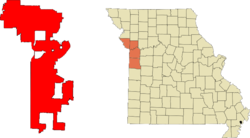
| কাউন্টি | Jackson Clay Platte Cass |
| Incorporated | March 28, 1853 |
| সরকার | |
| • Mayor | Sly James |
| আয়তন[১] | |
| • শহর | ৩১৯.০৩ বর্গমাইল (৮২৬.২৮ বর্গকিমি) |
| • স্থলভাগ | ৩১৪.৯৫ বর্গমাইল (৮১৫.৭২ বর্গকিমি) |
| • জলভাগ | ৪.০৮ বর্গমাইল (১০.৫৭ বর্গকিমি) |
| • পৌর এলাকা | ৫৮৪.৪ বর্গমাইল (১,৫১৩.৫৯ বর্গকিমি) |
| • মহানগর | ৭,৯৫২ বর্গমাইল (২০,৫৯৬ বর্গকিমি) |
| উচ্চতা | ৯১০ ফুট (২৭৭ মিটার) |
| জনসংখ্যা (2013[২]) | |
| • শহর | ৪,৬৭,০০৭ |
| • ক্রম | US: 37th |
| • জনঘনত্ব | ১,৪৭৪.২/বর্গমাইল (৫৬৯.২/বর্গকিমি) |
| • পৌর এলাকা | ১৫,১৯,৪১৭ (৩১st) |
| • মহানগর | ২০,৩৮,৭২৪ (৩০th) |
| বিশেষণ | Kansas Citian |
| সময় অঞ্চল | CST (ইউটিসি−6) |
| • গ্রীষ্মকালীন (দিসস) | CDT (ইউটিসি−5) |
| ZIP Code | 64101-64102, 64105-64106, 64108-64114, 64116-64134, 64136-64139, 64141, 64144-64158, 64161, 64163-64168, 64170-64172, 64179-64180, 64183-64185, 64187-64188, 64190-64199, 64944, 64999 |
| এলাকা কোড | 816, 975(planned) |
| FIPS code | 29-38000[৩] |
| GNIS feature ID | 0748198[৪] |
| ওয়েবসাইট | kcmo.org |
কানসাস সিটি (ইংরেজি: Kansas City) আমেরিকার মিসৌরি অঙ্গরাজ্যের বৃহত্তম শহর এবং মার্কিন যুক্তরাষ্ট্রের ৩৭তম জনবহুল শহর।
তথ্যসূত্র
- ↑ "US Gazetteer files 2010"। United States Census Bureau। সংগ্রহের তারিখ ২০১২-০৭-০৮।
|publisher=এ বহিঃসংযোগ দেয়া (সাহায্য) - ↑ "Population Estimates"। United States Census Bureau। সংগ্রহের তারিখ ২০১৩-০৫-২৯।
- ↑ "American FactFinder"। United States Census Bureau। সংগ্রহের তারিখ ২০০৮-০১-৩১।
- ↑ "US Board on Geographic Names"। United States Geological Survey। ২০০৭-১০-২৫। সংগ্রহের তারিখ ২০০৮-০১-৩১।
| এই নিবন্ধটি অসম্পূর্ণ। আপনি চাইলে এটিকে সম্প্রসারিত করে উইকিপিডিয়াকে সাহায্য করতে পারেন। |


