শারন্ত্-ম্যারিটাইম: সংশোধিত সংস্করণের মধ্যে পার্থক্য
বিষয়বস্তু বিয়োগ হয়েছে বিষয়বস্তু যোগ হয়েছে
Ashiq Shawon (আলোচনা | অবদান) নতুন নিবন্ধন |
Ashiq Shawon (আলোচনা | অবদান) অ পরিবর্ধন |
||
| ১ নং লাইন: | ১ নং লাইন: | ||
{{Infobox department |
|||
<!-- See Template:Infobox department for additional fields and descriptions --> |
|||
| name = শ্যারেন্ট-ম্যারিটাইম |
|||
| native_name = |
|||
| native_name_lang = fr<!-- ISO 639-2 code e.g. "fr" for French. If more than one, use {{lang}} instead --> |
|||
| type = [[ফ্রান্সের প্রশাসনিক বিভাগ|বিভাগ]] |
|||
| image_skyline = 920 - Hôtel Poupet Préfecture 40 rue Réaumur - La Rochelle.jpg |
|||
| image_alt = |
|||
| image_caption = শ্যারেন্ট-ম্যারিটাইম বিভাগের প্রশাসনিক ভবন |
|||
| image_flag = |
|||
| flag_alt = |
|||
| image_shield = Blason département fr Charente-Maritime.svg |
|||
| shield_alt = |
|||
| nickname = |
|||
| motto = |
|||
| image_map = Charente-Maritime-Position.svg |
|||
| map_alt = |
|||
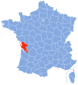
| map_caption = ফ্রান্সের মানচিত্রে শ্যারেন্ট-ম্যারিটাইম-এর অবস্থান |
|||
| pushpin_map = |
|||
| pushpin_label_position = |
|||
| pushpin_map_alt = |
|||
| pushpin_map_caption = |
|||
| latd = 45|latm = 57|lats = |latNS = N |
|||
| longd = 0|longm = 58|longs = |longEW = W |
|||
| coor_pinpoint = |
|||
| coordinates_type = region:FR_type:adm2nd |
|||
| coordinates_display = inline,title |
|||
| coordinates_footnotes = |
|||
| coordinates_region = FR |
|||
| subdivision_type = Country |
|||
| subdivision_name = France |
|||
| subdivision_type1 = [[Regions of France|Region]] |
|||
| subdivision_name1 = [[Poitou-Charentes]] |
|||
| established_title = |
|||
| established_date = |
|||
| founder = |
|||
| seat_type = [[Prefectures in France|Prefecture]] |
|||
| seat = [[La Rochelle]] |
|||
| parts_type = [[Subprefectures in France|Subprefectures]] |
|||
| parts_style = para |
|||
| p1 = [[Jonzac]]<br>[[Rochefort, Charente-Maritime|Rochefort]]<br>[[Saintes, Charente-Maritime|Saintes]]<br>[[Saint-Jean-d'Angély]] |
|||
| government_footnotes = |
|||
| leader_party = [[Union for a Popular Movement|UMP]] |
|||
| leader_title = [[President of the general council|President of the General Council]] |
|||
| leader_name = [[Dominique Bussereau]] |
|||
| unit_pref = Metric<!-- or US or UK --> |
|||
| area_magnitude = |
|||
| area_footnotes = {{ref|area|1}} |
|||
| area_total_km2 = 6864 |
|||
| area_note = |
|||
| elevation_footnotes = |
|||
| elevation_m = |
|||
| elevation_min_m = |
|||
| elevation_max_m = |
|||
| population_footnotes = |
|||
| population_total = 605410 |
|||
| population_as_of = 2007 |
|||
| population_rank = [[List of French departments by population|39th]] |
|||
| population_density_km2 = auto |
|||
| population_demonym = |
|||
| population_note = |
|||
| blank_name_sec1 = [[Departments of France|Department number]] |
|||
| blank_info_sec1 = 17 |
|||
| blank_name_sec2 = [[Arrondissements of France|Arrondissements]] |
|||
| blank_info_sec2 = [[arrondissements of the Charente-Maritime department|5]] |
|||
| blank1_name_sec2 = [[Cantons in France|Cantons]] |
|||
| blank1_info_sec2 = [[cantons of the Charente-Maritime department|51]] |
|||
| blank2_name_sec2 = [[Communes in France|Communes]] |
|||
| blank2_info_sec2 = [[communes of the Charente-Maritime department|472]] |
|||
| timezone1 = [[Central European Time|CET]] |
|||
| utc_offset1 = +1 |
|||
| timezone1_DST = [[Central European Summer Time|CEST]] |
|||
| utc_offset1_DST = +2 |
|||
| postal_code_type = |
|||
| postal_code = |
|||
| area_code_type = |
|||
| area_code = |
|||
| iso_code = |
|||
| website = |
|||
| footnotes = {{note|area|1}} French Land Register data, which exclude [[estuary|estuaries]], and lakes, ponds, and glaciers larger than 1 km<sup>2</sup> |
|||
}} |
|||
'''শ্যারেন্ট-ম্যারিটাইম''' ({{IPA-fr|ʃa.ʁɑ̃t ma.ʁi.tim}}) [[ফ্রান্স|ফ্রান্সের]] দক্ষিণ-পশ্চিম উপকূলীয় অঞ্চলের একটি প্রশাসনিক বিভাগ যার নামকরণ [[শ্যারেন্ট নদী|শ্যারেন্ট নদীর]] নামানুসারে করা হয়েছে। |
'''শ্যারেন্ট-ম্যারিটাইম''' ({{IPA-fr|ʃa.ʁɑ̃t ma.ʁi.tim}}) [[ফ্রান্স|ফ্রান্সের]] দক্ষিণ-পশ্চিম উপকূলীয় অঞ্চলের একটি প্রশাসনিক বিভাগ যার নামকরণ [[শ্যারেন্ট নদী|শ্যারেন্ট নদীর]] নামানুসারে করা হয়েছে। |
||
{{Departments of France}} |
|||
[[বিষয়শ্রেণী:১৭৯০-এ ফ্রান্সে প্রতিষ্ঠিত]] |
[[বিষয়শ্রেণী:১৭৯০-এ ফ্রান্সে প্রতিষ্ঠিত]] |
||
২১:০৭, ২৭ অক্টোবর ২০১৩ তারিখে সংশোধিত সংস্করণ
| শ্যারেন্ট-ম্যারিটাইম | |
|---|---|
| বিভাগ | |
 শ্যারেন্ট-ম্যারিটাইম বিভাগের প্রশাসনিক ভবন | |
 ফ্রান্সের মানচিত্রে শ্যারেন্ট-ম্যারিটাইম-এর অবস্থান | |
| স্থানাঙ্ক: ৪৫°৫৭′ উত্তর ০°৫৮′ পশ্চিম / ৪৫.৯৫০° উত্তর ০.৯৬৭° পশ্চিম | |
| Country | France |
| Region | Poitou-Charentes |
| Prefecture | La Rochelle |
| Subprefectures | Jonzac Rochefort Saintes Saint-Jean-d'Angély |
| সরকার | |
| • President of the General Council | Dominique Bussereau (UMP) |
| আয়তন1 | |
| • মোট | ৬,৮৬৪ বর্গকিমি (২,৬৫০ বর্গমাইল) |
| জনসংখ্যা (2007) | |
| • মোট | ৬,০৫,৪১০ |
| • ক্রম | 39th |
| • জনঘনত্ব | ৮৮/বর্গকিমি (২৩০/বর্গমাইল) |
| সময় অঞ্চল | CET (ইউটিসি+1) |
| • গ্রীষ্মকালীন (দিসস) | CEST (ইউটিসি+2) |
| Department number | 17 |
| Arrondissements | 5 |
| Cantons | 51 |
| Communes | 472 |
| ^1 French Land Register data, which exclude estuaries, and lakes, ponds, and glaciers larger than 1 km2 | |
শ্যারেন্ট-ম্যারিটাইম (ফরাসি উচ্চারণ: [ʃa.ʁɑ̃t ma.ʁi.tim]) ফ্রান্সের দক্ষিণ-পশ্চিম উপকূলীয় অঞ্চলের একটি প্রশাসনিক বিভাগ যার নামকরণ শ্যারেন্ট নদীর নামানুসারে করা হয়েছে।

