
চিত্র:World 1914 empires colonies territory.PNG

এই প্রাকদর্শনের আকার: ৮০০ × ৩৩০ পিক্সেল। অন্যান্য আকারসমূহ: ৩২০ × ১৩২ পিক্সেল | ৬৪০ × ২৬৪ পিক্সেল | ১,৫২২ × ৬২৮ পিক্সেল।
পূর্ণ রেজোলিউশন (১,৫২২ × ৬২৮ পিক্সেল, ফাইলের আকার: ৪৫ কিলোবাইট, এমআইএমই ধরন: image/png)
| এই ফাইলটি উইকিমিডিয়া কমন্স থেকে নেওয়া। সেখানের বর্ণনা পাতার বিস্তারিত নিম্নে দেখানো হলো। (সম্পাদনা)
|

|
This map image could be re-created using vector graphics as an SVG file. This has several advantages; see Commons:Media for cleanup for more information. If an SVG form of this image is available, please upload it and afterwards replace this template with
{{vector version available|new image name}}.
It is recommended to name the SVG file “World 1914 empires colonies territory.svg”—then the template Vector version available (or Vva) does not need the new image name parameter. |
সারাংশ
| বিবরণ |
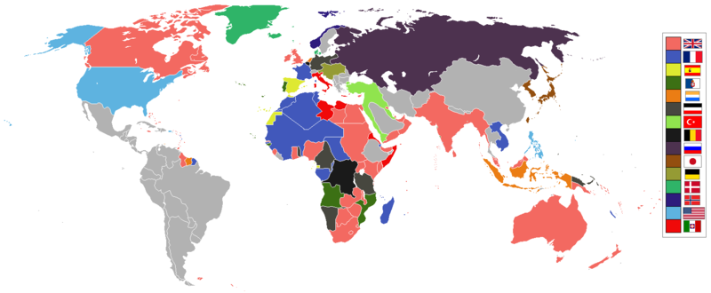
English: World empires and colonies in 1914, just before the First World War.
|
||||||||||||||||
| তারিখ | |||||||||||||||||
| উৎস | নিজের কাজ | ||||||||||||||||
| লেখক | Andrew0921 | ||||||||||||||||
.jpg)
._LOC_2001620596.jpg)
British Empire
France
Spain
Portugal
Netherlands
German Empire
Ottoman
Belgium
Russia
Japan
Denmark
Norway
United States of America
Italy
Independent/other countries
লাইসেন্স প্রদান
আমি, এই কাজের স্বত্বাধিকারী, এতদ্দ্বারা আমি এই কাজকে নিম্ন বর্ণিত লাইসেন্সের আওতায় প্রকাশ করলাম:
এই ফাইলটি ক্রিয়েটিভ কমন্স অ্যাট্রিবিউশন ৩.০ আনপোর্টেড লাইসেন্সের আওতায় লাইসেন্সকৃত।
- আপনি স্বাধীনভাবে:
- বণ্টন করতে পারেন – এ কাজটি অনুলিপি, বিতরণ এবং প্রেরণ করতে পারেন
- পুনঃমিশ্রণ করতে পারেন – কাজটি অভিযোজন করতে পারেন
- নিম্নের শর্তাবলীর ভিত্তিতে:
- স্বীকৃতিপ্রদান – আপনাকে অবশ্যই যথাযথ স্বীকৃতি প্রদান করতে হবে, লাইসেন্সের একটি লিঙ্ক সরবরাহ করতে হবে এবং কোনো পরিবর্তন হয়েছে কিনা তা নির্দেশ করতে হবে। আপনি যেকোনো যুক্তিসঙ্গত পদ্ধতিতে এটি করতে পারেন। কিন্তু এমন ভাবে নয়, যাতে প্রকাশ পায় যে লাইসেন্সধারী আপনাকে বা আপনার এই ব্যবহারের জন্য অনুমোদন দিয়েছে।
ফাইলের ইতিহাস
যেকোনো তারিখ/সময়ে ক্লিক করে দেখুন ফাইলটি তখন কী অবস্থায় ছিল।
| তারিখ/সময় | সংক্ষেপচিত্র | মাত্রা | ব্যবহারকারী | মন্তব্য | |
|---|---|---|---|---|---|
| বর্তমান | ০৯:২৮, ৮ নভেম্বর ২০২১ | | ১,৫২২ × ৬২৮ (৪৫ কিলোবাইট) | Randomastwritter | jubaland |
| ০০:০০, ১৪ এপ্রিল ২০২১ |  | ১,৫২২ × ৬২৮ (৪৫ কিলোবাইট) | Offa29 | Fixed Togoland colour | |
| ১৮:৫৭, ২৪ এপ্রিল ২০২০ |  | ১,৫২২ × ৬২৮ (৪৫ কিলোবাইট) | The- | Norwegian flag | |
| ১৭:০৮, ২৪ এপ্রিল ২০২০ |  | ১,৫২২ × ৬২৮ (৪৫ কিলোবাইট) | The- | If an old map with wrongly drawn borders is replaced with a better map wth a minor colour error, then fix that minor colour error. Don't just blithely revert to the bad old map. | |
| ২১:৫২, ১৭ মার্চ ২০২০ |  | ১,৪৭৪ × ৬২০ (৩৬ কিলোবাইট) | Makkkkus | Replaced the Swedish-Norwegian union flag with the Norwegian flag. | |
| ১৯:২৫, ১৩ মার্চ ২০২০ |  | ১,৪৭৪ × ৬২০ (২২ কিলোবাইট) | Morris-frank | The new version introduced a big regression (coloring spain in the color of italy), also it did not contribute anything useful. | |
| ২১:৪৯, ১৪ আগস্ট ২০১৯ |  | ১,৫২২ × ৬২৮ (৪৫ কিলোবাইট) | The- | More accurate map | |
| ১২:৪৭, ৫ জুলাই ২০১৬ |  | ১,৪৭৪ × ৬২০ (২২ কিলোবাইট) | Maproom | Removed borders between provinces of Australia, as requested at https://en.wikipedia.org/wiki/Wikipedia:Graphics_Lab/Map_workshop#FIFA_World_Cup_Maps_-_Colonial_Boundaries , because it had been united into a single dominion before 1914. | |
| ০০:০০, ২৬ ডিসেম্বর ২০১০ |  | ১,৪৭৪ × ৬২০ (৩৩ কিলোবাইট) | Quigley | by 1914, Qing Dynasty had collapsed and Republic of China established | |
| ১৩:৫৬, ২২ নভেম্বর ২০১০ |  | ১,৪৭৪ × ৬২০ (২০ কিলোবাইট) | AnonMoos | cropping margins, increasing PNG compression |
সংযোগসমূহ
নিচের পৃষ্ঠা(গুলো) থেকে এই ছবিতে সংযোগ আছে:
ফাইলের বৈশ্বিক ব্যবহার
নিচের অন্যান্য উইকিগুলো এই ফাইলটি ব্যবহার করে:
- af.wikipedia.org-এ ব্যবহার
- ar.wikipedia.org-এ ব্যবহার
- azb.wikipedia.org-এ ব্যবহার
- ca.wikipedia.org-এ ব্যবহার
- da.wikipedia.org-এ ব্যবহার
- en.wikipedia.org-এ ব্যবহার
- eo.wikipedia.org-এ ব্যবহার
- eo.wikiquote.org-এ ব্যবহার
- es.wikipedia.org-এ ব্যবহার
- fa.wikipedia.org-এ ব্যবহার
- fi.wikipedia.org-এ ব্যবহার
- fr.wikipedia.org-এ ব্যবহার
- fy.wikipedia.org-এ ব্যবহার
- gl.wikipedia.org-এ ব্যবহার
- hu.wikipedia.org-এ ব্যবহার
- it.wikipedia.org-এ ব্যবহার
- ja.wikipedia.org-এ ব্যবহার
- jv.wikipedia.org-এ ব্যবহার
- ka.wikipedia.org-এ ব্যবহার
- lv.wikipedia.org-এ ব্যবহার
- mk.wikipedia.org-এ ব্যবহার
- ml.wikipedia.org-এ ব্যবহার
- oc.wikipedia.org-এ ব্যবহার
- pt.wikipedia.org-এ ব্যবহার
- ta.wikipedia.org-এ ব্যবহার
- te.wikipedia.org-এ ব্যবহার
- th.wikipedia.org-এ ব্যবহার
এই ফাইলের অন্যান্য বৈশ্বিক ব্যবহার দেখুন।