
চিত্র:USA territorial growth.gif

এই প্রাকদর্শনের আকার: ৮০০ × ৪৯৮ পিক্সেল। অন্যান্য আকারসমূহ: ৩২০ × ১৯৯ পিক্সেল | ৬৪০ × ৩৯৮ পিক্সেল | ৯২১ × ৫৭৩ পিক্সেল।
পূর্ণ রেজোলিউশন (৯২১ × ৫৭৩ পিক্সেল, ফাইলের আকার: ২.০১ মেগাবাইট, এমআইএমই ধরন: image/gif, লুপকৃত, ১০ ফ্রেম, ৫০ সে)
| এই ফাইলটি উইকিমিডিয়া কমন্স থেকে নেওয়া। সেখানের বর্ণনা পাতার বিস্তারিত নিম্নে দেখানো হলো। (সম্পাদনা)
|
সারাংশ
| বিবরণ |
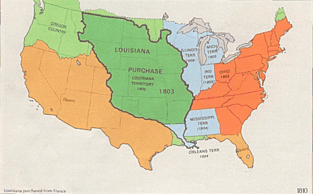
English: US territorial growth 1810–1920, based on the PD USGS maps in Category:Territorial growth maps of the United States.
See key below for explanation of colors.  |
||||||
| উৎস |
|
||||||
| লেখক |
|
||||||
| অন্যান্য সংস্করণ |
|

লাইসেন্স প্রদান
This image is in the public domain in the United States because it only contains materials that originally came from the United States Geological Survey, an agency of the United States Department of the Interior. For more information, see the official USGS copyright policy.
|
ফাইলের ইতিহাস
যেকোনো তারিখ/সময়ে ক্লিক করে দেখুন ফাইলটি তখন কী অবস্থায় ছিল।
| তারিখ/সময় | সংক্ষেপচিত্র | মাত্রা | ব্যবহারকারী | মন্তব্য | |
|---|---|---|---|---|---|
| বর্তমান | ০১:৩৯, ৩১ মে ২০০৬ | | ৯২১ × ৫৭৩ (২.০১ মেগাবাইট) | Roke~commonswiki | longer interval, 3 seconds --> 5 seconds |
| ১২:২১, ৩০ মে ২০০৬ |  | ৯২১ × ৫৭৩ (২.৬৭ মেগাবাইট) | Roke~commonswiki | US territorial growth 1810-1920, based on the USGS maps in commons:Category:USA Territorial Growth Maps, put together in Corel Painter IX. The individual maps have this licence: {{PD-USGov-USGS}} If it is necessary for me to licence my contributio |
সংযোগসমূহ
নিচের পৃষ্ঠা(গুলো) থেকে এই ছবিতে সংযোগ আছে:
ফাইলের বৈশ্বিক ব্যবহার
নিচের অন্যান্য উইকিগুলো এই ফাইলটি ব্যবহার করে:
- en.wikipedia.org-এ ব্যবহার
- es.wikipedia.org-এ ব্যবহার
- fa.wikipedia.org-এ ব্যবহার
- fy.wikipedia.org-এ ব্যবহার
- ha.wikipedia.org-এ ব্যবহার
- he.wikipedia.org-এ ব্যবহার
- nl.wikipedia.org-এ ব্যবহার
- pnb.wikipedia.org-এ ব্যবহার
- ru.wikipedia.org-এ ব্যবহার
- ru.wikinews.org-এ ব্যবহার
- sr.wikipedia.org-এ ব্যবহার
- tr.wikipedia.org-এ ব্যবহার
- ur.wikipedia.org-এ ব্যবহার
- uz.wikipedia.org-এ ব্যবহার
- www.wikidata.org-এ ব্যবহার