
চিত্র:Tambora EFS highres STS049 STS049-97-54.jpg
এই প্রাকদর্শনের আকার: ৫৯৬ × ৫৯৯ পিক্সেল। অন্যান্য আকারসমূহ: ২৩৯ × ২৪০ পিক্সেল | ৪৭৭ × ৪৮০ পিক্সেল | ৭৬৪ × ৭৬৮ পিক্সেল | ১,০১৮ × ১,০২৪ পিক্সেল | ২,০৩৭ × ২,০৪৮ পিক্সেল | ৩,৯৪০ × ৩,৯৬২ পিক্সেল।
পূর্ণ রেজোলিউশন (৩,৯৪০ × ৩,৯৬২ পিক্সেল, ফাইলের আকার: ২.৬১ মেগাবাইট, এমআইএমই ধরন: image/jpeg)
| এই ফাইলটি উইকিমিডিয়া কমন্স থেকে নেওয়া। সেখানের বর্ণনা পাতার বিস্তারিত নিম্নে দেখানো হলো। (সম্পাদনা)
|
সারাংশ
| বিবরণ |
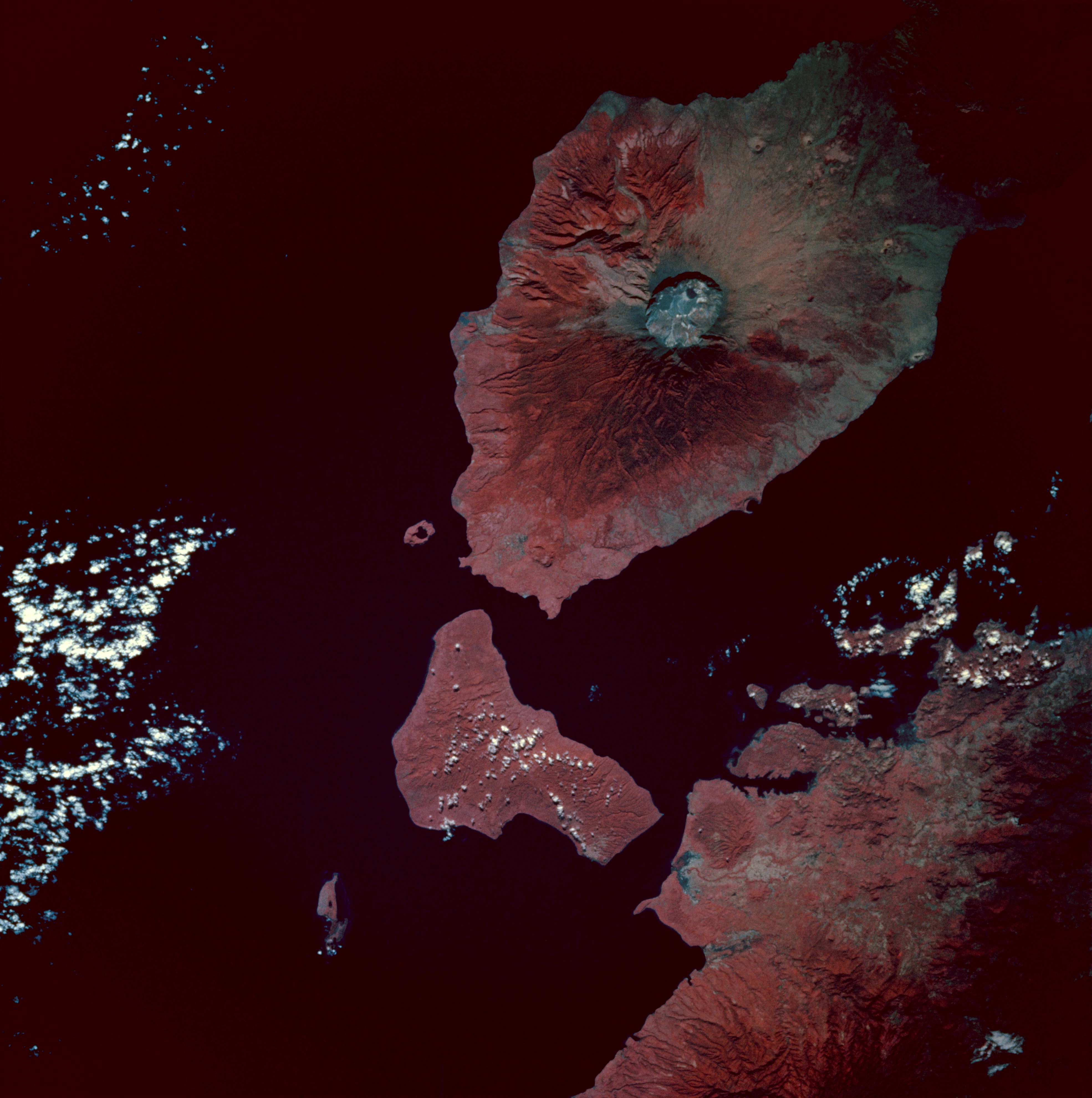
Infrared image of Mount Tambora, Sumbawa Island, Indonesia. Taken from the space shuttle Endeavour at 0:54 GMT on 13 May 1992.
|
| তারিখ | |
| উৎস | [2] |
| লেখক | Image Science and Analysis Laboratory, NASA-Johnson Space Center. "The Gateway to Astronaut Photography of Earth". |
লাইসেন্স প্রদান
| এই ফাইলটি পাবলিক ডোমেইনে আছে কারণ এটি শুধুমাত্র নাসা কর্তৃক নির্মিত হয়েছিল। নাসার কপিরাইট নীতি হচ্ছে যে "নাসা কর্তৃক উল্লেখ না থাকলে নাসার উপাদান কপিরাইট দ্বারা সুরক্ষিত নয়"। (Template:PD-USGov, নাসার কপিরাইট নীতির পাতা অথবা জেপিএল চিত্র ব্যবহারের নীতি দেখুন।) | ||
 |
সতর্কবার্তা:
|
ফাইলের ইতিহাস
যেকোনো তারিখ/সময়ে ক্লিক করে দেখুন ফাইলটি তখন কী অবস্থায় ছিল।
| তারিখ/সময় | সংক্ষেপচিত্র | মাত্রা | ব্যবহারকারী | মন্তব্য | |
|---|---|---|---|---|---|
| বর্তমান | ০৮:৪৯, ৮ ফেব্রুয়ারি ২০১০ | | ৩,৯৪০ × ৩,৯৬২ (২.৬১ মেগাবাইট) | Avenue | {{Information |Description=Infrared image of Mount Tambora, Sumbawa Island, Indonesia. Taken from the space shuttle Endeavour at 0:54 GMT on 13 May 1992. <br/>Description from [http://city.jsc.nasa.gov/sseop/EFS/photoinfo.pl?PHOTO=STS049-97-54]:<br/> The |
সংযোগসমূহ
নিচের পৃষ্ঠা(গুলো) থেকে এই ছবিতে সংযোগ আছে:
ফাইলের বৈশ্বিক ব্যবহার
নিচের অন্যান্য উইকিগুলো এই ফাইলটি ব্যবহার করে:
- ar.wikipedia.org-এ ব্যবহার
- ast.wikipedia.org-এ ব্যবহার
- br.wikipedia.org-এ ব্যবহার
- el.wikipedia.org-এ ব্যবহার
- en.wikipedia.org-এ ব্যবহার
- es.wikipedia.org-এ ব্যবহার
- id.wikipedia.org-এ ব্যবহার
- mk.wikipedia.org-এ ব্যবহার
- ms.wikipedia.org-এ ব্যবহার
- pt.wikipedia.org-এ ব্যবহার
- ro.wikipedia.org-এ ব্যবহার
- tr.wikipedia.org-এ ব্যবহার
- Tambora Dağı
- 1815 Tambora Dağı patlaması
- Kullanıcı:Anerka/Takip/Biliyor muydunuz?
- Kullanıcı:LostMyMind/BM logları
- Vikipedi:Biliyor muydunuz?/Arşiv/2022+
- Vikipedi:Biliyor muydunuz?/2023-03-05
- Vikipedi:Biliyor muydunuz/Mart 2023
- Vikipedi:Biliyor muydunuz/Şubat 2024
- Vikipedi:Biliyor muydunuz?/2024-02-13
- zh.wikipedia.org-এ ব্যবহার