
চিত্র:South Pacific Mandate map in 1930s.PNG

এই প্রাকদর্শনের আকার: ৮০০ × ৪৮৯ পিক্সেল। অন্যান্য আকারসমূহ: ৩২০ × ১৯৬ পিক্সেল | ৬৪০ × ৩৯১ পিক্সেল | ১,০২৪ × ৬২৬ পিক্সেল | ১,২৮০ × ৭৮৩ পিক্সেল | ১,৭৫১ × ১,০৭১ পিক্সেল।
পূর্ণ রেজোলিউশন (১,৭৫১ × ১,০৭১ পিক্সেল, ফাইলের আকার: ৮৯৫ কিলোবাইট, এমআইএমই ধরন: image/png)
| এই ফাইলটি উইকিমিডিয়া কমন্স থেকে নেওয়া। সেখানের বর্ণনা পাতার বিস্তারিত নিম্নে দেখানো হলো। (সম্পাদনা)
|
সারাংশ
| বিবরণ |
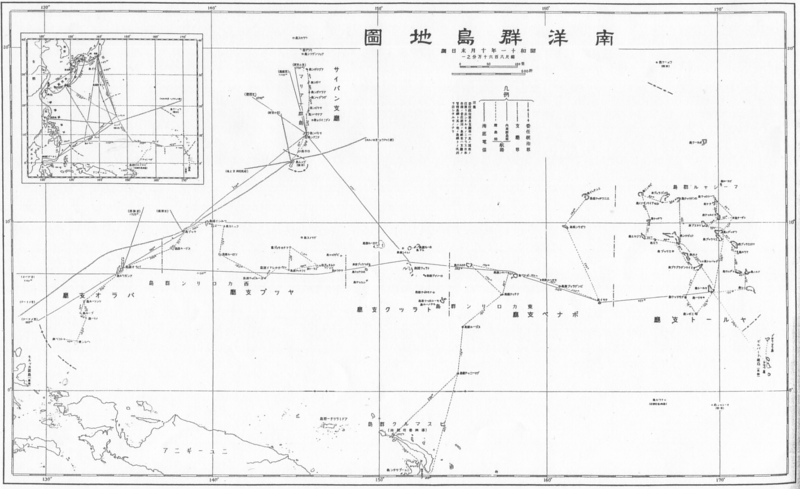
English: South Pacific Mandate map in 1930s 日本語: 1930年代の南洋群島地図 |
| তারিখ | 1930-এর দশক |
| উৎস |
English: Japanese book "Photograph collection of exterior territories of Japan" published by Tokai-Tsushinsha. 日本語: 東海通信社「大日本外地写真帖」より。 |
| লেখক | অজানা |
লাইসেন্স প্রদান
This photograph is in the public domain in Japan because its copyright has expired according to Article 23 of the 1899 Copyright Act of Japan (English translation) and Article 2 of Supplemental Provisions of Copyright Act of 1970. This is when the photograph meets one of the following conditions:
|
 | |
 |
To uploader: Please provide the source and publication date.
|
ফাইলের ইতিহাস
যেকোনো তারিখ/সময়ে ক্লিক করে দেখুন ফাইলটি তখন কী অবস্থায় ছিল।
| তারিখ/সময় | সংক্ষেপচিত্র | মাত্রা | ব্যবহারকারী | মন্তব্য | |
|---|---|---|---|---|---|
| বর্তমান | ০০:২৮, ২৩ ডিসেম্বর ২০১০ | | ১,৭৫১ × ১,০৭১ (৮৯৫ কিলোবাইট) | あばさー | {{Information |Description={{en|South Pacific Mandate map in 1930s}}{{ja|1930年代の南洋群島地図}} |Source={{en|Japanese book "Photograph collection of exterior territories of Japan" published by Tokai-Tsushinsha.}}{{ja|東海通信社「大日本 |
সংযোগসমূহ
নিচের পৃষ্ঠা(গুলো) থেকে এই ছবিতে সংযোগ আছে:
ফাইলের বৈশ্বিক ব্যবহার
নিচের অন্যান্য উইকিগুলো এই ফাইলটি ব্যবহার করে:
- azb.wikipedia.org-এ ব্যবহার
- de.wikipedia.org-এ ব্যবহার
- en.wikipedia.org-এ ব্যবহার
- fa.wikipedia.org-এ ব্যবহার
- id.wikipedia.org-এ ব্যবহার
- ko.wikipedia.org-এ ব্যবহার
- vi.wikipedia.org-এ ব্যবহার
- zh.wikipedia.org-এ ব্যবহার