
চিত্র:South America southern tip pol.png

এই প্রাকদর্শনের আকার: ৮০০ × ৪৯৪ পিক্সেল। অন্যান্য আকারসমূহ: ৩২০ × ১৯৮ পিক্সেল | ৬৪০ × ৩৯৫ পিক্সেল | ১,০২৪ × ৬৩২ পিক্সেল | ১,২৮০ × ৭৯০ পিক্সেল | ২,৫৬০ × ১,৫৮১ পিক্সেল | ৩,৮৫৯ × ২,৩৮৩ পিক্সেল।
পূর্ণ রেজোলিউশন (৩,৮৫৯ × ২,৩৮৩ পিক্সেল, ফাইলের আকার: ৫৯৬ কিলোবাইট, এমআইএমই ধরন: image/png)
| এই ফাইলটি উইকিমিডিয়া কমন্স থেকে নেওয়া। সেখানের বর্ণনা পাতার বিস্তারিত নিম্নে দেখানো হলো। (সম্পাদনা)
|
সারাংশ
| বিবরণ |
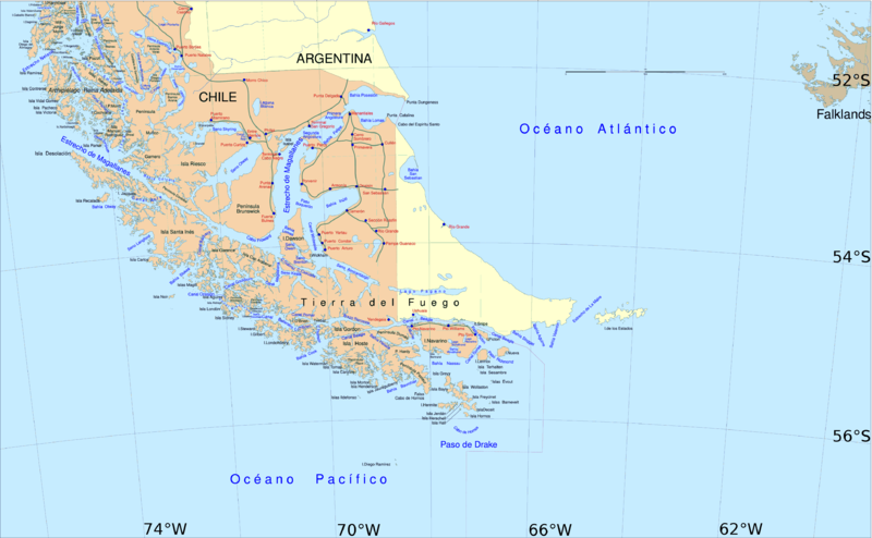
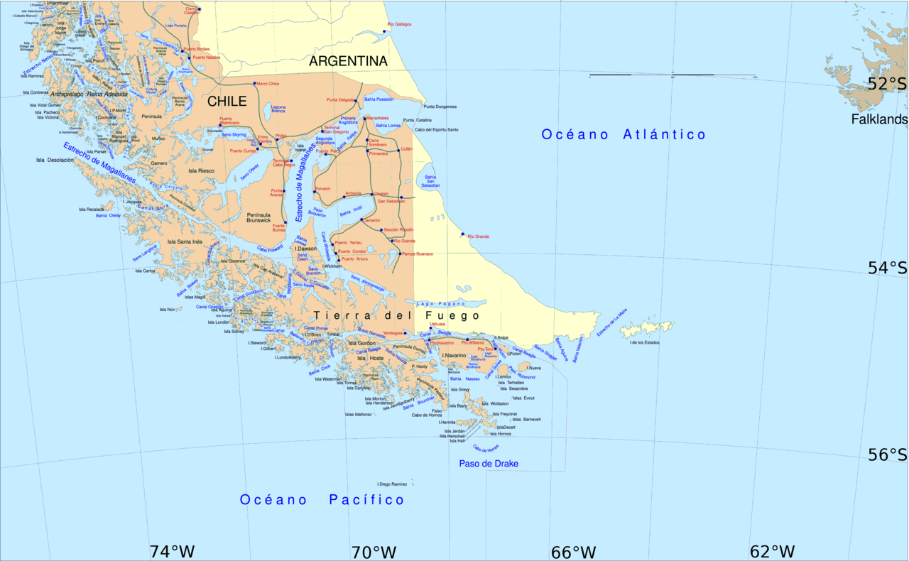
English: Political map of southern Chile and Argentina, from Straits of Magellan to Cape Horn.
Español: Mapa político del sur de Chile y la Argentina, entre el estrecho de Magallanes y el cabo de Hornos. |
||||
| তারিখ | |||||
| উৎস | File:Sur2.gif | ||||
| লেখক | User:Createaccount | ||||
| অনুমতি (এ ফাইলের পুনঃব্যবহার) |
|
||||
| অন্যান্য সংস্করণ | এই ফাইলের উপজাত কর্মসমূহ: Metula.svg |
লাইসেন্স প্রদান

|
এই নথি অনুলিপি, বিতরণ এবং/বা পরিবর্তন করার অনুমতি ফ্রি সফটওয়্যার ফাউন্ডেশন কর্তৃক প্রকাশিত গনু ফ্রি ডকুমেন্টেশন লাইসেন্স, সংস্করণ ১.২ বা তার পরবর্তী সংস্করণের আওতায় অনুমতিপ্রাপ্ত; যে কোনো রকম অনুচ্ছেদ পরিবর্তন, সম্মুখ-প্রচ্ছদের লেখা, পিছন-প্রচ্ছদের লেখা পরিবর্তন করা ছাড়াই। এই লাইসেন্সের একটি অনুলিপি গনু ফ্রি ডকুমেন্টেশন লাইসেন্স শিরোনামের অনুচ্ছেদে অন্তর্ভুক্ত করা আছে। |
| এই ফাইলটি ক্রিয়েটিভ কমন্স অ্যাট্রিবিউশন-শেয়ার অ্যালাইক ৩.০ আনপোর্টেড লাইসেন্সের আওতায় লাইসেন্সকৃত। | ||
| ||
| এই লাইসেন্স ট্যাগটি জিএফডিএল লাইসেন্স হালনাগাদের অংশ হিসেবে এই ফাইলে সংযুক্ত হয়েছে। |
ফাইলের ইতিহাস
যেকোনো তারিখ/সময়ে ক্লিক করে দেখুন ফাইলটি তখন কী অবস্থায় ছিল।
| তারিখ/সময় | সংক্ষেপচিত্র | মাত্রা | ব্যবহারকারী | মন্তব্য | |
|---|---|---|---|---|---|
| বর্তমান | ১৪:০৬, ৩০ এপ্রিল ২০১৬ | | ৩,৮৫৯ × ২,৩৮৩ (৫৯৬ কিলোবাইট) | Hohum | Cartographic colours |
| ১১:০৯, ৩ এপ্রিল ২০১৩ |  | ৩,৮৫৯ × ২,৩৮৩ (৫৯৭ কিলোবাইট) | Keysanger | Margin right and top cropped | |
| ১০:৪৭, ৩ এপ্রিল ২০১৩ |  | ৩,৮৫৯ × ২,৩৮৩ (৫৯৭ কিলোবাইট) | Keysanger | "Estrecho Nelson" added Bigger Latitude and Longitude within the image empty margin cropped | |
| ১৯:৩০, ৩ মে ২০০৯ |  | ৩,৮৯৪ × ২,৪৪১ (৬৩৯ কিলোবাইট) | Pitichinaccio | different colour | |
| ১৯:২৯, ৩ মে ২০০৯ |  | ৩,৮৯৪ × ২,৪৪১ (৬৩৯ কিলোবাইট) | Pitichinaccio | {{Information |Description={{en|1=political map of southern Chile/Argentina: From Straits of Magellan to Cape Horn}} |Source=File:Sur2.gif |Author=User:Createaccount |Date=2008 |Permission={{GFDL-GMT}}} |other_versions=File:Sur2.gif }} <!-- |
সংযোগসমূহ
এই ফাইল ব্যবহার করে এমন কোনো পাতা নেই।
ফাইলের বৈশ্বিক ব্যবহার
নিচের অন্যান্য উইকিগুলো এই ফাইলটি ব্যবহার করে:
- af.wikipedia.org-এ ব্যবহার
- als.wikipedia.org-এ ব্যবহার
- ar.wikipedia.org-এ ব্যবহার
- ast.wikipedia.org-এ ব্যবহার
- br.wikipedia.org-এ ব্যবহার
- ca.wikipedia.org-এ ব্যবহার
- de.wikipedia.org-এ ব্যবহার
- de.wiktionary.org-এ ব্যবহার
- el.wikipedia.org-এ ব্যবহার
- en.wikipedia.org-এ ব্যবহার
- Cape Froward
- Porvenir, Chile
- Santa Inés Island
- Puerto Toro
- False Cape Horn
- Puerto del Hambre
- Maritime history of California
- Brunswick Peninsula
- Almirantazgo Fjord
- Fjord of the Mountains
- Primera Angostura
- Aracena Island
- Punta Dúngeness
- Muñoz Gamero Peninsula
- Seno Otway
- Mitre Peninsula
- Marlborough (1876 ship)
এই ফাইলের অন্যান্য বৈশ্বিক ব্যবহার দেখুন।