
চিত্র:Plan de Paris en 1657.JPG

এই প্রাকদর্শনের আকার: ৭১৬ × ৫৯৯ পিক্সেল। অন্যান্য আকারসমূহ: ২৮৭ × ২৪০ পিক্সেল | ৫৭৩ × ৪৮০ পিক্সেল | ৯১৭ × ৭৬৮ পিক্সেল | ১,২২৩ × ১,০২৪ পিক্সেল | ২,৪৪৬ × ২,০৪৮ পিক্সেল | ৫,৫০০ × ৪,৬০৫ পিক্সেল।
পূর্ণ রেজোলিউশন (৫,৫০০ × ৪,৬০৫ পিক্সেল, ফাইলের আকার: ১৭.৬২ মেগাবাইট, এমআইএমই ধরন: image/jpeg)
| এই ফাইলটি উইকিমিডিয়া কমন্স থেকে নেওয়া। সেখানের বর্ণনা পাতার বিস্তারিত নিম্নে দেখানো হলো। (সম্পাদনা)
|
সারাংশ
| শিরোনাম |
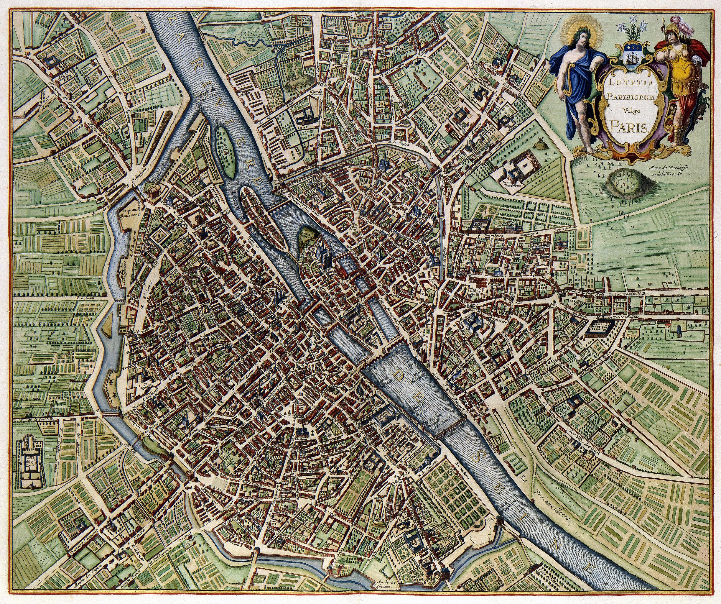
Lutetia Parisiorum vulgo Paris |
|||||||||||||||||||||||||
| বর্ণনা | ||||||||||||||||||||||||||
| তারিখ | published in 1657, the map depicts Paris as it appeared sometime after 1638 but before 1652 (see Talk page) | |||||||||||||||||||||||||
| উৎস | Geheugen van Nederland | |||||||||||||||||||||||||
| স্রষ্টা |
|
|||||||||||||||||||||||||
| Geotemporal data | ||||||||||||||||||||||||||
| ভৌগলিক সীমা |
|
|||||||||||||||||||||||||
| Warper-এ মানচিত্রের আস্তরণ | ||||||||||||||||||||||||||
| বস্তুর অবস্থান | | এটি এবং অন্যান্য ছবি তাদের অবস্থানের উপর: ওপেনস্ট্রিটম্যাপ |
|---|
মূল্যায়ন
|
এই ছবিটি উইকিমিডিয়া কমন্সে ২১ মে ২০১১-এর আজকের নির্বাচিত ছবি হিসেবে নির্বাচিত হয়েছে। নিম্নে এর ক্যাপশন রয়েছে:
|
This digital media file - and/or the physical objects depicted on it - originates from the digital and/or physical collections of the Koninklijke Bibliotheek, national library of the Netherlands.
|
লাইসেন্স প্রদান
|
This is a faithful photographic reproduction of a two-dimensional, public domain work of art. The work of art itself is in the public domain for the following reason:
The official position taken by the Wikimedia Foundation is that "faithful reproductions of two-dimensional public domain works of art are public domain".
This photographic reproduction is therefore also considered to be in the public domain in the United States. In other jurisdictions, re-use of this content may be restricted; see Reuse of PD-Art photographs for details. | ||||
ফাইলের ইতিহাস
যেকোনো তারিখ/সময়ে ক্লিক করে দেখুন ফাইলটি তখন কী অবস্থায় ছিল।
| তারিখ/সময় | সংক্ষেপচিত্র | মাত্রা | ব্যবহারকারী | মন্তব্য | |
|---|---|---|---|---|---|
| বর্তমান | ০৮:১২, ১৮ ফেব্রুয়ারি ২০১০ | | ৫,৫০০ × ৪,৬০৫ (১৭.৬২ মেগাবাইট) | Thesupermat | {{Information |Description={{fr|1=Plan de Paris par Johannes Janssonius }} |Source=http://www.geheugenvannederland.nl/?/nl/items/KONB01:259/&st=Parijs&sc=(Parijs)+AND+(isPartOf+any+%22KONB01%22+) |Author=Johannes Janssonius |Date=1657 |Permission= |othe |
সংযোগসমূহ
নিচের পৃষ্ঠা(গুলো) থেকে এই ছবিতে সংযোগ আছে:
ফাইলের বৈশ্বিক ব্যবহার
নিচের অন্যান্য উইকিগুলো এই ফাইলটি ব্যবহার করে:
- ba.wikipedia.org-এ ব্যবহার
- be-tarask.wikipedia.org-এ ব্যবহার
- ca.wikipedia.org-এ ব্যবহার
- crh.wikipedia.org-এ ব্যবহার
- cv.wikipedia.org-এ ব্যবহার
- da.wikipedia.org-এ ব্যবহার
- el.wikipedia.org-এ ব্যবহার
- en.wikipedia.org-এ ব্যবহার
- fr.wikipedia.org-এ ব্যবহার
- fy.wikipedia.org-এ ব্যবহার
- hr.wikipedia.org-এ ব্যবহার
- hu.wikipedia.org-এ ব্যবহার
- ko.wikipedia.org-এ ব্যবহার
- lbe.wikipedia.org-এ ব্যবহার
- lb.wikipedia.org-এ ব্যবহার
- mg.wikipedia.org-এ ব্যবহার
- nl.wikipedia.org-এ ব্যবহার
- os.wikipedia.org-এ ব্যবহার
- pl.wikipedia.org-এ ব্যবহার
- pt.wikipedia.org-এ ব্যবহার
- ru.wikipedia.org-এ ব্যবহার
- ru.wikinews.org-এ ব্যবহার
- sah.wikipedia.org-এ ব্যবহার
- su.wikipedia.org-এ ব্যবহার
- sv.wikipedia.org-এ ব্যবহার
- uk.wikipedia.org-এ ব্যবহার
- ur.wikipedia.org-এ ব্যবহার
- vi.wikipedia.org-এ ব্যবহার
- xal.wikipedia.org-এ ব্যবহার
- zh.wikipedia.org-এ ব্যবহার
এই ফাইলের অন্যান্য বৈশ্বিক ব্যবহার দেখুন।